Related Research Articles
ARA Isla de los Estados was an Argentine Navy supply ship sunk during the Falklands War.
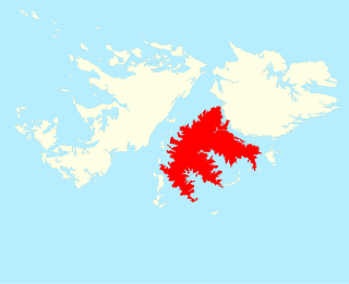
Lafonia is a peninsula forming the southern part of East Falkland, the largest of the Falkland Islands.

The Falkland Sound is a sea strait in the Falkland Islands. Running southwest-northeast, it separates West and East Falkland.

San Carlos is a settlement in northwestern East Falkland, lying south of Port San Carlos on San Carlos Water. It is sometimes nicknamed "JB" after a former owner, Jack Bonner. The settlement consists of a number of properties including a dwelling with a small cafe which also provides craft facilities. As noted in the history section, there is a small museum that pays homage to the Falklands Conflict as well as local nature and culture.

The Camp is the term used in the Falkland Islands to refer to any part of the islands outside the islands' only significant town, Stanley, and often the large RAF base at Mount Pleasant. It is derived from the Spanish word campo, for "countryside".
The Hornby Mountains are a mountain range on West Falkland in the Falkland Islands. Mount Maria is a mountain in this range. The range runs in a group of ridges parallel to Falkland Sound.

Brenton Loch is an inlet-cum-small fjord in the Falkland Islands. It is one of a handful of sea lochs outside Scotland. It is sometimes known as "Brenton Sound". "Loch" is normally pronounced as "lock" in the English rather than Scottish manner, i.e. without a fricative "ch". The far south of the loch is known as "La Boca" or "The Boca".

Hope Place was a small settlement in Lafonia in East Falkland. It was set up in 1846, by Samuel Lafone, a British-born Montevideo merchant, on the south shores of Brenton Loch. It was mainly populated by Uruguayan gauchos brought in from continental South America. The area is now abandoned.

San Carlos Water is a bay/fjord on the west coast of East Falkland, facing onto the Falkland Sound.
Volunteer Point is a headland on the east coast of East Falkland, in the Falkland Islands, north-northeast of Stanley, and east of Johnson's Harbour and Berkeley Sound. It lies at the end of a narrow peninsula, which protects Volunteer Lagoon. It received its name in 1815, when the sealing ship Volunteer left a boat's crew there to collect seal skins while it went in search of opportunities elsewhere. Four years later, on 13 February 1820, the French research vessel L'Uranie struck a submerged rock just off the point but stayed afloat long enough to be beached in Berkeley Sound. All on board survived, including the Captain's wife, Rose de Freycinet, who recorded the incident in her diary.

Keppel Sound is a bay to the north of West Falkland in the Falkland Islands. Islands in/bordering the sound include Golding Island and Keppel Island.
Cape Pembroke is the easternmost point of the Falkland Islands, and is on East Falkland. There is an automated lighthouse here.
Eagle Passage is a strait in the Falkland Islands, between Lafonia in the southwest of East Falkland, and the smaller islands of Speedwell, Barren and George Island. George Island and Speedwell Island form the stretch of land to the south of the passage while East Falkland forms the northern stretch. The passage is difficult to navigate as ships may founder on the reefs and kelp lying off the surrounding islands.
Bold Cove is a small inlet on West Falkland near Port Howard on Falkland Sound, notable for its history. It runs parallel to the northern end of Port Howard, and Peake Ridge forms the west coast. It is approximately two miles long.

The James Ross Island group is a group of islands located close to the northeastern tip of the Antarctic Peninsula. The largest islands in the group are James Ross Island, Snow Hill Island, Vega Island, and Seymour Island. The islands lie to the south of the Joinville Island group. The groups contains several scientific bases, notably Marambio Base, and numerous important palaeontological sites.

Swan Point is the point on the southwest side of the entrance to Queen Charlotte Bay, forming the northeast extremity of Weddell Island in the Falkland Islands.
Chatham Harbour is the large bay indenting the central part of Weddell Island in the Falkland Islands. It is entered east of Beacon Point and west of Loop Head. The 3 km wide bay extends 5 km in southeast direction, this part of the feature forming an anchorage named Bald Road, and north of Clay Point turning for 10 km in southwest direction. Chatham Harbour is centred at 51°50′16″S60°57′32″W.
Gull Harbour is the 1.3 km wide bay indenting for 2.8 km the east coast of Weddell Island in the Falkland Islands. It is entered north of Gull Point and south of Mark Point, and is centred at 51°53′56″S60°53′20″W. The principal settlement of the island, Weddell Settlement, is situated at the head of the bay. Until the mid-nineteenth century Gull Harbour was known as Great Harbour.
Loop Head is the point on the east side of the entrance to Chatham Harbour in Weddell Island, Falkland Islands. It is located at 51°45′48″S60°53′49″W, which is 2.4 kilometres (1.5 mi) west of Swan Point and 5.5 kilometres (3.4 mi) east-northeast of Beacon Point.
References
- ↑ "Lord West recalls sinking of HMS Ardent 40 years after the Falklands War". au.news.yahoo.com. Retrieved 17 June 2022.
- ↑ Office, Great Britain Colonial (1843). Falkland Islands: Return to an Address of the Honourable the House of Commons, Dated 31 March 1843, for Copies Or Extracts of Any Correspondence Relative to the Falkland Islands, Since the Last Papers Laid Before the House Upon the 27th Day of August 1841. House of Commons. p. 19.
51°39′40″S59°07′05″W / 51.661°S 59.118°W
| | This Falkland Islands location article is a stub. You can help Wikipedia by expanding it. |