This article needs additional citations for verification .(January 2007) |

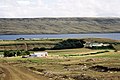
San Carlos Water is a bay/fjord on the west coast of East Falkland, facing onto the Falkland Sound.
This article needs additional citations for verification .(January 2007) |
San Carlos Water is a bay/fjord on the west coast of East Falkland, facing onto the Falkland Sound.
Despite its Spanish-sounding name, there is a wide discrepancy with the Spanish usage, for in Spanish "Estrecho de San Carlos" refers to all of the much larger Falkland Sound, which runs between the two main islands of West Falkland and East Falkland.
The settlements of San Carlos and Port San Carlos on the Water, as well as San Carlos River, all take their names from the ship San Carlos, which visited in 1768.
San Carlos Water is a fjord-like inlet at an angle of 45° to the Falkland Sound coastline, thereby offering shelter from the weather in the Sound (which is itself sheltered from the South Atlantic by bluffs in the north and an archipelago in the south). The inlet is 9.3 miles (15 km) in length and for about half of its length, is about 1.2 miles (2 km) wide. It is flat-bottomed with a depth of between 20 and 30 metres (66 and 98 ft); the 20 m isobath lying about 660 feet (200 m) offshore. [1] The tidal range at Port San Carlos varies between 0.9 and 1.6 metres (2 ft 11 in and 5 ft 3 in) (for neap and spring tides respectively) with low water being between 0.3 and 0.7 metres (1 ft 0 in and 2 ft 4 in) above the chart datum. [2] The San Carlos settlement lies close to the head of the inlet.
The inlet has eight official anchorage points. [1]
The smaller and shallower Port San Carlos is an inlet to the north of San Carlos Water. [2]
San Carlos Water became notorious during the Falklands War as "Bomb Alley" during the Battle of San Carlos. British troops routed the Argentine land forces, but British ships were pounded by Argentine air raids. It was of crucial strategic value in the amphibious assault, and British invasion of Argentine-occupied East Falkland.
Along with Grantham Sound, it is one of the proposed East Falkland terminals for the anticipated ferry to West Falkland.


The Falkland Islands are located in the South Atlantic Ocean between 51°S and 53°S on a projection of the Patagonian Shelf, part of the South American continental shelf. In ancient geological time this shelf was part of Gondwana, and around 400 million years ago split from what is now Africa and drifted westwards from it. Today the islands are subjected to the Roaring Forties, winds that shape both their geography and climate.
Operation Sutton was the code name for the British landings on the shores of San Carlos Water, at Ajax Bay and Port San Carlos, near San Carlos on East Falkland.

West Falkland is the second largest of the Falkland Islands in the South Atlantic. It is a hilly island, separated from East Falkland by the Falkland Sound. Its area is 4,532 square kilometres, 37% of the total area of the islands. Its coastline is 1,258.7 kilometres long.

East Falkland is the largest island of the Falklands in the South Atlantic, having an area of 6,605 km2 or 54% of the total area of the Falklands. The island consists of two main land masses, of which the more southerly is known as Lafonia; it is joined by a narrow isthmus where the settlement of Goose Green is located, and it was the scene of the Battle of Goose Green during the Falklands War.

Weddell Island is one of the Falkland Islands in the South Atlantic, lying off the southwest extremity of West Falkland. It is situated 1,545 km (960 mi) west-northwest of South Georgia Island, 1,165 km (724 mi) north of Livingston Island, 606 km (377 mi) northeast of Cape Horn, 358 km (222 mi) northeast of Isla de los Estados, and 510 km (320 mi) east of the Atlantic entrance to Magellan Strait.

The Falkland Sound is a sea strait in the Falkland Islands. Running southwest-northeast, it separates West and East Falkland.

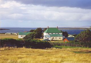
San Carlos is a settlement in northwestern East Falkland, lying south of Port San Carlos on San Carlos Water. It is sometimes nicknamed "JB" after a former owner, Jack Bonner. The settlement consists of a number of properties including a dwelling with a small cafe which also provides craft facilities. As noted in the history section, there is a small museum that pays homage to the Falklands Conflict as well as local nature and culture.

Burrard Inlet is a relatively shallow-sided fjord in northwestern Lower Mainland, British Columbia, Canada. Formed during the last Ice Age, it separates the City of Vancouver and the rest of the lowland Burrard Peninsula to the south from the coastal slopes of the North Shore Mountains, which span West Vancouver and the City and District of North Vancouver to the north.

Port San Carlos is located on the northern bank of the inlet known as Port San Carlos, off San Carlos Water on the Western coast of East Falkland, in the Falkland Islands. It is sometimes nicknamed "KC" after former owner Keith Cameron.

Port Egmont was the first British settlement in the Falkland Islands, on Saunders Island off West Falkland, and is named after John Perceval, 2nd Earl of Egmont, who was First Lord of the Admiralty at the time of its founding.
The Skirmish at Top Malo House took place on 31 May 1982 during the Falklands War between Argentine special forces from 602 Commando Company and the British Royal Marines of the Mountain and Arctic Warfare Cadre (M&AWC). Top Malo House was the only planned daylight action of the war, although it was intended to take place in darkness. The Argentine commandos were part of an attempt to establish a screen of observation posts. A section that occupied Top Malo House was sighted by a British observation post of the Mountain and Arctic Warfare Cadre that was screening the British breakout from the lodgement around San Carlos. The action at Top Malo House was one of a series of mishaps and misfortunes that afflicted the Argentine effort.

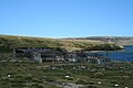
Ajax Bay is a settlement on East Falkland, in the Falkland Islands. It is on the north west coast, on the shore of San Carlos Water, a few miles from Port San Carlos. It was mainly a refrigeration plant, and was developed by the Colonial Development Corporation in the 1950s, which was also responsible for developing Port Albemarle. It was supposed to freeze Falkland mutton, but this was found to be economically unviable. Many of the pre-fabricated houses were moved to Stanley.
Teal Inlet, once named Evelyn Station, is a settlement on East Falkland, in the Falkland Islands, on the south shore of Salvador Water. It is overshadowed by Jack's Mountain.

Salvador Water or Port Salvador is a bay/inlet on the northeast coast of East Falkland, the largest of the Falkland Islands. It has an intricate shoreline, but could be described as being shaped like an "M".

The 1982 British military campaign to recapture the Falkland Islands depended on complex logistical arrangements. The logistical difficulties of operating 7,000 nautical miles from home were formidable. The Argentine invasion of the Falkland Islands came at a time when the Royal Navy was experiencing a reduction in its amphibious capability, but it still possessed the aircraft carriers HMS Hermes and Invincible, the landing platform dock (LPD) ships HMS Fearless and Intrepid, and six landing ship logistics (LSL) ships. To provide the necessary logistic support, the Royal Navy's ships were augmented by ships taken up from trade (STUFT).

Duplicate: List of Falkland Islands–related topics

The Battle of San Carlos was a battle between aircraft and ships that lasted from 21 to 25 May 1982 during the British landings on the shores of San Carlos Water in the 1982 Falklands War. Low-flying land-based Argentine jet aircraft made repeated attacks on ships of the British Task Force.

Weddell Settlement is the only settlement on Weddell Island in the Falkland Islands, situated on the east coast of the island at the head of the sheltered Gull Harbour, part of Queen Charlotte Bay. It is located at 51°53′46″S60°54′27″W, which is 12.15 kilometres (7.55 mi) northeast of Race Point, 15 kilometres (9.3 mi) south by west of Swan Point, 212 kilometres (132 mi) west-southwest of Stanley and 56.6 kilometres (35.2 mi) west of Fox Bay on West Falkland.