Falkland Sound

Last updated

The Falkland Sound, here in November 1999, is the large strait running between the two larger islands. Satellite image of Falkland Islands in November 1999.jpg
The Falkland Sound, here in November 1999, is the large strait running between the two larger islands.

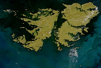
The Falkland Sound (Spanish : Estrecho de San Carlos) is a sea strait in the Falkland Islands. Running southwest-northeast, it separates West and East Falkland.

Contents

Name

The sound was named by John Strong in 1690 for Viscount Falkland, the name only later being applied to the archipelago and its two largest islands. The Spanish name "Estrecho de San Carlos" refers to the ship San Carlos which visited in 1768; confusingly the English name "San Carlos Water" is a much smaller inlet on East Falkland - and gives its name to San Carlos, Port San Carlos and the San Carlos River.

Captain John Strong of the Welfare made the first recorded landing on either of the main islands (West and East Falkland) on 29 January 1690, at Bold Cove (near Port Howard) just off Falkland Sound.

Geography

Islands in the Falkland Sound include Narrows Island, Great Island, the Tyssen Islands and the Swan Islands. Eddystone Rock is at the northern end of the Sound; the Arch Islands are at the southern end.

Settlements on it include Ajax Bay, New Haven, Port San Carlos, San Carlos on East Falkland and Port Howard and Fox Bay on West Falkland. A car ferry goes between Port Howard and New Haven.

Inlets and bays on the Sound include: Fox Bay, Port Howard (West Falkland); Grantham Sound, San Carlos Water, Ruggles Bay (East Falkland)

Geology

Folding of West Falkland - the Sound is parallel to the folds and would occupy the front left-hand corner of the diagram. FK2LMB.jpg
Folding of West Falkland - the Sound is parallel to the folds and would occupy the front left-hand corner of the diagram.
Folding of East Falkland Island - the Sound is at right angles to the folds and would occupy the front right-hand corner of the diagram. FK3LMB.jpg
Folding of East Falkland Island - the Sound is at right angles to the folds and would occupy the front right-hand corner of the diagram.

About 400 million years ago the land that became the Falkland Islands and Antarctica's Ellsworth Mountains, which had been part of Gondwana, broke from what is now Africa and drifted westwards relative to Africa. [1] During the mid-Jurassic period [2] (about 170 million years ago) the land fragment that was to become East Falkland and the land fragment that was to become West Falkland rotated about 120° relative to each other. As a result, the fold lines in West Falkland run almost south-west to north-east, parallel to the Sound. Those in the northern part of East Falkland run east-west, forming the eastern part of northern entrance to the Sound and bordering on the northern banks of San Carlos Water. The boundary between these two land fragments, the Falkland Sound Fault, lies close to and parallel with the western shore of the Sound. Lafonia (the southern half of East Falkland), which is a much newer formation, has no folds.

It is believed that at times during the Pleistocene era, the seabed was some 46 metres (151 ft) lower than the present timesufficient for the sound to be bridged. [3]

Records

On 21st January 2025, Esther Bertram of Stanley and Nuala Knight of Fox Bay swam across Falkland Sound, beginning from Fanning Head, East Falkland. The swimmers reached Jersey Point on West Falkland after 2 hours 37 minutes.

Related Research Articles

<span class="mw-page-title-main">Geography of the Falkland Islands</span>

The Falkland Islands are located in the South Atlantic Ocean between 51°S and 53°S on a projection of the Patagonian Shelf, part of the South American continental shelf. In ancient geological time this shelf was part of Gondwana, and around 400 million years ago split from what is now Africa and drifted westwards from it. Today the islands are subjected to the Roaring Forties, winds that shape both their geography and climate.

The Falkland Islands currently have three primary means of transport - road, sea and air. However, in 1946, when Sir Miles Clifford arrived as governor, there were no air services, no roads outside Stanley and an indifferent sea service. Sir Miles was instrumental in starting the Falkland Islands Government Air Service in December 1948. The inaugural flight involved a mercy flight from North Arm Settlement to Stanley to bring a girl with peritonitis to life-saving medical help in Stanley. There is now an international airport, a domestic airport, a number of airstrips, a growing road network and a much-improved ferry service between the two main islands.

<span class="mw-page-title-main">West Falkland</span> Island in Falkland Islands, Atlantic Ocean

West Falkland is the second largest of the Falkland Islands in the South Atlantic. It is a hilly island, separated from East Falkland by the Falkland Sound. Its area is 4,532 square kilometres, 37% of the total area of the islands. Its coastline is 1,258.7 kilometres long.

<span class="mw-page-title-main">East Falkland</span> Island in Falkland Islands, Atlantic Ocean

East Falkland is the largest island of the Falklands in the South Atlantic, having an area of 6,605 km2 or 54% of the total area of the Falklands. The island consists of two main land masses, of which the more southerly is known as Lafonia; it is joined by a narrow isthmus where the settlement of Goose Green is located, and it was the scene of the Battle of Goose Green during the Falklands War.

Port Howard is the largest settlement on West Falkland. It is in the east of the island, on an inlet of Falkland Sound. It is on the lower slopes of Mount Maria.

<span class="mw-page-title-main">Camp (Falkland Islands)</span>

The Camp is the term used in the Falkland Islands to refer to any part of the islands outside the islands' only significant town, Stanley, and often the large RAF base at Mount Pleasant. It is derived from the Spanish word campo, for "countryside".

<span class="mw-page-title-main">Port San Carlos</span> Port in East Falkland, Falkland Islands

Port San Carlos is located on the northern bank of the inlet known as Port San Carlos, off San Carlos Water on the Western coast of East Falkland, in the Falkland Islands. It is sometimes nicknamed "KC" after former owner Keith Cameron.

<span class="mw-page-title-main">Fox Bay</span> Place

Fox Bay is the second largest settlement on West Falkland in the Falkland Islands. It is located on a bay of the same name, and is on the south east coast of the island. It is often divided into Fox Bay East ("FBE") and Fox Bay West ("FBW") making it two settlements: combined, these make the largest settlement on West Falkland, but if separated, Port Howard is the largest. Fox Bay takes its name, like the Warrah River, from the Falkland fox, an animal locally called the warrah and now extinct.

<span class="mw-page-title-main">San Carlos Water</span> Bay on East Falkland

San Carlos Water is a bay/fjord on the west coast of East Falkland, facing onto the Falkland Sound.

Grantham Sound is a bay on East Falkland, Falkland Islands, which opens out into the Falkland Sound. At its landward end, it narrows and becomes Brenton Loch. Mount Usborne overlooks it.

<span class="mw-page-title-main">Ajax Bay</span> Place in Falkland Islands, United Kingdom

Ajax Bay is a settlement on East Falkland, in the Falkland Islands. It is on the north west coast, on the shore of San Carlos Water, a few miles from Port San Carlos. It was mainly a refrigeration plant, and was developed by the Colonial Development Corporation in the 1950s, which was also responsible for developing Port Albemarle. It was supposed to freeze Falkland mutton, but this was found to be economically unviable. Many of the pre-fabricated houses were moved to Stanley.

<span class="mw-page-title-main">Teal Inlet</span> Settlement on East Falkland in the Falkland Islands

Teal Inlet, once named Evelyn Station, is a settlement on East Falkland, in the Falkland Islands, on the south shore of Salvador Water. It is overshadowed by Jack's Mountain.

<span class="mw-page-title-main">Salvador Water</span>

Salvador Water or Port Salvador is a bay/inlet on the northeast coast of East Falkland, the largest of the Falkland Islands. It has an intricate shoreline, but could be described as being shaped like an "M".

<span class="mw-page-title-main">Foul Bay, Falkland Islands</span>

Foul Bay is an inlet on East Falkland island in the Falkland Islands. It is in the north west of the island, between Concordia Bay and San Carlos Water, and the northern end of Falkland Sound. It is also near Cape Dolphin.

Bold Cove is a small inlet on West Falkland near Port Howard on Falkland Sound, notable for its history. It runs parallel to the northern end of Port Howard, and Peake Ridge forms the west coast. It is approximately two miles long.

<span class="mw-page-title-main">Index of Falkland Islands–related articles</span>

Duplicate: List of Falkland Islands–related topics

<span class="mw-page-title-main">New Haven, Falkland Islands</span>

New Haven is an inlet in the Falkland Islands. It is situated on the west coast of East Falkland, facing Falkland Sound, the stretch of water which divides East Falkland from West Falkland. There is a colony of gentoo penguins.

References

  1. Otley H, Munro G, Clausen A, Ingham B (2008). "Falkland Islands - State of the Environment Report" (PDF). Falkland Islands Government and Falklands Conservation, Stanley. Archived from the original (PDF) on 20 July 2011. Retrieved 5 June 2010.
  2. P Stone, PC Richards, GS Kimbell, RP Esser, D Reeves (2008). "Cretaceous dykes discovered in the Falkland Islands: implications for regional tectonics in the South Atlantic". Journal of the Geological Society. 165 (1): 1–4. Bibcode:2008JGSoc.165....1S. doi:10.1144/0016-76492007-072. S2CID   129484422.
  3. Adie RJ (1953). New Evidence of Sea-level Changes in the Falkland Islands (Report). Falkland Island Dependency Survey, Colonial Office. Introduction. Scientific Report No 9. Archived from the original on 17 May 2013. Retrieved 17 May 2013.

51°48′S59°30′W / 51.800°S 59.500°W / -51.800; -59.500