List of settlements in the Falkland Islands

Last updated

This is a list of towns and settlements on the Falkland Islands .

Contents

Map of the Falkland Islands Falkland Islands topographic map-en.svg
Map of the Falkland Islands
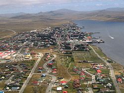
Stanley, Capital of the Falkland Islands Aerial photo Port Stanley.jpg
Stanley, Capital of the Falkland Islands
Goose Green Goose-Green.JPG
Goose Green

List

List of settlements by name, population, and island it is located on

#Settlement Island Population
1. Stanley East Falkland 2,108
2. Goose Green East Falkland40
3. Port Howard West Falkland 20

Unsorted

See also

Related Research Articles

History of the Falkland Islands

The history of the Falkland Islands goes back at least five hundred years, with active exploration and colonisation only taking place in the 18th century. Nonetheless, the Falkland Islands have been a matter of controversy, as they have been claimed by the French, British, Spaniards and Argentines at various points.

Geography of the Falkland Islands Geography of the Falkland Islands

The Falkland Islands are located in the South Atlantic Ocean between 51°S and 53°S on a projection of the Patagonian Shelf, part of the South American continental shelf. In ancient geological time this shelf was part of Gondwana, and around 400 million years ago split from what is now Africa and drifted westwards from it. Today the islands are subjected to the Roaring Forties, winds that shape both their geography and climate.

West Falkland Island in Falkland Islands, Atlantic Ocean

West Falkland is the second largest of the Falkland Islands in the South Atlantic. It is a hilly island, separated from East Falkland by the Falkland Sound. Its area is 4,532 square kilometres, 37% of the total area of the islands. Its coastline is 1,258.7 kilometres long.

East Falkland Island in Falkland Islands, Atlantic Ocean

East Falkland is the largest island of the Falklands in the South Atlantic, having an area of 6,605 km2 or 54% of the total area of the Falklands. The island consists of two main land masses, of which the more southerly is known as Lafonia; it is joined by a narrow isthmus where the settlement of Goose Green is located, and it was the scene of the Battle of Goose Green during the Falklands War.

Weddell Island Island in the Falkland Islands

Weddell Island is one of the Falkland Islands in the South Atlantic, lying off the southwest extremity of West Falkland. It is situated 1,545 km (960 mi) west-northwest of South Georgia Island, 1,165 km (724 mi) north of Livingston Island, 606 km (377 mi) northeast of Cape Horn, 358 km (222 mi) northeast of Isla de los Estados, and 510 km (320 mi) east of the Atlantic entrance to Magellan Strait.

Carcass Island Island in Falkland Islands

Carcass Island is the largest of the West Point Island Group of the Falkland Islands.

Lafonia

Lafonia is a peninsula forming the southern part of East Falkland, the largest of the Falkland Islands.

Falkland Sound

The Falkland Sound is a sea strait in the Falkland Islands. Running southwest-northeast, it separates West and East Falkland.

Camp (Falkland Islands)

The Camp is the term used in the Falkland Islands to refer to any part of the islands outside the islands' only significant town, Stanley, and often the large RAF base at Mount Pleasant. It is derived from the Spanish word campo, for "countryside".

Port Stanley Airport Civilian airport at Port Stanley, Falkland Islands

Port Stanley Airport is an airport in the Falkland Islands, two miles outside the capital, Stanley. The airport is the only civilian airport in the islands with a paved runway. However, RAF Mount Pleasant, located to the west of Stanley, functions as the islands' main international airport, because it has a long runway and allows civilian flights. Port Stanley Airport is operated by the Government of the Falkland Islands, and is used for internal flights between the islands and flights between the Falklands and Antarctica.

Port Egmont First British settlement on the Falkland Islands, established 1765

Port Egmont was the first British settlement in the Falkland Islands, on Saunders Island off West Falkland, and is named after the Earl of Egmont.

Index of Falkland Islands–related articles Wikipedia index

Duplicate: List of Falkland Islands-related topics

Weddell Settlement

Weddell Settlement is the only settlement on Weddell Island in the Falkland Islands, situated on the east coast of the island at the head of the sheltered Gull Harbour, part of Queen Charlotte Bay. It is located at 51°53′46″S60°54′27″W, which is 12.15 kilometres (7.55 mi) northeast of Race Point, 15 kilometres (9.3 mi) south by west of Swan Point, 212 kilometres (132 mi) west-southwest of Stanley and 56.6 kilometres (35.2 mi) west of Fox Bay on West Falkland.

Chatham Harbour, Weddell Island

Chatham Harbour is the large bay indenting the central part of Weddell Island in the Falkland Islands. It is entered east of Beacon Point and west of Loop Head. The 3 km wide bay extends 5 km in southeast direction, this part of the feature forming an anchorage named Bald Road, and north of Clay Point turning for 10 km in southwest direction. Chatham Harbour is centred at 51°50′16″S60°57′32″W.

Gull Harbour

Gull Harbour is the 1.3 km wide bay indenting for 2.8 km the east coast of Weddell Island in the Falkland Islands. It is entered north of Gull Point and south of Mark Point, and is centred at 51°53′56″S60°53′20″W. The principal settlement of the island, Weddell Settlement, is situated at the head of the bay. Until the mid-nineteenth century Gull Harbour was known as Great Harbour.