
The history of the Falkland Islands goes back at least five hundred years, with active exploration and colonisation only taking place in the 18th century. Nonetheless, the Falkland Islands have been a matter of controversy, as they have been claimed by the French, British, Spaniards and Argentines at various points.
The Falkland Islands currently has three primary means of transport - road, sea and air. However, in 1946, when Sir Miles Clifford arrived as governor, there were no air services, no roads outside Stanley and an indifferent sea service. Sir Miles was instrumental in starting the Falkland Islands Government Air Service in December 1948. The inaugural flight involved a mercy flight from North Arm Settlement to Stanley to bring a girl with peritonitis to life-saving medical help in Stanley. There is now an international airport, a domestic airport, a number of airstrips, a growing road network and a much-improved ferry service between the two main islands.

The Falklands War was a ten-week undeclared war between Argentina and the United Kingdom in 1982 over two British dependent territories in the South Atlantic: the Falkland Islands and its territorial dependency, South Georgia and the South Sandwich Islands. The conflict began on 2 April, when Argentina invaded and occupied the Falkland Islands, followed by the invasion of South Georgia the next day. On 5 April, the British government dispatched a naval task force to engage the Argentine Navy and Air Force before making an amphibious assault on the islands. The conflict lasted 74 days and ended with an Argentine surrender on 14 June, returning the islands to British control. In total, 649 Argentine military personnel, 255 British military personnel, and three Falkland Islanders were killed during the hostilities.

Stanley is the capital city of the Falkland Islands. It is located on the island of East Falkland, on a north-facing slope in one of the wettest parts of the islands. At the 2016 census, the city had a population of 2,460. The entire population of the Falkland Islands was 3,398 on Census Day on 9 October 2016.

West Falkland is the second largest of the Falkland Islands in the South Atlantic. It is a hilly island, separated from East Falkland by the Falkland Sound. Its area is 4,532 square kilometres, 37% of the total area of the islands. Its coastline is 1,258.7 kilometres long.

East Falkland is the largest island of the Falklands in the South Atlantic, having an area of 6,605 km2 or 54% of the total area of the Falklands. The island consists of two main land masses, of which the more southerly is known as Lafonia; it is joined by a narrow isthmus where the settlement of Goose Green is located, and it was the scene of the Battle of Goose Green during the Falklands War.

Weddell Island is one of the Falkland Islands in the South Atlantic, lying off the southwest extremity of West Falkland. It is situated 1,545 km (960 mi) west-northwest of South Georgia Island, 1,165 km (724 mi) north of Livingston Island, 606 km (377 mi) northeast of Cape Horn, 358 km (222 mi) northeast of Isla de los Estados, and 510 km (320 mi) east of the Atlantic entrance to Magellan Strait.

The Camp is the term used in the Falkland Islands to refer to any part of the islands outside the islands' only significant town, Stanley, and often the large RAF base at Mount Pleasant. It is derived from the Spanish word campo, for "countryside".

Port Stanley Airport is an airport in the Falkland Islands, two miles outside the capital, Stanley. The airport is the only civilian airport in the islands with a paved runway. However, RAF Mount Pleasant, located to the west of Stanley, functions as the islands' main international airport, because it has a long runway and allows civilian flights. Port Stanley Airport is operated by the Government of the Falkland Islands, and is used for internal flights between the islands and flights between the Falklands and Antarctica.

Puerto Soledad was a Spanish military outpost and penal colony on the Falkland Islands, situated at an inner cove of Berkeley Sound.

Yorke Bay is a bay on East Falkland in the Falkland Islands. It is located half a mile north of Port Stanley Airport, four miles to the northeast of the capital city of Stanley, on a peninsula connected to the mainland by the Boxer Bridge and a narrow isthmus known as "The Neck". Gypsy Cove is a smaller bay located on the west side of Yorke Bay. Most cruise ships pass Yorke Bay and Gypsy Cove on the way to dock in Stanley Harbour. It faces northwards into Port William, with Canopus Hill to the south, and is known internationally as a breeding site for the threatened Magellanic penguin.
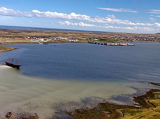
Stanley Harbour is a large inlet on the east coast of East Falkland island. A strait called "the Narrows" leads into Port William.

Salvador Water or Port Salvador is a bay/inlet on the northeast coast of East Falkland, the largest of the Falkland Islands. It has an intricate shoreline, but could be described as being shaped like an "M".

Duplicate: List of Falkland Islands-related topics
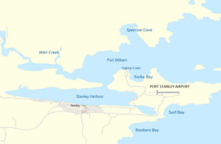
Blanco Bay is a bay located to the north of Stanley, Falkland Islands. It contains the Sparrow Cove. Gypsy Cove and the smaller Yorke Bay lie in its southern part to the northwest of Port Stanley Airport. A small channel passes through to the town of Port Stanley itself.
RAF Navy Point was a Royal Air Force base in the Falkland Islands. Set on a peninsula on which Canopus Hill, Stanley Airport and Gypsy Cove lie, together with a narrow spit of land known as Navy Point, which effectively divides Port William from Stanley Harbour. A small detachment of RAF SAR Helicopters of No. 1564 Flight RAF were based here until the Detachment was moved to RAF Mount Pleasant when the new base opened.

Chatham Harbour is the large bay indenting the central part of Weddell Island in the Falkland Islands. It is entered east of Beacon Point and west of Loop Head. The 3 km wide bay extends 5 km in southeast direction, this part of the feature forming an anchorage named Bald Road, and north of Clay Point turning for 10 km in southwest direction. Chatham Harbour is centred at 51°50′16″S60°57′32″W.


