Related Research Articles
Port Louis is a settlement on northeastern East Falkland. It was established by Louis de Bougainville on 5 April 1764 as the first French settlement on the islands, but was then transferred to Spain in 1767 and renamed Puerto Soledad.

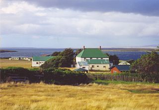
San Carlos is a settlement in northwestern East Falkland, lying south of Port San Carlos on San Carlos Water. It is sometimes nicknamed "JB" after a former owner, Jack Bonner. The settlement consists of a number of properties including a dwelling with a small cafe which also provides craft facilities. As noted in the history section, there is a small museum that pays homage to the Falklands Conflict as well as local nature and culture.

The Camp is the term used in the Falkland Islands to refer to any part of the islands outside the islands' only significant town, Stanley, and often the large RAF base at Mount Pleasant. It is derived from the Spanish word campo, for "countryside".

Port San Carlos is located on the northern bank of the inlet known as Port San Carlos, off San Carlos Water on the Western coast of East Falkland, in the Falkland Islands. It is sometimes nicknamed "KC" after former owner Keith Cameron.

Salvador Settlement, also called Salvador, Salvador Settlement Corral, is a small harbour and settlement on East Falkland, in the Falkland Islands, It is on the north east coast, on the south shore of Port Salvador. It is one of a handful of Spanish place names on the islands, still in use.


Puerto Soledad was a Spanish military outpost and penal colony on the Falkland Islands, situated at an inner cove of Berkeley Sound.


Johnson's Harbour is a settlement on the north east coast of East Falkland in the Falkland Islands. It is on the shore of Berkeley Sound at the head of Chabot Creek on a bay also named Johnson's Harbour. It has a small store but the FIGAS only lands there for emergencies. Surrounding hills include North Lookout, Diamond Mountain and Hawk Hill.
Green Patch is a settlement on East Falkland, in the Falkland Islands, It is on the north east coast, on the south shore of Berkeley Sound, a few miles south east from Port Louis, on Port Louis Harbour. It looks out onto Long Island and Hog Island.
Teal Inlet, once named Evelyn Station, is a settlement on East Falkland, in the Falkland Islands, on the south shore of Salvador Water. It is overshadowed by Jack's Mountain.

Fitzroy is a settlement on East Falkland. It is divided into Fitzroy North and Fitzroy South by a tidal river called Fitzroy River that is fed from a lake on the east side of Mount Whickham. The river was forded by Charles Darwin when he visited for a second time in 1834.

Salvador Water or Port Salvador is a bay/inlet on the northeast coast of East Falkland, the largest of the Falkland Islands. It has an intricate shoreline, but could be described as being shaped like an "M".
Cape Bougainville is the second-most northerly point on East Falkland, Falkland Islands, after Cape Dolphin, and is the second-most northerly point of the two main islands, East and West Falkland. Many of the smaller islands, such as the Jason Islands, are further north.

Mare Harbour, known colloquially as East Cove Port, is a small settlement on East Falkland, on Choiseul Sound. It is mostly used as a port facility and depot for RAF Mount Pleasant, as well as a deepwater port used by the Royal Navy ships patrolling the South Atlantic and Antarctica, which means that the main harbour of the islands, Stanley Harbour tends to deal with commercial transport.
The Malo River, is a river in East Falkland, Falkland Islands. Its name is derived from the Breton port of St Malo, due to the French settlement established at Port Louis in 1764.
Seal Bay is a bay, about 1 km across, on the rugged and exposed north coast of East Falkland in the Falkland Islands of the South Atlantic Ocean. It lies some 40 km north-west of Stanley.

Weddell Settlement is the only settlement on Weddell Island in the Falkland Islands, situated on the east coast of the island at the head of the sheltered Gull Harbour, part of Queen Charlotte Bay. It is located at 51°53′46″S60°54′27″W, which is 12.15 kilometres (7.55 mi) northeast of Race Point, 15 kilometres (9.3 mi) south by west of Swan Point, 212 kilometres (132 mi) west-southwest of Stanley and 56.6 kilometres (35.2 mi) west of Fox Bay on West Falkland.
Gull Harbour is the 1.3 km wide bay indenting for 2.8 km the east coast of Weddell Island in the Falkland Islands. It is entered north of Gull Point and south of Mark Point, and is centred at 51°53′56″S60°53′20″W. The principal settlement of the island, Weddell Settlement, is situated at the head of the bay. Until the mid-nineteenth century Gull Harbour was known as Great Harbour.
References
51°27′33″S58°36′30″W / 51.4593°S 58.6082°W
| | This Falkland Islands location article is a stub. You can help Wikipedia by expanding it. |