
The Falkland Islands are located in the South Atlantic Ocean between 51°S and 53°S on a projection of the Patagonian Shelf, part of the South American continental shelf. In ancient geological time this shelf was part of Gondwana, and around 400 million years ago split from what is now Africa and drifted westwards from it. Today the islands are subjected to the Roaring Forties, winds that shape both their geography and climate.
The Falkland Islands currently has three primary means of transport - road, sea and air. However, in 1946, when Sir Miles Clifford arrived as governor, there were no air services, no roads outside Stanley and an indifferent sea service. Sir Miles was instrumental in starting the Falkland Islands Government Air Service in December 1948. The inaugural flight involved a mercy flight from North Arm Settlement to Stanley to bring a girl with peritonitis to life-saving medical help in Stanley. There are now an international airport, a domestic airport, a number of airstrips, a growing road network and a much-improved ferry service between the two main islands.

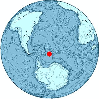
South Georgia and the South Sandwich Islands (SGSSI) is a British Overseas Territory in the southern Atlantic Ocean. It is a remote and inhospitable collection of islands, consisting of South Georgia and a chain of smaller islands known as the South Sandwich Islands. South Georgia is 165 kilometres (103 mi) long and 35 kilometres (22 mi) wide and is by far the largest island in the territory. The South Sandwich Islands lie about 700 kilometres (430 mi) southeast of South Georgia. The territory's total land area is 3,903 km2 (1,507 sq mi). The Falkland Islands are about 1,300 kilometres (810 mi) north-west from its nearest point.

Carcass Island is the largest of the West Point Island Group of the Falkland Islands.

The Jason Islands are an archipelago in the Falkland Islands, lying to the far north-west of West Falkland. Three of the islands, Steeple Jason, Grand Jason and Clarke's Islet, are private nature reserves owned by the Wildlife Conservation Society of New York City. Other islands in the group are National Nature Reserves owned by the Falkland Islands Government.

Sea Lion Island is the largest of the Sea Lion Island Group of the Falkland Islands. It is 9 km2 (3 sq mi) in area. and lies 14 km (9 mi) southeast of Lafonia. It was designated a Ramsar site on 24 September 2001., and as an Important Bird Area. In 2017 the island was designated as a National Nature Reserve.

Beauchene Island is the southernmost of the Falkland Islands, lying about 54 kilometres (34 mi) south of Porpoise Point in Lafonia. It was discovered in 1701 by Jacques Gouin de Beauchêne, after whom it was named.
Thule Island, also called Morrell Island, is one of the southernmost of the South Sandwich Islands, part of the grouping known as Southern Thule. It is named, on account of its remote location, after the mythical land of Thule, said by ancient geographers to lie at the extreme end of the Earth. The alternative name Morrell Island is after Benjamin Morrell, an American explorer and whaling captain. It was espied by James Cook and his Resolution crew on 31 January 1775 during his attempt to find Terra Australis.
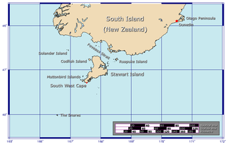
Ruapuke Island is one of the southernmost islands in New Zealand's main chain of islands. It lies 15 kilometres (9.3 mi) to the southeast of Bluff and 32 kilometres (20 mi) northeast of Oban on Stewart Island/Rakiura. It was named "Bench Island" upon its European discovery by Captain James Cook in 1770, but has rarely been known by any other name than its Māori name, which means "two hills". The island covers an area of about 16 km2 (6 sq mi). It guards the eastern end of Foveaux Strait.

The geology of the Falkland Islands is described in several publications. The Falkland Islands are located on a projection of the Patagonian continental shelf. In ancient geological time this shelf was part of Gondwana, which around 400 million years ago broke from what is now Africa and drifted westwards relative to Africa. Studies of the seabed surrounding the islands indicated the possibility of oil. Intensive exploration began in 1996, although there had been some earlier seismic surveys in the region.

Rossel Island is the easternmost island of the Louisiade Archipelago, which itself is part of the Milne Bay Province of Papua New Guinea. Tree Islet is situated 1.5 miles (2.4 km) to the north-west, while Wule Island is situated 1.5 miles (2.4 km) westward.

The Passage Islands are a group of four islands in the Falkland Islands of the South Atlantic Ocean. They lie off Dunnose Head, West Falkland, at the mouth of King George Bay.

San Carlos Water is a bay/fjord on the west coast of East Falkland, facing onto the Falkland Sound.

The Argentine Sea is the sea within the continental shelf off the Argentine mainland.

Middle Island is one of the Hummock Island group in the Falkland Islands. It is near West Falkland, to its west, near the estuary of the Chartres River in King George Bay It is to the south east of Hummock Island.
Hummock Island is the largest of a group of islands in King George Bay in the Falkland Islands. It has a land area of 3.03 square kilometres (1.17 sq mi) and is about 4.0 miles (6.4 km) long in a north-west to south-east direction. Hummock Island is off the western coast of West Falkland, in a bay that leads to the estuary of the Chartres River. The highest point on the island is in the north-east and is 190 metres (620 ft). There are cliffs which often reach over 60 metres (200 ft) high.

Shambles Glacier is a steep glacier 4 miles long and 6 miles wide, with very prominent hummocks and crevasses, flowing east between Mount Bouvier and Mount Mangin into Stonehouse Bay on the east side of Adelaide Island. It is the island's largest glacier, and provides an eastern outlet from the giant Fuchs Ice Piedmont which covers the entire western two-thirds of the island. In doing so, Shambles Glacier provides the largest 'gap' in Adelaide Island's north-south running mountain chain.
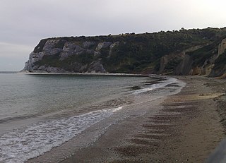
Whitecliff Bay is a sandy bay near Foreland which is the easternmost point of the Isle of Wight, England about two miles south-west of Bembridge and just to the north of Culver Down. The bay has as a shorline of around three-quarters of a mile (1.2 km) and has a popular sandy shingle beach which is over half a mile long. It is a tourist site with three holiday parks in the vicinity of the bay, it has two cafes though minimal facilities. Access is limited and only possible down two steeply sloping concrete tracks.

Mount Weddell is the summit of Weddell Island in the Falkland Islands. The mountain rises to 383 metres (1,257 ft) and is situated 8 km northeast of Race Point, 9.8 km east of Pillar Bluff, 4.35 km southwest of Weddell Settlement and 4.6 km west-northwest of Circum Point.


