The Prince Albert Mountains are a major mountain group in Antarctica over 320 km (200 mi) long. Located in Victoria Land, they run north–south between the Priestley and Ferrar glaciers.
Jason Peak is a peak, 675 metres (2,215 ft) high, lying 1 mile (1.6 km) west of Jason Harbour on the north coast of South Georgia. The name appears to be first used on a 1929 British Admiralty chart.
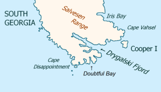
Drygalski Fjord is a bay 1 mile (1.6 km) wide which recedes northwestwards 7 miles (11 km), entered immediately north of Nattriss Head along the southeast coast of South Georgia. It was charted by the Second German Antarctic Expedition, 1911–12, under Wilhelm Filchner, and named for Professor Erich von Drygalski, the leader of the First German Antarctica Expedition, 1901–03.
Crean Glacier is a glacier 4 miles (6.4 km) long, flowing northwest from Wilckens Peaks to the head of Antarctic Bay on the north coast of South Georgia. It was surveyed by the South Georgia Survey in the period 1951–57 and named by the UK Antarctic Place-Names Committee for Irishman Tom Crean, Second Officer of the Endurance during the British expedition under Ernest Shackleton, 1914–16. Crean accompanied Shackleton and Frank Worsley in the James Caird from Elephant Island to King Haakon Bay, South Georgia, and made the overland crossing with them to Stromness; this glacier lies on the route.
Mount Worsley is a mountain, 1,105 m, on the west side of Briggs Glacier in South Georgia. It was surveyed by the South Georgia Survey in the period 1951–57, and named by the United Kingdom Antarctic Place-Names Committee (UK-APC) for Frank Arthur Worsley (1872–1943), skipper of the Endurance on 1914-16 Imperial Trans-Antarctic Expedition. Worsley accompanied Ernest Shackleton in the James Caird from Elephant Island to King Haakon Bay, South Georgia, and made the overland crossing with him to Stromness whaling station.
Helland Glacier is a glacier 4 nautical miles (7 km) long flowing southwest from Mount Paget to Rocky Bay, on the south side of South Georgia. It was mapped by Olaf Holtedahl during his visit to South Georgia in 1927–28, and named by him for Amund Helland, a Norwegian mining geologist and glaciologist.

Cadman Glacier is a glacier, 1.5 nautical miles (3 km) wide at its mouth and about 7 nautical miles (13 km) long, flowing northwestward into the head of the southern arm of Beascochea Bay south of Plas Point on the west side of the Antarctic Peninsula.

Usher Glacier is a glacier nearly 4 nautical miles (7 km) long, flowing northwest into the sea between Stigant Point and Davey Point on the north coast of King George Island, in the South Shetland Islands. Named by the United Kingdom Antarctic Place-Names Committee (UK-APC) in 1960 for J. Usher, Master of the Caraquet from Liverpool, who visited the South Shetland Islands in 1821–22.
Delius Glacier is a glacier, 6 nautical miles (11 km) long and 2 nautical miles (4 km) wide, flowing west from the Elgar Uplands into Nichols Snowfield, in the northern part of Alexander Island, Antarctica. It was first seen from the air and roughly mapped by the British Graham Land Expedition in 1937. It was more accurately mapped from air photos taken by the Ronne Antarctic Research Expedition, 1947–48, by D. Searle of the Falkland Islands Dependencies Survey in 1960, and from U.S. Landsat imagery of February 1975. It was named by the UK Antarctic Place-Names Committee after Frederick Delius, the British composer.
Fulmar Bay is a bay 1 nautical mile (2 km) wide between Moreton Point and Return Point at the west end of Coronation Island, in the South Orkney Islands. It was first sighted and roughly charted by Captain George Powell and Captain Nathaniel Palmer on their joint cruise in December 1821. It was surveyed in 1933 by Discovery Investigations personnel, and so named in 1954 by the UK Antarctic Place-Names Committee because large numbers of Antarctic Fulmars nest in this area.
Perkins Glacier is a broad, low gradient glacier 8 nautical miles (15 km) south-southeast of Cape Burks on the coast of Marie Byrd Land. It drains west from McDonald Heights into the east side of Hull Bay. Mapped by United States Geological Survey (USGS) from surveys and U.S. Navy air photos, 1959–65. Named by Advisory Committee on Antarctic Names (US-ACAN) for Earle B. Perkins, biologist with the Byrd Antarctic Expedition, 1933–35.
Meridian Glacier is a broad glacier, 9 nautical miles (17 km) long, which flows south along the west side of Godfrey Upland and joins Clarke Glacier between Behaim Peak and Elton Hill, in southern Graham Land, Antarctica. Finn Ronne and Carl R. Eklund of the United States Antarctic Service travelled along this glacier in January 1941. It was photographed from the air by the Ronne Antarctic Research Expedition in November 1947, and was surveyed by the Falkland Islands Dependencies Survey in December 1958. The glacier was so named by the UK Antarctic Place-Names Committee because the glacier flows from north to south along the meridian.
Hall Cliff is a sandstone cliff 1 nautical mile (2 km) long, located along the south side of Saturn Glacier and 1 nautical mile west of Citadel Bastion in eastern Alexander Island, Antarctica. The feature was mapped from trimetrogon air photography taken by the Ronne Antarctic Research Expedition, 1947–48, and from survey by the Falkland Islands Dependencies Survey, 1948–50. It was named by the UK Antarctic Place-Names Committee from association with Saturn Glacier after Asaph Hall, the American astronomer who contributed toward the study of Saturn and also discovered the satellites of the planet Mars.
Hansen Island is an island 6 nautical miles (11 km) long and 3 nautical miles (6 km) wide, lying immediately north of The Gullet at the head of Hanusse Bay, off the west coast of Graham Land, Antarctica. It was first surveyed in 1936 by the British Graham Land Expedition (BGLE) under John Rymill, who used the provisional name "North Island" for this feature. The island was resurveyed in 1948 by the Falkland Islands Dependencies Survey, and was renamed in 1954 by the UK Antarctic Place-Names Committee for Leganger H. Hansen, manager at Messrs. Christian Salvesen's whaling station at Leith Harbor, South Georgia, 1916–37, who gave great assistance to the BGLE, 1934–37.
McCarthy Island is an island, 1 nautical mile (2 km) long, lying in the entrance to King Haakon Bay on the south side of South Georgia. It was surveyed by the South Georgia Survey in the period 1951–57, and was named by the UK Antarctic Place-Names Committee after Timothy McCarthy, a seaman on the Endurance during the British expedition under Ernest Shackleton, 1914–16. McCarthy accompanied Shackleton in the James Caird from Elephant Island to King Haakon Bay.
Kanin Point is a rocky point lying 2 nautical miles (4 km) west-southwest of Kelp Point on the south side of Husvik Harbor, in Stromness Bay, South Georgia. The descriptive name "Rocky Point" was given for this feature, probably by Discovery Investigations personnel who surveyed Husvik Harbor in 1928, but this name is used elsewhere in the Antarctic. The South Georgia Survey, 1951–52, reported that this feature is known at the Husvik whaling station as Kanin Point. The name presumably arose from one of several attempts made since 1872 to introduce rabbits into the island. Kanin Point is approved on the basis of local usage.

Rush Glacier is a glacier in Antarctica. Situated in southern Brabant Island, it is 4 nautical miles (7 km) long, draining the northwest slopes of Solvay Mountains and flowing west between Mount Aciar and Mount Sarnegor into the Buragara Cove of Dallmann Bay in the Palmer Archipelago. It was shown on an Argentine government chart in 1953, but not named. It was photographed by Hunting Aerosurveys Ltd in 1956–57, and mapped from these photos in 1959. The glacier was named by the United Kingdom Antarctic Place-Names Committee (UK-APC) for Benjamin Rush (1745–1813), a noted American physician and philanthropist, and a signatory of the Declaration of Independence.
Rigsby Islands is a small group of ice-capped islands lying off the northeast coast of Adelaide Island, about 2 nautical miles (3.7 km) south of Sillard Islands. Mapped from air photos taken by Ronne Antarctic Research Expedition (RARE) (1947–48) and Falkland Islands and Dependencies Aerial Survey Expedition (FIDASE) (1956–57). Named by United Kingdom Antarctic Place-Names Committee (UK-APC) for George P. Rigsby, American geologist who has specialized in the investigation of ice crystal structure and the plasticity of ice.

Rochray Glacier is a glacier about 5 nautical miles (9 km) long, located just east of Hendersin Knob on Thurston Island and flowing south to Abbot Ice Shelf in Peacock Sound. First delineated from air photos taken by U.S. Navy Operation Highjump in December 1946. Named by Advisory Committee on Antarctic Names (US-ACAN) for Lieutenant (j.g.) Samuel Rochray, U.S. Navy, helicopter pilot on USS Glacier in February 1960, who made several flights in which new parts of Thurston Island were discovered. Jordan Nunatak stands between Rochray and Cox Glacier.
