
Guayaquil, officially Santiago de Guayaquil, is the second largest city in Ecuador. It is also the nation's main port. The city is the capital of Guayas Province and the seat of Guayaquil Canton.

Esmeraldas is a province in northwestern Ecuador. The capital is Esmeraldas.
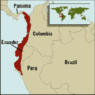
Tumbes-Chocó-Magdalena is a biodiversity hotspot, which includes the tropical moist forests and tropical dry forests of the Pacific coast of South America and the Galapagos Islands. The region extends from easternmost Panama to the lower Magdalena Valley of Colombia, and along the Pacific coast of Colombia and Ecuador to the northwestern corner of Peru. Formerly called the Chocó-Darién-Western Ecuador Hotspot, it has been expanded to include several new areas, notably the Magdalena Valley in northern Colombia. It is bounded on the east by the Andes Mountains. The Tumbes-Choco-Magdalena Hotspot is 1,500 km long and encircles 274,597 km². Tumbes-Choco-Magdalena is near the Pacific Ocean. The factors that threaten Tumbes-Choco-Magdalena are farming encroachment, deforestation, illegal crops, and population growth. Whereas the Panamanian and Colombian portion of the hotspot are relatively intact, approximately 98% of native forest in coastal Ecuador has been cleared, rendering it the most threatened tropical forest in the world. The hotspot includes a wide variety of habitats, ranging from mangroves, beaches, rocky shorelines, and coastal wilderness to some of the world's wettest rain forests in the Colombian Chocó. The hotspot includes a number of ecoregions:

Esmeraldas is a coastal city in northwestern Ecuador. It is the seat of the Esmeraldas Canton and capital of the Esmeraldas Province. It has an international sea port and a small airport. Esmeraldas is the major seaport of northwestern Ecuador, and it lies on the Pacific coast at the mouth of the Esmeraldas River. It is exactly at the antipodes of Padang, Indonesia. The city is the principal trading hub for the region's agricultural and lumber resources, and is the terminus of the 313-mile (504-km) Trans-Ecuadorian Pipeline from the oil fields in northeastern Ecuador.

The Gulf of Guayaquil–Tumbes mangroves (NT1413) are an ecoregion located in the Gulf of Guayaquil in South America, in northern Peru and southern Ecuador. It has an area of 3,300 km².

The Esmeraldas River is a 210 kilometers river in northwestern Ecuador that flows into the Pacific Ocean at the city of Esmeraldas. Among its tributaries is the Guayllabamba River which drains Quito. Charles Marie de la Condamine sailed up it and then climbed the Andes Mountains when on the Ecuadorian Expedition that left France in May 1735.
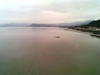
Muisne is a coastal town in the southwest of the province of Esmeraldas in northwestern Ecuador, with 5,925 inhabitants in the last Ecuadorian census in 2010. It is the seat of the namesake canton.

Cynthia Fernanda Viteri Jiménez de Villamar is an Ecuadorian lawyer, journalist and politician. On March 24, 2019, she was elected Mayor of Guayaquil, the largest city in Ecuador, in the sectional elections of Ecuador for a term from May 14, 2019 until May 14, 2024. She was the presidential candidate for Partido Social Cristiano in the 2017 presidential elections, and was a candidate in the 2006 presidential elections of Ecuador and finished fifth. Between 1998 and 2007 she was a member of the National Congress. In 2009 she became a member of the National Assembly.
The Congal Biomarine Station is a protected nature reserve created in 2000 and is located in southwestern Esmeraldas Province, close to the town of Muisne in northwestern Ecuador. The Congal Reserve is managed by the Jatun Sacha Foundation and features beach, estuarine, mangrove, wetlands and humid tropical forest habitats, accounting for the region's high biodiversity and local endemism. The station was founded by the Quiroga family in partnership with conservationist, Arlo Hemphill.
Hyloxalus pulchellus is a species of frog in the family Dendrobatidae from northern Ecuador and southern Colombia. Colombina source does not include Nariño but does include Putumayo Department.
Global mangrove distributions have fluctuated throughout human and geological history. The area covered by mangroves is influenced by a complex interaction between land position, rainfall hydrology, sea level, sedimentation, subsidence, storms and pest-predator relationships). In the last 50 years, human activities have strongly affected mangrove distributions, resulting in declines or expansions of worldwide mangrove area. Mangroves provide several important ‘free services’ including coastal stabilization, juvenile fish habitats, and the filtration of sediment and nutrients). Mangrove loss has important implications for coastal ecological systems and human communities dependent on healthy mangrove ecosystems. This English Wikipedia page presents an overview of global mangrove forest biome trends in mangrove ecoregions distribution, as well as the cause of such changes.

Danilo Xavier Carrera Huerta, known as Danilo Carrera is an Ecuadorian actor, presenter and model.

The Western Ecuador Moist Forests (NT0178), also known as the Pacific Forest of Ecuador, is an ecoregion in the plains and western foothills of the Andes of southern Colombia and Ecuador. At one time this region contained dense forests with highly diverse flora and fauna, and many endemic species. Most of the original habitat has now been destroyed, and the ecoregion is one of the most threatened in the world.

The South American Pacific mangroves, or Panama Bight mangroves, is an ecoregion along the Pacific coast of Panama, Colombia, Ecuador and Peru.
The Esmeraldas-Pacific Colombia mangroves (NT1409) is an ecoregion of mangrove forests along the Pacific coast of Colombia and Ecuador. It is threatened by human population growth, leading to over-exploitation for wood and clearance for farming and aquaculture.
The Manabí mangroves (NT1418) is an ecoregion along the Pacific coast of Ecuador. The mangroves serve important functions in the marine and terrestrial ecology. They have been severely degraded and fragmented, particularly in the northern region. Construction of shrimp farms caused much damage in the past, but is now banned. Sedimentation caused by overgrazing in higher lands is an issue, as are human activities such as port and highway construction, urbanization, waste disposal and so on.

The Mache River is a river that enters the Pacific Ocean through the Cojimies Estuary on the north coast of Ecuador.

The Ensenada de Mompiche is a bay on the Pacific coast of northern Ecuador.

The Mache-Chindul Ecological Reserve is an ecological reserve in the provinces of Esmeraldas and Manabí, Ecuador. It protects a mountainous area in the transition from tropical rain forest in the north to dry forest in the south. It contains the Cube Lagoon, which has been designated a Ramsar wetland of international importance.
