Matagorda Peninsula Army Airfield

Last updated

Matagorda Peninsula Army Airfield
Near Matagorda Island, Texas
Matagorda Army Airfield - TX.jpg
March 1943 photo showing over 100 aircraft on the Matagorda Peninsula AAF ramp.
USA Texas location map.svg
Red pog.svg
Matagorda Peninsula Army Airfield
Location of Matagorda Army Airfield
Coordinates 28°27′17″N096°17′54″W / 28.45472°N 96.29833°W / 28.45472; -96.29833
Site information
ConditionAbandoned
Site history
Built1942 (1942)
In use1942-1945
Battles/wars World War II
Garrison information
Garrison Us army air corps shield.svg   United States Army Air Forces
OccupantsAAF Pilot School (Advanced Single Engine Transition)
77th Flying Training Wing
Airfield information
Runways
Direction Length and surface
01L/19R4,000' x 150' (closed)  Asphalt
01R/19L4,000' x 150' (closed)  Asphalt
05/234,000' x 150' (closed)  Asphalt
14L/22R4,000' x 150' (emergency only)  Asphalt
14R/22L4,000' x 150' (closed)  Asphalt

Matagorda Peninsula Army Airfield is a closed military airfield, located on Matagorda Island, Texas. It was used during World War II as a training airfield by the 77th Flying Training Wing, Army Air Forces Central Flying Training Command.

Contents

History

World War II

The airfield was built during 1942 by the Army Air Corps, primarily to support the Matagorda Bombing Range. In addition it was also developed as a training school by Army Air Forces Training Command. Matagorda AAF was the home of the AAF Pilot School (Advanced Single Engine), and also conducted a Single-Engine Pilot Transition school. [1] The major military units assigned were the 62d Single Engine Flying Training Group and 79th Bombardier Training Group. [2]

Initially built with three runways, during the war two additional runways were added to accommodate the large number of landings and takeoffs. Aircraft assigned to the base were North American AT-6 Texans, Curtiss P-40 Warhawks, Republic P-47 Thunderbolts, and North American P-51 Mustangs. [3] A series of curved roads on the east side of the parking ramp had dozens of buildings. After the war ended, the training school was inactivated and the facility was closed in November 1945. [1]

Conestoga I prepared for launch Conestoga I prepared for launch.jpg
Conestoga I prepared for launch

Civil use

After the war ended, the airfield was transferred to civil control, and was known as Matagorda Peninsula Airport.

In the late 1940s, the National Advisory Committee for Aeronautics considered Matagorda Island as a rocket launch site, however Cape Canaveral, Florida was chosen instead.

In the 1980s, a private firm, Space Services, Inc. of America (SSIA), established a rocket launch facility on the island for commercial rockets with the airport, known as Pierce Field, providing aircraft access. [1]

However SSIA only ever conducted two rocket tests at this facility. The first was of their Percheron rocket which exploded on the pad during an engine test firing on 5 August 1981, and then a single successful launch of their Conestoga I on 9 September 1982, which became the first privately funded rocket to reach space. [4]

The airfield remained active until about 2002 when SSIA ended its use of Matagorda Island, and the airport was closed and abandoned. [1]

Today, the airport is closed and its facilities are deteriorating. Some old rocket launch stands can be found in the area. The World War II military base was dismantled and no longer remains.

See also

Related Research Articles

<span class="mw-page-title-main">Waco Regional Airport</span> Airport in Texas

Waco Regional Airport is an airport in Waco, McLennan County, Texas. It is owned by the City of Waco.

<span class="mw-page-title-main">Foster Air Force Base</span> Former USAF facility in Victoria County, Texas

Foster Air Force Base is a former United States Air Force facility in Texas, located in Victoria County, approximately six miles (10 km) east-northeast of Victoria.

<span class="mw-page-title-main">Walker Air Force Base</span> U.S. Air Force base near Roswell, New Mexico

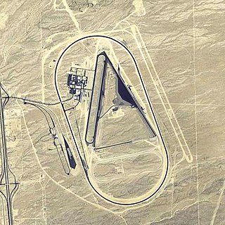
Walker Air Force Base is a closed United States Air Force base located three miles (5 km) south of the central business district of Roswell, New Mexico. It was opened in 1941 as an Army Air Corps flying school and was active during World War II and the postwar era as Roswell Army Air Field (RAAF). During the early years of the Cold War, it became the largest base of the Strategic Air Command. It is also known for the Roswell UFO incident, an event that occurred on 4 July 1947. It is alleged that a "flying disc" crashed during a severe thunderstorm near the base at Corona, New Mexico.

<span class="mw-page-title-main">Craig Air Force Base</span>

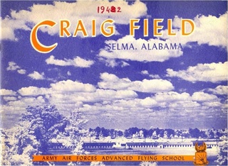
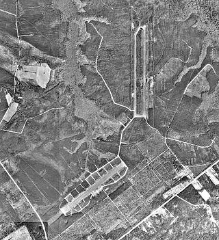
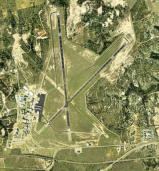
Craig Air Force Base near Selma, Alabama, was a U.S. Air Force undergraduate pilot training (UPT) installation that closed in 1977. Today the facility is a civilian airport known as Craig Field Airport and Industrial Complex.

<span class="mw-page-title-main">Marine Corps Outlying Field Camp Davis</span> Airport in near Holly Ridge, North Carolina

Marine Corps Outlying Field (MCOLF) Camp Davis is a military use airport northeast of the central business district of Holly Ridge, in Onslow County, North Carolina, United States. It is used as a training facility by the United States Marines of Camp Lejeune and Marine Corps Air Station New River.

<span class="mw-page-title-main">Sharpe Field</span> Airport in Tuskegee, Alabama

Sharpe Field is a closed private use airport located six nautical miles northwest of the central business district of Tuskegee, a city in Macon County, Alabama, United States. This airport is privately owned by the Bradbury Family Partnership.

<span class="mw-page-title-main">Aloe Army Airfield</span> Airfield in Victoria County, Texas

Aloe Army Airfield is an abandoned airfield located 7 miles (11 km) west of Victoria, Texas.

<span class="mw-page-title-main">Avenger Field</span> Airport in Texas, United States of America

Avenger Field is a Texas airport in Nolan County, three miles west of Sweetwater. The National Plan of Integrated Airport Systems for 2011–2015 called it a general aviation facility.

<span class="mw-page-title-main">Matagorda Island Air Force Base</span>

Matagorda Island Air Force Base is a closed military airfield on the north end of Matagorda Island, northeast of Corpus Christi, Texas. It was closed by the United States Air Force in 1975.

<span class="mw-page-title-main">Coolidge Municipal Airport</span> Airport in Pinal County, Arizona

Coolidge Municipal Airport is a city-owned public airport 5 miles southeast of Coolidge, in Pinal County, Arizona, United States.

<span class="mw-page-title-main">Dateland Air Force Auxiliary Field</span> Abandoned military airfield in Yuma County, Arizona

Dateland Air Force Auxiliary Field is an abandoned military airfield located in Dateland, Arizona, 40 miles (64 km) east of Yuma, Arizona. Its last known military use was in 1957.

<span class="mw-page-title-main">Yucca Army Airfield</span> Former airfield in Mohave County, Arizona

Yucca Army Airfield is a former military airfield located about 1 mile (1.6 km) west of Yucca, in Mohave County, Arizona, United States. It is on the east side of Interstate 40, 25 miles (40 km) south of Kingman. It is now used as a private facility owned by Fiat Chrysler Automobiles named Chrysler Arizona Proving Grounds.

<span class="mw-page-title-main">Graham Air Base</span> Airport in Florida, U.S.

Graham Air Base was a United States Air Force base located in Marianna, Florida. After it was closed in 1960, it was reused as Marianna Municipal Airport.

<span class="mw-page-title-main">Dalhart Army Air Base</span> Airport

Dalhart Army Air Base is a former World War II military airfield complex near the city of Dalhart, Texas. It operated three training sites for the United States Army Air Forces from 1943 until 1945.

<span class="mw-page-title-main">Stuttgart Army Air Field (Arkansas)</span> Former airfield in Arkansas, United States

Stuttgart Army Airfield is a former World War II military airfield, located 7 miles north of Stuttgart, Arkansas. It operated as an advanced pilot training school for the United States Army Air Forces from 1942 until 1945.

<span class="mw-page-title-main">Grand Island Army Air Field</span> Operating 1942 to 1946

Grand Island Army Airfield was a United States Army Air Forces airfield which operated from 1942 to 1946. After its closure, the base was reopened as Central Nebraska Regional Airport.

<span class="mw-page-title-main">San Angelo Army Air Field</span> World War II Army air field in Texas

San Angelo Army Airfield is an inactive United States Air Force base, about 8 miles south-southwest of San Angelo, Texas. It was active during World War II as a training airfield. It was closed on 30 November 1945.

<span class="mw-page-title-main">Freeman Army Airfield</span> Former US military facility

Freeman Army Airfield is an inactive United States Army Air Forces base located in2.6 miles (4.2 km) south-southwest of Seymour, Indiana.

<span class="mw-page-title-main">Eagle Pass Army Airfield</span> World War II US military installation

Eagle Pass Army Airfield is a former World War II military airfield complex. It is located 10.6 miles (17.1 km) north of Eagle Pass, Texas. It operated as a training base for the United States Army Air Forces from 1943 until 1945.

<span class="mw-page-title-main">77th Flying Training Wing</span> Military unit

The 77th Flying Training Wing was a wing of the United States Army Air Forces. It was assigned to the Central Flying Training Command, and was based in Texas between 1943 and its disbandment on 16 June 1946.

References

Notes

  1. 1 2 3 4 "Abandoned & Little-Known Airfields: Texas, Northeastern Corpus Christi area". Archived from the original on 21 March 2014. Retrieved 20 March 2014.
  2. 77th Flying Training Wing, lineage and history document Air Force Historical Agency, Maxwell AFB, Alabama
  3. www.accident-report.com: Matagorda Peninsula Bombing Range Archived 2014-10-08 at the Wayback Machine
  4. Abell, John C. (9 September 2009). "Sept. 9, 1982: 3-2-1 … Liftoff! The First Private Rocket Launch". Wired.

Sources