Related Research Articles
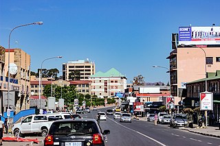
Maseru is the capital and largest city of Lesotho. It is also the capital of the Maseru District. Located on the Caledon River, Maseru lies directly on the Lesotho–South Africa border. Maseru had a population of 330,760 in the 2016 census. The city was established as a police camp and assigned as the capital after the country became a British protectorate in 1869. When the country achieved independence in 1966, Maseru retained its status as capital. The name of the city is a Sesotho word meaning "red sandstones".

The National University of Lesotho, the main and oldest university in Lesotho, is located in Roma, 34 km (21 mi) southeast of Maseru, the capital of Lesotho. The Roma valley is broad and is surrounded by a barrier of rugged mountains which provides magnificent scenery. The university enjoys a temperate climate with four distinct seasons. The governing body of the university is the council and academic policy is in the hands of Senate, both Council and Senate being established by the Act.

Mafeteng is a city in Lesotho, and the Camptown of the district of Mafeteng. It is located about 76 kilometres south of the country's capital, Maseru and has a population of approximately 61,000. The South African border town to Mafeteng is Wepener.

Mafeteng is a district of Lesotho. It has an area of 2,119 km2 and a population in 2016 of 178,222. Mafeteng is the capital or camptown, and only town in the district. In the west, Mafeteng borders on the Free State Province of South Africa. Domestically, it borders on the following districts Maseru District in the northeast and Mohale's Hoek District in the southeast.

The Highveld is the portion of the South African inland plateau which has an altitude above roughly 1500 m, but below 2100 m, thus excluding the Lesotho mountain regions to the south-east of the Highveld. It is home to some of the country's most important commercial farming areas, as well as its largest concentration of metropolitan centres, especially the Gauteng conurbation, which accommodates one-third of South Africa's population.


Teyateyaneng is a town located in the district of Berea in Lesotho. Usually abbreviated to T.Y., Teyateyaneng takes its name from the two twin rivers which run on the north and the South. Both rivers lead to the Mohokare, or the Caledon River which forms the western boundary with South Africa. They are both named for their vast quantities of sand which means rapid dipping of feet as one crosses them, leading to both names which may well suggest that this is a 'place of quick sands'. Teyateyaneng's name therefore comes from the southern Teja-tejana River, but the name later changed to Teyateyaneng, perhaps due to British influences as the country became a Protectorate in the late 1800s.
Ramabanta is a town in western Lesotho. It is located southeast of the capital Maseru, and northwest of the 3096 metre peak of Thaba Putsoa.
The God Help Me Pass, or Lekhalong-la-Molimo-Nthuse in seSotho, is a mountain pass at an elevation of 2,318 m (7,605 ft) in western Lesotho. It is the second mountain pass on the A3 road going into the central highlands. The road ascends steeply from the village of Setibing, and near the summit is the Basotho Pony Trekking Centre, which offers a variety of trekking expeditions. The Makhaleng River flows close by Setibing, and its valley forms the western approach to the pass. The higher Blue Mountain Pass, 2,641 m (8,665 ft), Lekhalong-la-Thaba-Putsoa, is a few kilometres further east, and the first mountain pass, Bushman's Pass, Lekhalong-la-Baroa, 2,266 m (7,434 ft) is about 10 kilometres (6 mi) to the west, rising from the town of Nazareth.
The Makhaleng River is a river of western Lesotho. It rises in the Maloti Mountains, flows generally in a southwesterly direction to join the Orange River at the border with Free State in South Africa.
Morija is a town in western Lesotho, located 35 kilometres south of the capital, Maseru. Morija is one of Lesotho's most important historical and cultural sites, known as the Selibeng sa Thuto— the Well-Spring of Learning. It was the site of the first French Protestant mission in Lesotho, founded in 1833. The town also houses the Morija Museum and Archives, well known for supporting research and preserving valuable records and documents of Lesotho's history.
Mavuka is a town in eastern Lesotho, close to the border with South Africa. It lies close to the Drakensberg, and is connected to both South Africa and the Lesotho towns of Matebeng and Paolosi by twisting mountain roads.
Sehonghong is a community council located in the Thaba-Tseka District of Lesotho. In 2006 its population was 5,814. The village of Sehonghong is located between Taung and Matebeng on the Senqu River.
Sefikeng is a town in western Lesotho, located 30 kilometres to the east of the capital, Maseru, and 15 kilometres south of Teyateyaneng.
Nazareth is a town in western Lesotho. It is located to the east of the capital, Maseru, and west of the God Help Me Pass. Ha Baroana, an important archaeological site, is located just to the north of Nazareth.
Borata is a town in southwestern Lesotho. It is located to the southeast of Mafeteng, close to the border with South Africa.
Lubuli is a town in southeastern Eswatini (Swaziland). It is located close to the South African border just to the northwest of the town of Nsoko on the road between there and Maloma.
Malumeng is a community council located in the Mafeteng District of Lesotho. Its population in 2006 was 9,740.
Ratšoleli is a community council located in the Qacha's Nek District of Lesotho. Its population in 2006 was 6,633.
References
- Fitzpatrick, M., Blond, B., Pitcher, G., Richmond, S., and Warren, M. (2004) South Africa, Lesotho and Swaziland. Footscray, VIC: Lonely Planet.
| Authority control databases: National |
|---|
29°48′37″S27°24′15″E / 29.81033°S 27.404168°E
| | This Lesotho location article is a stub. You can help Wikipedia by expanding it. |