Related Research Articles

Lesotho, formally the Kingdom of Lesotho, formerly known as Basutoland, is a landlocked country in Southern Africa. As an enclave of South Africa, with which it shares a 1,106 km (687 mi) border, it is the largest sovereign enclave in the world, and the only one outside of the Italian Peninsula. It is situated in the Maloti Mountains and contains the highest peak in Southern Africa. It has an area of over 30,000 km2 (11,600 sq mi) and has a population of about two million. Its capital and largest city is Maseru. The country is also known by the nickname The Mountain Kingdom.

The economy of Lesotho is based on tourism, manufacturing, mining, and agriculture, and depends heavily on remittances from its diaspora. Lesotho, a lower middle income country, is geographically surrounded by South Africa and is economically integrated with it as well. A significant portion of the population subsists on farming with a gradual ongoing transition into tourism and manufacturing.
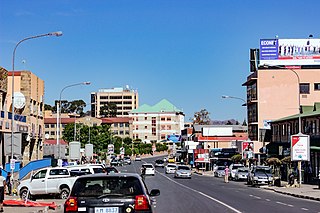
Maseru is the capital and largest city of Lesotho. It is also the capital of the Maseru District. Located on the Caledon River, Maseru lies directly on the Lesotho–South Africa border. Maseru had a population of 330,760 in the 2016 census. The city was established as a police camp and assigned as the capital after the country became a British protectorate in 1869. When the country achieved independence in 1966, Maseru retained its status as capital. The name of the city is a Sesotho word meaning "red sandstones".

South Africa occupies the southern tip of Africa, its coastline stretching more than 2,850 kilometres from the desert border with Namibia on the Atlantic (western) coast southwards around the tip of Africa and then northeast to the border with Mozambique on the Indian (eastern) coast. The low-lying coastal zone is narrow for much of that distance, soon giving way to a mountainous escarpment that separates the coast from the high inland plateau. In some places, notably the province of KwaZulu-Natal in the east, a greater distance separates the coast from the escarpment. Although much of the country is classified as semi-arid, it has considerable variation in climate as well as topography. The total land area is 1,220,813 km2 (471,359 sq mi). It has the 23rd largest Exclusive Economic Zone of 1,535,538 km2 (592,875 sq mi).
SothoSesotho, also known as Southern Sotho or Sesotho sa Borwa is a Southern Bantu language of the Sotho–Tswana ("S.30") group, spoken in Lesotho, and South Africa where it is an official language.

The Sotho, also known as the Basotho, are a Sotho-Tswana ethnic group native to Southern Africa. They primarily inhabit the regions of Lesotho and South Africa.

The National University of Lesotho, the main and oldest university in Lesotho, is located in Roma, 34 km (21 mi) southeast of Maseru, the capital of Lesotho. The Roma valley is broad and is surrounded by a barrier of rugged mountains which provides magnificent scenery. The university enjoys a temperate climate with four distinct seasons. The governing body of the university is the council and academic policy is in the hands of Senate, both Council and Senate being established by the Act.

Mokhotlong is a constituency, city and seat of Mokhotlong District in the mountainous northeastern part of Lesotho. It is the first major city with an airport along the road from South Africa across the Sani Pass, near the Maloti Mountains. The name of the city is a word in Sesotho, the language of the people of Lesotho, meaning "Place of the Bald Ibis." Thabana Ntlenyana, the highest point in southern Africa, is found in Mokhotlong.

The Highveld is the portion of the South African inland plateau which has an altitude above roughly 1,500 m (4,900 ft), but below 2,100 m (6,900 ft), thus excluding the Lesotho mountain regions to the south-east of the Highveld. It is home to some of the country's most important commercial farming areas, as well as its largest concentration of metropolitan centres, especially the Gauteng conurbation, which accommodates one-third of South Africa's population.

Teyateyaneng is a town located in the district of Berea in Lesotho. Usually abbreviated to T.Y., Teyateyaneng takes its name from the two twin rivers which run on the north and the South. Both rivers lead to the Mohokare, or the Caledon River which forms the western boundary with South Africa. They are both named for their vast quantities of sand which means rapid dipping of feet as one crosses them, leading to both names which may well suggest that this is a 'place of quick sands'. Teyateyaneng's name therefore comes from the southern Teja-tejana River, but the name later changed to Teyateyaneng, perhaps due to British influences as the country became a Protectorate in the late 1800s.

The Great Escarpment is a major topographical feature in Africa that consists of steep slopes from the high central Southern African plateau downward in the direction of the oceans that surround southern Africa on three sides. While it lies predominantly within the borders of South Africa, in the east the escarpment extends northward to form the border between Mozambique and Zimbabwe, continuing on beyond the Zambezi river valley to form the Muchinga Escarpment in eastern Zambia. In the west, it extends northward into Namibia and Angola. It is the combination of this escarpment and the aridity of Southern Africa that leads to the lack of navigable rivers in South Africa.
Marakabei is a town in central Lesotho. It is located southeast of the capital Maseru, close to the banks of the Senqunyane River, between the God Help Me Pass and Mokhoabong Pass.
The God Help Me Pass, or Lekhalong-la-Molimo-Nthuse in seSotho, is a mountain pass at an elevation of 2,318 m (7,605 ft) in western Lesotho. It is the second mountain pass on the A3 road going into the central highlands. The road ascends steeply from the village of Setibing, and near the summit is the Basotho Pony Trekking Centre, which offers a variety of trekking expeditions. The Makhaleng River flows close by Setibing, and its valley forms the western approach to the pass. The higher Blue Mountain Pass, 2,641 m (8,665 ft), Lekhalong-la-Thaba-Putsoa, is a few kilometres further east, and the first mountain pass, Bushman's Pass, Lekhalong-la-Baroa, 2,266 m (7,434 ft) is about 10 kilometres (6 mi) to the west, rising from the town of Nazareth.
Morija is a town in western Lesotho, located 35 kilometres south of the capital, Maseru. Morija is one of Lesotho's most important historical and cultural sites, known as the Selibeng sa Thuto— the Well-Spring of Learning. It was the site of the first French Protestant mission in Lesotho, founded in 1833. The town also houses the Morija Museum and Archives, well known for supporting research and preserving valuable records and documents of Lesotho's history.
Matebeng is a town in southeast Lesotho, situated close to the Senqu River. It lies at the western approach to the Matebeng Pass, which links it with the town of Mavuka.
Sandlane is the westernmost town in Eswatini. It is located close to the border with South Africa, 40 kilometres southwest of the capital, Mbabane.
Sicunusa is a town in southwest Eswatini. It is located close to the border with South Africa.
Lubuli is a town in southeastern Eswatini (Swaziland). It is located close to the South African border just to the northwest of the town of Nsoko on the road between there and Maloma.

The Elliot Formation is a geological formation and forms part of the Stormberg Group, the uppermost geological group that comprises the greater Karoo Supergroup. Outcrops of the Elliot Formation have been found in the northern Eastern Cape, southern Free State, and in the eastern KwaZulu-Natal provinces of South Africa. Outcrops and exposures are also found in several localities in Lesotho such as Qacha's Neck, Hill Top, Quthing, and near the capital, Maseru. The Elliot Formation is further divided into the lower (LEF) and upper (UEF) Elliot formations to differentiate significant sedimentological differences between these layers. The LEF is dominantly Late Triassic (Norian-Hettangian) in age while the UEF is mainly Early Jurassic (Sinemurian-Pliensbachian) and is tentatively regarded to preserve a continental record of the Triassic-Jurassic boundary in southern Africa. This geological formation is named after the town of Elliot in the Eastern Cape, and its stratotype locality is located on the Barkly Pass, 9 km north of the town.

The Lesotho Highlands are formed by the Drakensberg and Maloti mountain ranges in the east and central parts of the country of Lesotho. Foothills form a divide between the lowlands and the highlands. Snow is common in the highlands in the winter.
References
- Fitzpatrick, M., Blond, B., Pitcher, G., Richmond, S., and Warren, M. (2004) South Africa, Lesotho and Swaziland. Footscray, VIC: Lonely Planet.
29°53′58″S29°03′20″E / 29.8994°S 29.0555°E
| | This Lesotho location article is a stub. You can help Wikipedia by expanding it. |