
Butte is a village in Boyd County, Nebraska, United States. The population was 326 at the 2010 census, down from 366 at the 2000 census. It is the county seat of Boyd County.

Fort Washakie is a census-designated place (CDP) in Fremont County, Wyoming, United States, within the Wind River Indian Reservation and along U.S. Route 287. The population was 1,759 at the 2010 census. The headquarters for the Eastern Shoshone Tribe is located in Fort Washakie, as well as the Bureau of Indian Affairs agency for the Wind River Indian Reservation.

The Borough of Harrogate is a local government district and borough of North Yorkshire, England. Its population at the census of 2011 was 157,869. Its council is based in the town of Harrogate, but it also includes surrounding towns and villages and almost all of the Nidderdale Area of Outstanding Natural Beauty. It is the most populous district of North Yorkshire. The district is part of the Leeds City Region. It borders the City of Leeds, and the City of Bradford, districts of West Yorkshire.

Sonatikiri is a census town in Gaighata CD Block of Bangaon subdivision in North 24 Parganas district in the Indian state of West Bengal.
Amdanga is a community development block that forms an administrative division in Barasat Sadar subdivision of North 24 Parganas district in the Indian state of West Bengal.
Olsza is a village in the administrative district of Gmina Milicz, within Milicz County, Lower Silesian Voivodeship, in south-western Poland. Prior to 1945 it was in Germany.

Mababe is a village in North-West District of Botswana. It is located in the eastern part of the district, and has a primary school. The population was 157 in 2001 census.
Makalamabedi is a village in North-West District of Botswana. It is located in the south-east part of the district, and is served by the local Makalamabedi Airport. The population was 344 in 2001 census.
Oodi or Odi is a village in Kgatleng District of Botswana. It is located 20 km north-east of Gaborone. The population was 3,440 in 2001 census.
Kaudwane is a village in Kweneng District of Botswana. The village is located in Kalahari Desert, around 220 km north-west of Gaborone, and it has a primary school. The population was 551 in 2001 census.
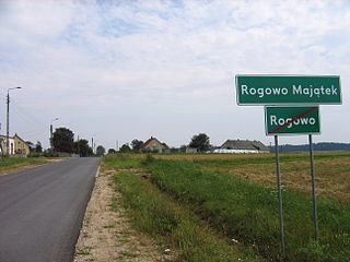
Rogowo-Majątek is a village in the administrative district of Gmina Choroszcz, within Białystok County, Podlaskie Voivodeship, in north-eastern Poland. It lies approximately 5 kilometres (3 mi) west of Choroszcz and 18 km (11 mi) west of the regional capital Białystok.

Dąbrowa is a village in the administrative district of Gmina Wieluń, within Wieluń County, Łódź Voivodeship, in central Poland. It lies approximately 3 kilometres (2 mi) north-west of Wieluń and 89 km (55 mi) south-west of the regional capital Łódź.
Stary Kromolin is a village in the administrative district of Gmina Szadek, within Zduńska Wola County, Łódź Voivodeship, in central Poland. It lies approximately 6 kilometres (4 mi) south-west of Szadek, 9 km (6 mi) north-west of Zduńska Wola, and 41 km (25 mi) west of the regional capital Łódź.
Dąbrowno is a village in the administrative district of Gmina Niegowa, within Myszków County, Silesian Voivodeship, in southern Poland. It lies approximately 5 kilometres (3 mi) north-east of Niegowa, 19 km (12 mi) north-east of Myszków, and 61 km (38 mi) north-east of the regional capital Katowice.
Lipniki is a village in the administrative district of Gmina Kamiennik, within Nysa County, Opole Voivodeship, in south-western Poland. It lies approximately 6 kilometres (4 mi) south-west of Kamiennik, 19 km (12 mi) north-west of Nysa, and 62 km (39 mi) west of the regional capital Opole.
Świtały is a village in the administrative district of Gmina Damnica, within Słupsk County, Pomeranian Voivodeship, in northern Poland. It lies approximately 8 kilometres (5 mi) north-east of Damnica, 24 km (15 mi) east of Słupsk, and 85 km (53 mi) west of the regional capital Gdańsk.
Swarupnagar is a community development block that forms an administrative division in Basirhat subdivision of North 24 Parganas district in the Indian state of West Bengal.
Haroa is a community development block that forms an administrative division in Basirhat subdivision of North 24 Parganas district in the Indian state of West Bengal.
Barasat II is a community development block that forms an administrative division in Barasat Sadar subdivision of North 24 Parganas district in the Indian state of West Bengal.
Bangaon is a community development block that forms an administrative division in Bangaon subdivision of North 24 Parganas district in the Indian state of West Bengal.


