Related Research Articles

Eswatini, officially the Kingdom of Eswatini and also known by its former official name Swaziland, is a landlocked country in Southern Africa. It is bordered by Mozambique to its northeast and South Africa to its north, west, south, and southeast. At no more than 200 km (120 mi) north to south and 130 km (81 mi) east to west, Eswatini is one of the smallest countries in Africa; despite this, its climate and topography are diverse, ranging from a cool and mountainous highveld to a hot and dry lowveld.

Mbabane is a city in Eswatini, and is one of the two capitals, serving as the executive capital.

Hhohho is a region of Eswatini, located in the north western part of the country. Hhohho was named after the capital of King Mswati II, who expanded the Swazi territory to the north and west, taking in the districts of Barberton, Nelspruit, Carolina and Piet Retief. These areas were later acquired by what was the Province of Transvaal and today they form part of the Mpumalanga Province of South Africa. It has an area of 3,625.17 km², a population of 320,651 (2017), and is divided into 14 tinkhundla. The administrative center is the national capital of Mbabane. It borders Lubombo Region on the southeast and Manzini Region in the southwest.

Manzini is a region of Eswatini, located in the center-west of the country. It has an area of 4,093.59 km² and a population of 355,945 (2017). Its administrative center is Manzini. It borders all three other regions of Eswatini: Hhohho in the north, Lubombo in the east, and Shiselweni in the south. It is bordered by the Mpumalanga province in South Africa to the west.

Royal Swazi National Airways Corporation was the national airline of the Kingdom of Swaziland. Headquartered in Mbabane with its operational base at Matsapha Airport near Manzini, the airline was founded in 1978. The company still exists, since 2018 under the name Royal Eswatini National Airways Corporation (RENAC), although it does not own an airline, but provides services in the airline sector.

Lobamba is a city in Eswatini, and is one of the two capitals, serving as the legislative, traditional, spiritual, seat of government of the Parliament of Eswatini, and Ludzidzini Royal Village, the residence of Queen Ntfombi, the Queen Mother.

Manzini is a large city in Eswatini (Swaziland), which is also the capital of Eswatini's Manzini Region. The city is the country's second largest urban center behind the capital Mbabane, with a population of 110,000 (2008). It is known as "The Hub" of Eswatini and lies on the MR3 road. Eswatini's primary industrial site at Matsapha lies near the town's western border.

Matsapha Airport is an airport located near Manzini, a city in Manzini District in the center-west of Eswatini. It serves flights of the Eswatini Government and mercy flights.
Siphofaneni is a town in the Lubombo Region of central Eswatini (Swaziland), 45 kilometres from Manzini and 20 kilometres from Big Bend, a major sugarcane-producing town on the main highway leading to Durban. It has a tropical climate, very hot during summer and cold in winter. Malaria is endemic in Lubombo. Siphofaneni has hot springs and is surrounded by several sugarcane farms. It is located on the banks of the largest river in Swaziland, the Usutu.
Eswatini Railways (ESR), formerly known as Swaziland Railway or Swazi Rail, is the national railway corporation of Eswatini.
The following outline is provided as an overview of and topical guide to Eswatini:
Prostitution in Eswatini is illegal, the anti-prostitution laws dating back to 1889, when the country Eswatini was a protectorate of South Africa. Law enforcement is inconsistent, particularly near industrial sites and military bases. Police tend to turn a blind eye to prostitution in clubs. There are periodic clamp-downs by the police.
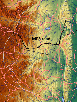
The MR3 road, also known as the Matsapha–Mbabane–Ngwenya road or Road No. MR3, is a major highway of Eswatini. It is one of the busiest roads in the country, crossing it from east to west. Along with the MR7 and MR8 roads, it forms the "backbone of Swaziland's internal transport system." It connects the EN5 road in Mozambique near Namaacha at 25°59′21″S31°59′53″E to the N17 road in South Africa at 26°12′45″S30°59′18″E, near Ngwenya. The road passes through Hlane Royal National Park and through the capital of Mbabane, about 110 kilometres (68 mi) further to the southwest. The highway descends into the Ezulwini Valley in four lanes. At Manzini, a bridge crosses the Mzimene River.

Lubombo is a region of Eswatini, located in the east of the country. It has an area of 5,849.11 km² and a population of 212,531 (2017). Its administrative center is Siteki. It borders all three other regions: Hhohho to the north, Manzini to the west, and Shiselweni to the south. It is divided into 11 tinkhundla.
Bhunya Airfield is a rural airstrip serving Bhunya, a forest products community in the Manzini Region of Eswatini. It is 8 kilometres (5 mi) southwest of the town.
Eswatini Bank, also known as Eswatini Development & Savings Bank (EDSP), is a development finance institution, which doubles as a commercial bank in Eswatini. It is licensed and supervised by the Central Bank of Eswatini, the national banking regulator. As of April 2019 Eswatini Bank was the only indigenous commercial bank in the country, with the other three having their headquarters in neighboring South Africa.

Goba railway, also called Swaziland-Maputo railway and Matsapha-Maputo railway, is a railway that connects the city of Maputo, Mozambique, to the city from Matsapha, in Eswatini. It is 466.8 km long, in a 1067 mm gauge.
Eswatini remained a British protectorate throughout World War II. As such, it fought alongside the Allies against the Axis. While no large scale battles or major military operations took place in or around Eswatini, the colony did supply the Allies with troops during the war. World War II was also responsible for several important domestic developments in Eswatini.
Edwaleni Solar Power Station, is a 100 megawatts solar power plant under construction in Eswatini. The solar farm is under development by Frazium Energy, a subsidiary of the Frazer Solar Group, an Australian-German conglomerate. The solar component is complemented by a battery energy storage system, expected to be the largest in Africa. The energy off-taker is Eswatini Electricity Company (EEC), the national electricity utility parastatal company, under a 40-year power purchase agreement (PPA). EEC plans to inject the energy into the Southern Africa Power Pool, for use primarily in South Africa.
References
- ↑ "MATSAPHA INTERNATIONAL AIRPORT". Swacca. Retrieved 1 December 2013.