Related Research Articles
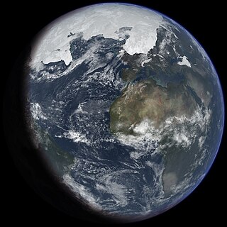
An ice age is a long period of reduction in the temperature of Earth's surface and atmosphere, resulting in the presence or expansion of continental and polar ice sheets and alpine glaciers. Earth's climate alternates between ice ages, and greenhouse periods during which there are no glaciers on the planet. Earth is currently in the ice age called Quaternary glaciation. Individual pulses of cold climate within an ice age are termed glacial periods, and intermittent warm periods within an ice age are called interglacials or interstadials.

The Pleistocene is the geological epoch that lasted from c. 2.58 million to 11,700 years ago, spanning the Earth's most recent period of repeated glaciations. Before a change was finally confirmed in 2009 by the International Union of Geological Sciences, the cutoff of the Pleistocene and the preceding Pliocene was regarded as being 1.806 million years Before Present (BP). Publications from earlier years may use either definition of the period. The end of the Pleistocene corresponds with the end of the last glacial period and also with the end of the Paleolithic age used in archaeology. The name is a combination of Ancient Greek πλεῖστος (pleîstos) 'most' and καινός 'new'.
The Toba eruption was a supervolcanic eruption that occurred about 74,000 years ago during the Late Pleistocene at the site of present-day Lake Toba in Sumatra, Indonesia. It was the last in a series of at least four caldera-forming eruptions at this location, with the earlier known caldera having formed around 1.2 million years ago. This last eruption had an estimated VEI of 8, making it the largest-known explosive volcanic eruption in the Quaternary, and one of the largest known explosive eruptions in the Earth's history.

Beringia is defined today as the land and maritime area bounded on the west by the Lena River in Russia; on the east by the Mackenzie River in Canada; on the north by 72° north latitude in the Chukchi Sea; and on the south by the tip of the Kamchatka Peninsula. It includes the Chukchi Sea, the Bering Sea, the Bering Strait, the Chukchi and Kamchatka Peninsulas in Russia as well as Alaska in the United States and the Yukon in Canada.

There have been five or six major ice ages in the history of Earth over the past 3 billion years. The Late Cenozoic Ice Age began 34 million years ago, its latest phase being the Quaternary glaciation, in progress since 2.58 million years ago.

The Anglian Stage is the name used in the British Isles for a middle Pleistocene glaciation. It precedes the Hoxnian Stage and follows the Cromerian Stage in the British Isles. It correlates to Marine Isotope Stage 12, which started about 478,000 years ago and ended about 424,000 years ago.
The Hoxnian Stage was a middle Pleistocene stage of the geological history of the British Isles. It was an interglacial which preceded the Wolstonian Stage and followed the Anglian Stage. It is equivalent to Marine Isotope Stage 11. Marine Isotope Stage 11 started 424,000 years ago and ended 374,000 years ago. The Hoxnian is divided into sub-stages Ho I to Ho IV. It is likely equivalent to the Holstein Interglacial in Central Europe.
Diamicton is a terrigenous sediment that is unsorted to poorly sorted and contains particles ranging in size from clay to boulders, suspended in an unconsolidated matrix of mud or sand. Today, the word has strong connotations to glaciation but can be used in a variety of geological settings.

The Quaternary glaciation, also known as the Pleistocene glaciation, is an alternating series of glacial and interglacial periods during the Quaternary period that began 2.58 Ma and is ongoing. Although geologists describe this entire period up to the present as an "ice age", in popular culture this term usually refers to the most recent glacial period, or to the Pleistocene epoch in general. Since Earth still has polar ice sheets, geologists consider the Quaternary glaciation to be ongoing, though currently in an interglacial period.

The Cromer Forest-bed Formation, sometimes known as the Cromer Forest Bed, is a geological formation in Norfolk, England. It consists of river gravels, estuary and floodplain sediments predominantly silt, sand, and muds as well as peat along the coast of northern Norfolk. It is the type locality for the Cromerian Stage of the Pleistocene between 0.8 and 0.5 million years ago. The deposit itself range varies in age from about 0.8 to 0.5 million years ago. It is about 6-to-8-metre thick and is exposed in cliff section near the town of West Runton.

Dropstones are isolated fragments of rock found within finer-grained water-deposited sedimentary rocks or pyroclastic beds. They range in size from small pebbles to boulders. The critical distinguishing feature is that there is evidence that they were not transported by normal water currents, but rather dropped in vertically through the air or water column. Such depositions can occur during a volcanic eruption, e.g.
Andrew Shaw Goudie is a geographer at the University of Oxford specialising in desert geomorphology, dust storms, weathering, and climatic change in the tropics. He is also known for his teaching and best-selling textbooks on human impacts on the environment. He is the author, co-author, editor, or co-editor of forty-one books and more than two hundred papers published in learned journals. He combines research and some teaching with administrative roles.
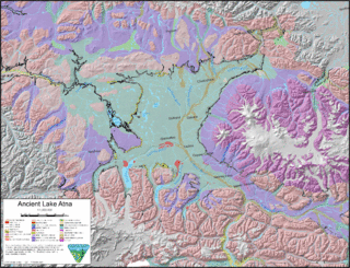
Lake Atna was a prehistoric proglacial lake that initially formed approximately 58 ka in the Copper River Basin, an area roughly centered around 245 km (152 mi) northeast of modern-day Anchorage, Alaska. The lake formed, and dispersed, during the Wisconsin glaciation. The lake existed in several forms, with several prominent shorelines observable in modern geology. At its greatest extent, the lake surface area was approximately half the size of modern-day Lake Ontario, and possibly much larger. The basin of the lake lay within an area bordered by the Alaska Range to the north, the Wrangell Mountains to the east, the Chugach Mountains to the south, and the Talkeetna Mountains to the west.

The Sabana Formation is a geological formation of the Bogotá savanna, Altiplano Cundiboyacense, Eastern Ranges of the Colombian Andes. The formation consists mainly of shales with at the edges of the Bogotá savanna lignites and sandstones. The Sabana Formation dates to the Quaternary period; Middle to Late Pleistocene epoch, and has a maximum thickness of 320 metres (1,050 ft), varying greatly across the savanna. It is the uppermost formation of the lacustrine and fluvio-glacial sediments of paleolake Humboldt, that existed at the edge of the Eastern Hills until the latest Pleistocene.

Herbert Edgar Wright Jr. was an American Quaternary scientist. He contributed to the understanding of landscape history and environmental changes over the past 100,000 years in many parts of the world. He studied arid-region geomorphology and landscape evolution, as well as glacial geology and climate history. His study of these topics led him to the study of vegetation development and environmental history and allowed him to define the timing and mechanisms of climate-driven vegetational shifts in North America during the last 18,000 years and to recognize the role of natural fire in the dynamics of northern coniferous forests. He applied these insights to wilderness conservation and landscape management. He covered many other aspects of paleoecology including lake development and paleolimnology, and the history and development of the vast patterned peatlands of Minnesota and elsewhere in the Northern Hemisphere. Although his work was concentrated in Minnesota, he was also involved in a major synthesis of global paleoclimatology. Beyond Minnesota and the Great Lakes region, Wright studied a wide range of research questions elsewhere in North America, and in the Near East, Europe, Asia, Latin America, and Antarctica. He advised over 75 graduate students and mentored many more students, visitors, and colleagues worldwide.
Robin Huw Crompton is professor of musculoskeletal biology at the University of Liverpool in the Institute of Ageing and Chronic Disease. He has developed the Fossil Footprint Archive jointly with Matthew Bennett of Bournemouth University. He has criticized the March of Progress image for implying that the common ancestor taxon of all great apes wouldn't have been bipedal, when fossil evidence suggests it would have been.

Lake Circle was a glacial lake that formed during the late Pleistocene epoch along the Redwater River in eastern Montana. After the Laurentide Ice Sheet retreated, glacial ice melt accumulated in the basin surrounded by the ridges of the preglacial valley and the retreating glacier. Southwest of Nickwall are the remnants of a broad abandoned valley with long side slopes. The valley runs north from Redwater Creek to the Missouri River. The bottom is poorly drained and about 1 mile (1.6 km) in width. It lies 2,015 to 2,020 feet above the sea level and 40 to 50 feet above the Missouri River bottomland. The upland slopes are extensive, clear and flat. The valleys surrounding it are dissected with V-shaped coulees. The difference between the Redwater valley and those around it reflect stream erosion vs. lake sedimentation. The drift in the valleys, appears to be as left by the glacier in the previously created valleys. Using the dating of lake deposits near Great Falls, Montana, the Havre lobe of the Laurentide Ice Sheet dammed the ancestral Missouri River during the late Wisconsin Glacial Period.
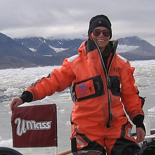
Julie Brigham-Grette is a glacial geologist and a professor in the Department of Geosciences at the University of Massachusetts Amherst where she co-directs the Joseph Hartshorn Quaternary Laboratory. Her research expertise is in glacial geology and paleoclimatology; she has made important contributions to Arctic marine and terrestrial paleoclimate records of the late Cenozoic to recent periods, the evolution of the Arctic climate, especially in the Beringia/Bering Strait region, and was a leader of the international Lake El’gygytgyn Drilling Project in northeastern Russia.

A geological event is a temporary and spatially heterogeneous and dynamic (diachronous) happening in Earth history that contributes to the transformation of Earth system and the formation of geological strata. Event stratigraphy was first proposed as a system for the recognition, study and correlation of the effects of important physical or biological events on the broader stratigraphical record.

The White Sands fossil footprints are a set of fossilized human footprints discovered in 2009 in the White Sands National Park in New Mexico. In 2021 they were radiocarbon dated, based on seeds found in the sediment layers, to between 21,000 and 23,000 years ago. If that date range is correct, they would be one of, if not the oldest record of humans in the Americas. The 61 footprints are located at the shore of an ice age era lake in the Tularosa Basin. The tracks are associated with those of extinct megafauna, such as Columbian mammoths and ground sloths.
References
- ↑ "Professor Matthew Bennett - Bournemouth University Staff Profile Pages". staffprofiles.bournemouth.ac.uk. Retrieved 2017-09-06.
- ↑ Reuters Editorial. "Footprints show human ancestor with modern stride". Reuters. Retrieved 2017-09-06.
{{cite web}}:|author=has generic name (help)[ dead link ] - ↑ "BBC NEWS | Science & Environment | Earliest 'human footprints' found". news.bbc.co.uk. Retrieved 2017-09-06.
- ↑ "Footprint Data Archive". footprints.bournemouth.ac.uk. Retrieved 2017-09-06.