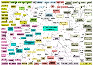
Information and communications technology (ICT) is an extensional term for information technology (IT) that stresses the role of unified communications and the integration of telecommunications and computers, as well as necessary enterprise software, middleware, storage and audiovisual, that enable users to access, store, transmit, understand and manipulate information.
ICBMaddress or missile address is hacker slang for one's longitude and latitude when placed in a signature or another publicly available file.
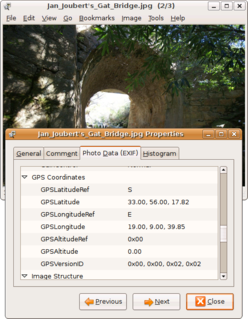
Geotagging, or GeoTagging, is the process of adding geographical identification metadata to various media such as a geotagged photograph or video, websites, SMS messages, QR Codes or RSS feeds and is a form of geospatial metadata. This data usually consists of latitude and longitude coordinates, though they can also include altitude, bearing, distance, accuracy data, and place names, and perhaps a time stamp.
A GIS software program is a computer program to support the use of a geographic information system, providing the ability to create, store, manage, query, analyze, and visualize geographic data, that is, data representing phenomena for which location is important. The GIS software industry encompasses a broad range of commercial and open-source products that provide some or all of these capabilities within various information technology architectures.
John Alan Glennon is an American geographer and explorer. His work has been mapping and describing caves and geysers.
Geovisualization or geovisualisation, also known as cartographic visualization, refers to a set of tools and techniques supporting the analysis of geospatial data through the use of interactive visualization.
The concept of a Geospatial Web may have first been introduced by Dr. Charles Herring in his US DoD paper, An Architecture of Cyberspace: Spatialization of the Internet, 1994, U.S. Army Construction Engineering Research Laboratory.
Digital Earth is the name given to a concept by former US vice president Al Gore in 1998, describing a virtual representation of the Earth that is georeferenced and connected to the world's digital knowledge archives.
Geobytes is a global company specializing in geolocation and anti-spam software. Geobytes was incorporated in the State of Delaware, USA in 1999 making it one of the oldest companies in the online geolocation industry.
Collaborative mapping is the aggregation of Web mapping and user-generated content, from a group of individuals or entities, and can take several distinct forms. With the growth of technology for storing and sharing maps, collaborative maps have become competitors to commercial services, in the case of OpenStreetMap, or components of them, as in Google Map Maker and Yandex.Map editor.
Critical cartography is a set of mapping practices and methods of analysis grounded in critical theory, specifically the thesis that maps reflect and perpetuate relations of power, typically in favor of a society's dominant group. Critical cartographers aim to reveal the “‘hidden agendas of cartography’ as tools of socio-spatial power”. While the term "critical cartography" often refers to a body of theoretical literature, critical cartographers also call for practical applications of critical cartographic theory, such as counter-mapping, participatory mapping, and neogeography.
MetaCarta is a software company that developed one of the first search engines to use a map to find unstructured documents. The product uses natural language processing to georeference text for customers in defense, intelligence, homeland security, law enforcement, oil and gas companies, and publishing. The company was founded in 1999 and was acquired by Nokia in 2010. Nokia subsequently spun out the enterprise products division and the MetaCarta brand to Qbase, now renamed to Finch.

Broadband mapping in the United States are efforts to describe geographically how Internet access service from telephone and cable TV companies is available in terms of available speed and price. Mapping has been done on the national as well as the state level. The efforts are seen as preliminary steps towards broadband universal service.
Neogeography is the use of geographical techniques and tools for personal and community activities or by a non-expert group of users. Application domains of neogeography are typically not formal or analytical.
Price of Weed is a user-generated database of marijuana prices. Users may submit prices and quantities for transactions and their location is geolocated in order to generate a price index for states and cities. While user-generated prices have no inherent check on accuracy, the criminal status of marijuana in many countries means a formal price index may be difficult to construct.

WorldMap is a web platform for creating, displaying, analyzing, and searching spatial data and other data forms across multiple disciplines.

The Department of Geography in the College of Arts & Sciences at the University of Kentucky offers undergraduate degrees and graduate degrees and courses in physical and human geography. The department has an international reputation for the study of social theory and critical geography, including political ecology. Located in Lexington, Kentucky, the department is consistently ranked among leading geography graduate programs in the United States. The graduate students have organized the annual international conference, Dimensions of Political Ecology or DOPE, since 2010. In the summer of 2012, the department and faculty offices moved to the eighth floor of Patterson Office Tower.
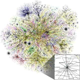
Internet geography, also called cybergeography, is a subdiscipline of geography that studies the spatial organization of the Internet, from social, economic, cultural, and technological perspectives. The core assumption of Internet geography is that the location of servers, websites, data, services, and infrastructure is key to understand the development and the dynamics of the Internet. Among the topics covered by this discipline, of particular importance are information geography and digital divides.
Lawrence Martin was an American geographer and President of the American Association of Geographers.

The geographical bias on Wikipedia is an inequality in the distribution of its content with respect to the geographical association of article subjects. It is an element of criticism of Wikipedia, in addition to other biases, such as gender bias, racial bias, or ideological. The research shows that despite considerable differences of this distribution depending on the language of Wikipedia, there is a common trend towards more content related to the United States and Western Europe coupled with the scarcity of information about certain regions in the rest of the world.
