Hitra is a municipality in Trøndelag county, Norway. The municipality covers the island of Hitra and hundreds smaller islands, islets, and skerries. It is part of the Fosen region. The administrative centre of the municipality is the village of Fillan. Other villages include Andersskogan, Ansnes, Forsnes, Hestvika, Knarrlagsund, Kvenvær, Melandsjøen, Nordbotn, Sandstad, and Ulvan.
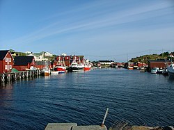
Sistranda is the administrative centre of the municipality of Frøya in Trøndelag county, Norway. The village is located on the east side of the island of Frøya, about 4 kilometres (2.5 mi) north of the village of Hammarvika and the entrance to the Frøya Tunnel. The 1.04-square-kilometre (260-acre) village has a population (2018) of 1,041 and a population density of 1,001 inhabitants per square kilometre (2,590/sq mi).
Sør-Frøya is a former municipality in the old Sør-Trøndelag county, Norway. The 102-square-kilometre (39 sq mi) municipality existed from 1906 until its dissolution in 1964. Sør-Frøya included the southwestern part of the island of Frøya in what is now the municipality of Frøya in Trøndelag county. The main population center of Sør-Frøya was the village of Titran on the western tip of the island. The main church for the municipality was Hallaren Church which is located in Storhallaren on the southern coast of the island.
Nord-Frøya is a former municipality in the old Sør-Trøndelag county, Norway. The 139-square-kilometre (54 sq mi) municipality existed from 1906 until its dissolution in 1964. Nord-Frøya included the northern part of the island of Frøya and all of the small islands to the north and northeast such as Sula, Mausund, Froan, and Halten in what is now the municipality of Frøya in Trøndelag county. The main church for the municipality was Sletta Church which is located at Svellingen on the northern coast of the island.

Titran is a village in the municipality of Frøya in Trøndelag county, Norway. It is located at the western end of the island of Frøya, about 30 kilometres (19 mi) west of the villages of Hammarvika and Sistranda. The Sletringen Lighthouse is located on a small islet off the coast of Titran. The village is centered on fishing and fish farming and in 2017, there were 105 residents. Titran Chapel is located in the village.
Froan or Froøyene is a populated archipelago of small, rocky islands in the municipality of Frøya in Trøndelag county, Norway. Froan consists of several hundred islands and islets that lie in the sea about 30 kilometres (19 mi) west of the Fosen peninsula. The islands run for about 40 kilometres (25 mi) in a northeasterly direction, parallel to the coastline. The island village of Halten lies at the northern end of the island chain. Only a few of the islands are inhabited, and in 2017, the population was only 38. The Froan Chapel, built in 1904, is located on the island of Sauøya. The Halten Lighthouse and others are located throughout the islands.

Halten is an unpopulated fishing village in the municipality of Frøya in Trøndelag county, Norway. The village was located on several adjacent islands at the far northern end of the Froan island chain. They constituted the northernmost part of the string of islands north of Frøya, which stretch from Sula in the south to Halten in the north. Halten Lighthouse is located on the island of Halten in the central part of the fishing village. The fishing village primarily was located on the islands of Husøya, Halten, Steinsøya, and Rorsøya. A large breakwater was built to protect the harbour area of the village. The village has had no permanent residents since 1988, but during the summers there are many vacationers and tourists.

Halten Lighthouse is a coastal lighthouse in the municipality of Frøya in Trøndelag county, Norway. The lighthouse is situated in the now uninhabited fishing village of Halten. It was first lit in 1875, and it is the northernmost of the chain of lighthouses marking the string of islands called Froan north of Frøya. The lighthouses include Sula Lighthouse in south, Vingleia Lighthouse, Finnvær Lighthouse, and finally Halten Lighthouse. The lighthouse emits the morse code letter "T" (—) as a racon signal.
Bremnestuva or Bremnestua is a small mountain in the municipality of Frøya in Trøndelag county, Norway. The 74-metre (243 ft) tall mountain lies on the northwest side of the island of Frøya. There is a road to the top of the mountain where there is a water tank, a mobile telephone tower, and a great view.

Sula is an island group in the municipality of Frøya in Trøndelag county, Norway. It is located about 10 kilometres (6.2 mi) west of the island village of Mausund and about 15 kilometres (9.3 mi) northwest of the island of Frøya.
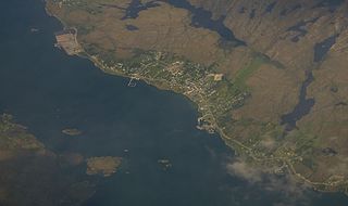
Hammarvika is a village in the municipality of Frøya in Trøndelag county, Norway. The village is located about 4 kilometres (2.5 mi) south of the municipal center of Sistranda on the southeastern side of the island of Frøya. The 0.58-square-kilometre (140-acre) village has a population (2018) of 461 and a population density of 795 inhabitants per square kilometre (2,060/sq mi).

Vingleia Lighthouse is a coastal lighthouse in the municipality of Frøya in Trøndelag county, Norway. The lighthouse sits on the island of Skarvfleshølen about 6 kilometres (3.7 mi) north of the island village of Mausund, about 13 kilometres (8.1 mi) northeast of the Sula Lighthouse, about 26 kilometres (16 mi) southwest of the Finnvær Lighthouse, and about 45 kilometres (28 mi) southwest of the Halten Lighthouse. It is lit from 21 July until 16 May each year. It is not lit during the summer due to the midnight sun of the region.
Sula Chapel is a parish church in Frøya municipality in Trøndelag county, Norway. It is located on the island of Sula. It is one of the churches for the Frøya parish which is part of the Orkdal prosti (deanery) in the Diocese of Nidaros. The white, wooden church was built in a long church style in 1925 by the architect Martin Pettersen. The church seats about 200 people.

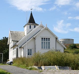
Sletta Church is a parish church in Frøya municipality in Trøndelag county, Norway. It is located to the northeastern shore of the island of Frøya, about 8 kilometres (5.0 mi) north of the municipal center of Sistranda. It is one of the churches for the Frøya parish which is part of the Orkdal prosti (deanery) in the Diocese of Nidaros. The white, circular, concrete church was built in a modern style in 1990 by the architect Odd Østbye. The church seats about 430 people.

Titran Chapel (Norwegian: Titran kapell is a parish church in Frøya municipality in Trøndelag county, Norway. It is located in the village of Titran on the western tip of the island of Frøya. It is one of the churches for the Frøya parish which is part of the Orkdal prosti in the Diocese of Nidaros. The white, wooden church was built in a octagonal style in 1873 as a bedehus and it was upgraded to the status of a chapel in 1912. The church seats about 200 people. The chapel was built on the site of an old church that closed and torn down in 1780.
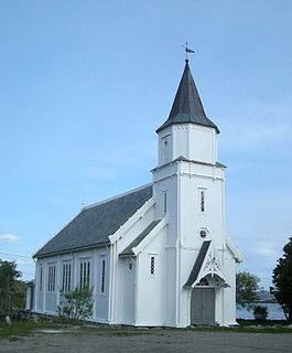
Hallaren Church is a parish church in Frøya municipality in Trøndelag county, Norway. It is located in the village of Storhallaren on the southern coast of the island of Frøya. It is one of the churches for the Frøya parish which is part of the Orkdal prosti (deanery) in the Diocese of Nidaros. The white, wooden church was built in a long church style in 1881 by the architect Henrik Nissen. The church seats about 400 people. This was the main church for the old municipality of Sør-Frøya which existed prior to 1964.
Dolmøya is an island in the municipality of Hitra in Trøndelag county, Norway. The island is located in the Frøyfjorden, just north of the village of Melandsjøen on the island of Hitra. The island of Dolmøya is flat, swampy, and has very few trees. The 14.5-square-kilometre (5.6 sq mi) island is also the location of the southern entrance to the Frøya Tunnel. The medieval Dolm church is located on the southeastern shore of the island. There were about 488 residents living on the island in 2017.

Besselvassheia is a mountain in the municipality of Frøya in Trøndelag county, Norway. The 76-metre (249 ft) tall mountain is the highest point on the island of Frøya. It lies about 4 kilometres (2.5 mi) west of the village of Sistranda and about 4 kilometres (2.5 mi) northwest of the village of Hammarvika.