Related Research Articles
Retrogradation is the landward change in position of the front of a river delta with time. This occurs when the mass balance of sediment into the delta is such that the volume of incoming sediment is less than the volume of the delta that is lost through subsidence, sea-level rise, and/or erosion. As a result, retrogradation is most common:
Sequence stratigraphy is a branch of geology, specifically a branch of stratigraphy, that attempts to discern and understand historic geology through time by subdividing and linking sedimentary deposits into unconformity bounded units on a variety of scales. The essence of the method is mapping of strata based on identification of surfaces which are assumed to represent time lines, thereby placing stratigraphy in chronostratigraphic framework allowing understanding of the evolution of the earth's surface in a particular region through time. Sequence stratigraphy is a useful alternative to a purely lithostratigraphic approach, which emphasizes solely based on the compositional similarity of the lithology of rock units rather than time significance. Unconformities are particularly important in understanding geologic history because they represent erosional surfaces where there is a clear gap in the record. Conversely within a sequence the geologic record should be relatively continuous and complete record that is genetically related.
The Coniacian is an age or stage in the geologic timescale. It is a subdivision of the Late Cretaceous Epoch or Upper Cretaceous Series and spans the time between 89.8 ± 1 Ma and 86.3 ± 0.7 Ma. The Coniacian is preceded by the Turonian and followed by the Santonian.
The Sauk sequence was the earliest of the six cratonic sequences that have occurred during the Phanerozoic in North America. It was followed by the Tippecanoe, Kaskaskia, Absaroka, Zuñi, and Tejas sequences.
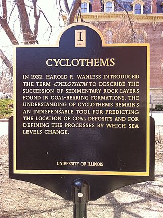
In geology, cyclothems are alternating stratigraphic sequences of marine and non-marine sediments, sometimes interbedded with coal seams. Historically, the term was defined by the European coal geologists who worked in coal basins formed during the Carboniferous and earliest Permian periods. The cyclothems consist of repeated sequences, each typically several meters thick, of sandstone resting upon an erosional surface, passing upwards to pelites and topped by coal.
In geology, a sequence is a stratigraphic unit which is bounded by an unconformity at the top and at the bottom.
Cyclic sediments are sequences of sedimentary rocks that are characterised by repetitive patterns of different rock types (strata) or facies within the sequence. Processes that generate sedimentary cyclicity can be either autocyclic or allocyclic, and can result in piles of sedimentary cycles hundreds or even thousands of metres thick. The study of sequence stratigraphy was developed from controversies over the causes of cyclic sedimentation.
Colorado is a geologic name applied to certain rocks of Cretaceous age in the North America, particularly in the western Great Plains. This name was originally applied to classify a group of specific marine formations of shale and chalk known for their importance in Eastern Colorado. The surface outcrop of this group produces distinctive landforms bordering the Great Plains and it is a significant feature of the subsurface of the Denver Basin and the Western Canadian Sedimentary Basin. These formations record important sequences of the Western Interior Seaway, and as the geology of this seaway was studied, this name came to be used in states beyond Colorado, but was later replaced in several of these states with more localized names.

The Supai Group is a slope-forming section of red bed deposits found in the Colorado Plateau. The group was laid down during the Pennsylvanian to Lower Permian. Cliff-forming interbeds of sandstone are noticeable throughout the group. The Supai Group is especially exposed throughout the Grand Canyon in northwest Arizona, as well as local regions of southwest Utah, such as the Virgin River valley region. It occurs in Arizona at Chino Point, Sycamore Canyon, and famously at Sedona as parts of Oak Creek Canyon. In the Sedona region, it is overlain by the Hermit Formation, and the colorful Schnebly Hill Formation.
The Yegua Formation is a geologic formation in Texas. It preserves fossils dating back to the Paleogene period.

The Drzewica Formation is a geologic formation in Szydłowiec, Poland. It is Pliensbachian in age. Vertebrate fossils have been uncovered from this formation, including dinosaur tracks. The Drzewica Formation is part of the Depositional sequence IV-VII of the late lower Jurassic Polish Basin, with the IV showing the presence of local Alluvial deposits, with possible meandriform deposition origin, dominated in Jagodne and Szydłowiec, while delta system occurred through the zone of the modern Budki. The sequence V shows a reduction of the erosion in the Zychorzyn borehole of the Drzewica Formation, showing changes on the extension of the marine facies, where upper deposits change from Alluvial to Deltaic-Seashore depositional settings. VI-VII facies were recovered on the Brody-Lubienia borehole, with a lower part exposed on the village of Śmiłów that shows a small fall of the Sea level. The stathigraphic setting of the dinosaur tracks reported from the formation suggest a Seashore or Deltaic barrier. Body fossils reported include bivalves, palynology, fossil trunks, roots. Trunks of coniferous wood, especially Cheirolepidiaceae and Araucariaceae trees show the occurrence of vast coniferous forests around the tracksite. The association of forests and dinosaur megafauna on the Pliensbachian suggests also a colder and specially dry ecosystem. Drzewica deposits where in part to be a gigantic shore barrel, setting at the time where the Polish basin sea was at its lowest point. Other related units are Fjerritslev or Gassum Formation, Hasle & Sorthat Formation (Bornholm), upper Neringa Formation (Lithuania). Abandoned informal units in Poland: upper Sawêcin beds, Wieluñ series or Bronów series.
Marine flooding surfaces are a fundamental concept in sequence stratigraphy, where they form the limiting surfaces of parasequences.
Accommodation is a fundamental concept in sequence stratigraphy, a subdiscipline of geology. It is defined as the space that is available for the deposition of sediments. Accommodation space can be pictured as the volume between the actual surface and the theoretical equilibrium surface where deposition and erosion are in balance at every point. In marine environments, this equilibrium level is sea level.
A parasequence is a fundamental concept of sequence stratigraphy. Parasequences are not directly related to sequences.
In sequence stratigraphy, a sub discipline of geology, type 1 sequences and type 2 sequences are special sequences that are defined by having distinct types of sequence boundaries. In modern literature, the distinction in type 1 sequences and type 2 sequences was abandoned.
Stratigraphic paleobiology is a branch of geology that is closely related to paleobiology, sequence stratigraphy and sedimentology. Stratigraphic paleobiology studies how the fossil record is altered by sedimentological processes and how this affects biostratigraphy and paleobiological interpretations of the fossil record.

The Ipubi Formation is the middle geological formation of the Santana Group, the middle part of the Araripe Group, in the Araripe Basin of northeastern Brazil. The formation is dated to the Aptian to Albian stages of the Early Cretaceous, unconformably overlying the Crato Formation and unconformably overlain by the Romualdo Formation, formerly known as the Romualdo Member of the Santana Formation. The averaging 15 metres (49 ft) thick Ipubi Formation comprises shales and sandstones in the lower section and evaporites in the upper part of the formation, deposited in a transgressive to highstand lacustrine environment in the Araripe rift basin.
The geology of Jordan includes thick sedimentary sequences of sandstone, marl and evaporites atop ancient Precambrian crystalline igneous and metamorphic basement rock.
Seismic stratigraphy is a method for studying sedimentary rock in the deep subsurface based on seismic data acquisition.
In sequence stratigraphy, condensed sections are strata that are thin, yet span a large time interval. They are associated with the maximum flooding surfaces, represented by sedimentary intervals deposited during the maximum marine transgression.
References
- ↑ Patzkowsky, Mark E.; Holland, Steven M. (2012). Stratigraphic Paleobiology. Chicago: University of Chicago University Press. p. 220.
- ↑ Catuneanu, Octavian (2011). "Sequence stratigraphy: methodology and nomenclature". Newsletters on Stratigraphy. E. Schweizerbart'sche Verlagsbuchhandlung. 44 (3): 190.
| | This article about stratigraphy is a stub. You can help Wikipedia by expanding it. |