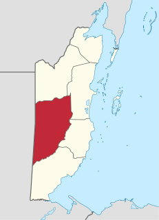
Cayo District is a district located in the west part of Belize. It is the first-most extensive, second-most populous and third-most densely populated of the six districts of Belize. The district's capital is the town of San Ignacio.

Hattieville is a village in the Belize District of the nation of Belize. It is located at 17N 88W, at an elevation of 196 feet above mean sea level, and has a population of about 1,300 people. Hattieville was established as a refugee camp after Hurricane Hattie made many people homeless in Belize City when it hit in 1961, but it became a permanent town.

Ladyville is the largest village in the country of Belize, eight miles northwest of Belize City in the Belize District. The Philip Goldson Highway connects Ladyville to Belize City.
Little Belize is a colony of conservative German-speaking "Russian" Mennonites, known as "Old Colony Mennonites", in the Corozal District of Belize. Little Belize is located east of Progresso at an elevation of 1 meter above sea level. Because the Mennonite colony is close to Progresso, it is sometimes called "Progresso".
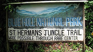
St. Herman's Blue Hole National Park is a national park located just off the Hummingbird Highway in Cayo District of Belize, near Belmopan, the capital city. It is over 500 acres (2 km²) in area, and contains two cave systems, various natural trails, and the cool jungle pool from which the park gets its name. The park is managed by the Belize Audubon Society.
Holy Redeemer Primary School is a Catholic, parish primary school located in the heart of Belize City, Belize.
Indian Church is a small remote village in the Orange Walk District of Belize. It is located on the west bank of New River, neighbouring the town of San Carlos to its south, and the Maya ruins of Lamanai to its north. According to the 2010 census, Indian Church has a population of 267 people in 66 households. The village is named for the historic Spanish churches recovered among the ancient Maya ruins. The residents lived among the ruins until 1991 when the Government of Belize established the 2-square-mile (5.2 km2) Lamanai Archaeological Reserve maintained by Belize's Institute of Archaeology.

Moraleja del Vino is a municipality located in the province of Zamora, Castile and León, Spain. According to the 2004 census (INE), the municipality has a population of 1,315 inhabitants.
The Marylebone Cricket Club Grounds is a Belizean football stadium, located on the Northside of Belize City, Belize.
Gardenia is a village in Belize District, Belize located about 20 miles (32 km) north of Belize City.
St. Ann's Anglican Church is a church in Belmopan, Belize. It is located on Unity Boulevard.
Belize City First Church of the Nazarene is a church in Belize City, Belize. It is located at 3 Albert Street West.
The Maritime Museum is a museum in Belize City, Belize. The museum is located at the North Front St, Marine Terminal at Swing Bridge in the former fire station. The museum opened in 1996.

The Belize City Swing Bridge is a swing bridge located in downtown Belize City, Belize. It connects the north side of Belize City with the south side and spans Haulover Creek, a tributary of the Belize River.
Maskall is a settlement located in the nation of Belize. It is a mainland village located in Belize District. It is 39 miles north of Belize City.
Santana is a settlement located in the nation of Belize. It is a mainland village located in Belize District.
Sandhill, Belize is a populated settlement located in the nation of Belize. It is a mainland village located in the Belize District.
Yarborough Cemetery is an historical cemetery located in Belize City, Belize. It was the first cemetery in British Honduras, used from 1787 until 1896, and was established for the burial of members of the colonial Anglican Church. It was named after the magistrate who owned the land. The cemetery was renovated in 1999 with the addition of perimeter fencing, landscaping and a marble memorial wall highlighting the names and contributions of those buried there. In 2009, the government designated it an archaeological reserve.
The National Archives of Belize are the national archives of Belize. They are located in Belmopan.
This page is based on this
Wikipedia article Text is available under the
CC BY-SA 4.0 license; additional terms may apply.
Images, videos and audio are available under their respective licenses.