
Palo Alto is a charter city in the northwestern corner of Santa Clara County, California, United States, in the San Francisco Bay Area, named after a coastal redwood tree known as El Palo Alto.

Menlo Park is a city at the eastern edge of San Mateo County in the San Francisco Bay Area of California, United States. It is bordered by San Francisco Bay on the north and east; East Palo Alto, Palo Alto, and Stanford to the south; and Atherton, North Fair Oaks, and Redwood City to the west. It had 33,780 residents at the 2020 United States census. It is home to the corporate headquarters of Meta, and is where Google, Roblox Corporation, and Round Table Pizza were founded. The train station holds the record as the oldest continually operating train station in California. It is one of the most educated cities in California and the United States; nearly 70% of residents over 25 have earned a bachelor's degree or higher.

Amasa Leland Stanford was an American attorney, industrialist, philanthropist, and Republican Party politician from California. He served as the 8th governor of California from 1862 to 1863 and represented the state in the United States Senate from 1885 until his death in 1893. He and his wife Jane founded Stanford University, named after their late son.

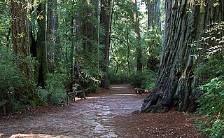
El Palo Alto is a coast redwood located on the banks of the San Francisquito Creek in Palo Alto, California, a city in the San Francisco Bay Area. The namesake of the city and a historical landmark, El Palo Alto is 1083–1084 years old and stands 110 feet (34 m) tall.
Sempervirens Fund, originally established in 1900 as Sempervirens Club, is California's oldest land trust. Founder Andrew P. Hill’s goal was to preserve the old-growth forest that became Big Basin Redwoods State Park, the first California state park in 1902. Sempervirens Fund's mission is to protect and permanently preserve coast redwood forests, wildlife habitat, watersheds, and other important natural features of California's Santa Cruz Mountains, and to encourage people to appreciate and enjoy this environment. Sempervirens Fund does this by purchasing land for protection and transferring it to state or local agencies. Sempervirens Fund has also worked to establish conservation easements and trail linkages between parks and coastal marine preserves. As of 2013, Sempervirens Fund has saved more than 34,000 acres of redwood lands.

The Peninsula Commute, also known as the Southern Pacific Peninsula or just Peninsula, was the common name for commuter rail service between San Jose and San Francisco on the San Francisco Peninsula. This service ran as a private, for-profit enterprise beginning in 1863. Due to operating losses, the Southern Pacific Railroad (SP) petitioned to discontinue the service in 1977. Subsidies were provided through the California Department of Transportation (Caltrans) in 1980 to continue service, and it was renamed Caltrain in 1985.
California's 16th congressional district is a congressional district in the U.S. state of California. It includes portions of Santa Clara and San Mateo counties, extending from the southwestern San Francisco Bay Area through the Santa Cruz Mountains to the Pacific coast. The district is currently represented by Democrat Anna Eshoo.

The Peninsular Railway was an interurban electrified railway in the U.S. State of California in the United States of America. It served the area between San Jose, Los Gatos, and Palo Alto, comprising much of what is today known as "Silicon Valley". For much of its existence it was a subsidiary of the Southern Pacific Railroad.

A Western saloon is a kind of bar particular to the Old West. Saloons served customers such as fur trappers, cowboys, soldiers, lumberjacks, businessmen, lawmen, outlaws, miners, and gamblers. A saloon might also be known as a "watering trough, bughouse, shebang, cantina, grogshop, and gin mill". The first saloon was established at Brown's Hole, Wyoming, in 1822, to serve fur trappers.

San Francisquito Creek is a creek that flows into southwest San Francisco Bay in California, United States. Historically it was called the Arroyo de San Francisco by Juan Bautista de Anza in 1776. San Francisquito Creek courses through the towns of Portola Valley and Woodside, as well as the cities of Menlo Park, Palo Alto, and East Palo Alto. The creek and its Los Trancos Creek tributary define the boundary between San Mateo and Santa Clara counties.

Palo Alto station is an intermodal transit center in Palo Alto, California. It is served by Caltrain regional rail service, SamTrans and Santa Clara VTA local bus service, Dumbarton Express regional bus service, the Stanford University Marguerite Shuttle, and several local shuttle services. Palo Alto is the second-busiest Caltrain station after San Francisco, averaging 7,764 weekday boardings by a 2018 count. The Caltrain station has two side platforms serving the two tracks of the Peninsula Subdivision and a nearby bus transfer plaza.
The Palo Alto Unified School District is a public school district located near Stanford University in Palo Alto, California. It consists of twelve primary schools, three middle schools, two high schools, with a third opening Fall of 2024, and an adult school.

Adobe Creek, historically San Antonio Creek, is a 14.2-mile-long (22.9 km) northward-flowing stream originating on Black Mountain in the Santa Cruz Mountains. It courses through the cities of Los Altos Hills, Los Altos, and Palo Alto on its way to the Palo Alto Flood Basin and thence to southwestern San Francisco Bay in Santa Clara County, California, United States. Historically, Adobe Creek was a perennial stream and hosted runs of steelhead trout entering from the Bay, but these salmonids are now blocked by numerous flood control structures, including a tidal gate at the creek's mouth and a long concretized rectangular channel culminating in an impassable drop structure at El Camino Real. The co-founders of Adobe Systems both lived on Adobe Creek.

Matadero Creek is a stream originating in the foothills of the Santa Cruz Mountains in Santa Clara County, California, United States. The creek flows in a northeasterly direction for 8 miles (13 km) until it enters the Palo Alto Flood Basin, where it joins Adobe Creek in the Palo Alto Baylands at the north end of the Mayfield Slough, just before its culmination in southwest San Francisco Bay. Matadero Creek begins in the city of Los Altos Hills, then traverses the Stanford University lands and Palo Alto.

The Palo Alto Baylands Nature Preserve, known officially as the Baylands Nature Preserve, is the largest tract of undisturbed marshland remaining in the San Francisco Bay. Fifteen miles of multi-use trails provide access to a unique mixture of tidal and fresh water habitats. The preserve encompasses 1,940 acres in both Palo Alto and East Palo Alto, and is owned by the city of Palo Alto, California, United States. It is an important habitat for migratory shorebirds and is considered one of the best birdwatching spots on the West Coast.

Timothy Hopkins was the adopted son of Central Pacific Railroad co-owner Mark Hopkins' widow, Mary Hopkins, and friend of another co-owner Leland Stanford and his wife, Jane. He was one of the founders of Palo Alto and a trustee of Stanford University for over 50 years. His estate is now the site of the Menlo Park Civic Center and of SRI International.
Sarah Wallis, also known as Sarah Armstrong Montgomery Green Wallis (1825–1905) was an early Anglophone settler in California and first President of the California Woman Suffrage Educational Association.
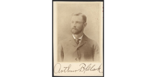
Arthur Bridgman Clark (1866–1948) an American architect, printmaker, author, and professor, as well as the first mayor of Mayfield, California (1855–1925), and first head of Art and Architecture Department at Stanford University. He taught classes at Stanford University from 1893 until 1931.
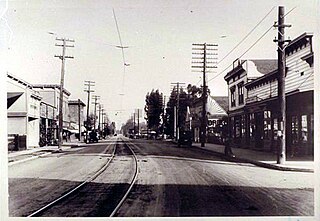
Mayfield was a historic town in Santa Clara County, California. It was one of the oldest towns, predating the establishment of nearby Palo Alto and Stanford University. In 1853, prior to its becoming a town, Elisha Oscar Crosby acquired a 250 acres (1.0 km2) parcel of land, which was named Mayfield Farm. This property later changed hands on September 23, 1856, when it was transferred to Sarah Wallis to settle a debt Crosby owed her. The name "Mayfield" subsequently became associated with the community nearby. The historical significance of Mayfield is now marked by California Historical Landmark #969, which designates the location of Wallis's first residence, the Mayfield Farm.


