This page is based on this
Wikipedia article Text is available under the
CC BY-SA 4.0 license; additional terms may apply.
Images, videos and audio are available under their respective licenses.
Most internal transport in Solomon Islands is conducted through boat travel between islands. Road transport infrastructure is rudimentary, with few paved roads.

The United States Minor Outlying Islands are a statistical designation defined by the International Organization for Standardization's ISO 3166-1 code. The entry code is ISO 3166-2:UM. The minor outlying islands and groups of islands consist of eight United States insular areas in the Pacific Ocean and one in the Caribbean Sea.

An artificial island or man-made island is an island that has been constructed by people rather than formed by natural means. Artificial islands may vary in size from small islets reclaimed solely to support a single pillar of a building or structure, to those that support entire communities and cities. Early artificial islands included floating structures in still waters, or wooden or megalithic structures erected in shallow waters.
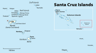
The Santa Cruz Islands are a group of islands in the Pacific Ocean, part of Temotu Province of the Solomon Islands. They lie approximately 250 miles (400 km) to the southeast of the Solomon Islands Chain. The Santa Cruz Islands lie just north of the archipelago of Vanuatu, and are considered part of the Vanuatu rain forests ecoregion.

The Russell Islands are two small islands, as well as several islets, of volcanic origin, in the Central Province of Solomon Islands. They are located approximately 48 kilometres northwest of Guadalcanal. The islands are partially covered in coconut plantations, and have a copra and oil factory at Yandina. Yandina also has basic services, including a store, post office, and airport.
Honiara International Airport, formerly known as Henderson Field, is an airport on Guadalcanal Island in the nation of Solomon Islands. It is the only international airport in the country and is located 8 kilometers from the capital Honiara.

Henderson Field is a former military airfield on Guadalcanal, Solomon Islands during World War II. Originally built by the Japanese, the conflict over its possession was one of the great battles of the Pacific war. Today it is Honiara International Airport.

Bonriki International Airport is an international airport in Kiribati, serving as the main gateway to the country. It is located in its capital, South Tarawa, which is a group of islets in the atoll of Tarawa in the Gilbert Islands.

Santa Isabel Island is the longest in Solomon Islands, the third largest in terms of surface area, and the largest in the group of islands in Isabel Province.

Taro Island is a small island in Solomon Islands with 507 inhabitants, capital of Choiseul Province and is located in Choiseul Bay off the northwest coast.

Palm Island Airport is an airport in Palm Island, on Great Palm Island, Queensland, Australia.
Choiseul Bay Airport is an airport at Choiseul Bay on Taro Island, part of the Choiseul Province in the Solomon Islands.
Kirakira Airport is an airport located at Kirakira on the island of Makira, part of the Makira-Ulawa Province in the Solomon Islands. It is also known as Ngorangora Airstrip and was constructed in the late 1950s. The airport has scheduled flights provided by Solomon Airlines, using DHC-6 Twin Otter aircraft.
Santa Ana Airport is an airport on Santa Ana, an island in the Makira-Ulawa Province in the Solomon Islands. The airport has scheduled flights provided by Solomon Airlines, using DHC-6 Twin Otter aircraft.
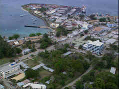
Honiara is the capital city of Solomon Islands, situated on the northwestern coast of Guadalcanal. As of 2017, it had a population of 84,520 people. The city is served by Honiara International Airport and the seaport of Point Cruz, and lies along the Kukum Highway.
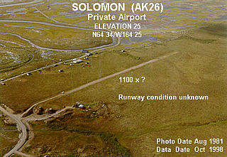
Solomon is an unincorporated community in the Nome Census Area of the Unorganized Borough of Alaska. As of the 2010 census, the population was zero (uninhabited), down from four in 2000.

Solomon Airport is located 15 kilometres (9.3 mi) west of the Karijini National Park, Western Australia.

