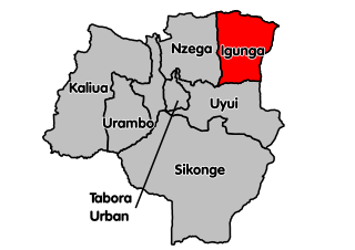
Igunga is one of the seven districts of the Tabora Region of Tanzania. It is bordered to the north by the Shinyanga Region, to the east by the Singida Region, to the south by the Uyui District and to the west by the Nzega District. Its administrative seat is the town of Igunga. Igunga is now divided by two Constituencys: Igunga Constituency and Manonga Constituency, whereby Manonga town is Choma Chankola.
Mbozi District is a district in Songwe Region, Tanzania. It is bordered to the north by Chunya District, to the east by Mbeya Urban and Ileje Districts, to the south by Zambia and to the west by Rukwa Region.
Msia is an administrative ward in Mbozi District, Songwe Region, Tanzania. According to the 2002 census, the ward has a total population of 25,098.
Mlowo is an administrative ward in Mbozi District, Songwe Region, Tanzania. According to the 2002 census, the ward has a total population of 17,663.
Ihanda is an administrative ward in Mbozi District, Songwe Region, Tanzania. According to the 2002 census, the ward has a total population of 25,333.
Chiwezi is an administrative ward in Mbozi District, Songwe Region, Tanzania. According to the 2002 census, the ward has a total population of 12,657.
Ndalambo is an administrative ward in Mbozi District, Songwe Region, Tanzania. According to the 2002 census, the ward has a total population of 9,029.
Nkangamo is an administrative ward in Mbozi District, Songwe Region, Tanzania. According to the 2002 census, the ward has a total population of 8,122.
Itewe is an administrative ward in the Chunya district of the Mbeya Region of Tanzania. According to the 2002 census, the ward has a total population of 5,962.
Kapalala is an administrative ward in Songwe District, Songwe Region, Tanzania. According to the 2002 census, the ward has a total population of 5,924.
Ngwala is an administrative ward in Songwe District, Songwe Region, Tanzania. According to the 2002 census, the ward had a total population of 2,595.
Totowe is an administrative ward in Songwe District, Songwe Region, Tanzania. According to the 2002 census, the ward has a total population of 8,654.
Ikuti is an administrative ward in the Rungwe district of the Mbeya Region of Tanzania. According to the 2002 census, the ward had a total population of 11,300.
Kiwira is an administrative ward in the Rungwe district of the Mbeya Region of Tanzania. According to the 2002 census, the ward has a total population of 2000,119.
Kafule is an administrative ward in Ileje District, Songwe Region, Tanzania. According to the 2002 census, the ward has a total population of 6,892.
Luswisi is an administrative ward in Ileje District, Mbeya Region, Tanzania. According to the 2002 census, the ward has a total population of 4,790.
Mima is an administrative ward in the Mpwapwa district of the Dodoma Region of Tanzania. According to the 2002 census, the ward has a total population of 17,341.
Sagara is an administrative ward in the Kongwa district of the Dodoma Region of Tanzania. According to the 2012 census, the ward has a total population of 23,000.
Sepuka is an administrative ward in the Singida Rural district of the Singida Region of Tanzania. According to the 2002 census, the ward has a total population of 24,315.
Itunundu is an administrative ward in the Iringa Rural district of the Iringa Region of Tanzania. According to the 2002 census, the ward has a total population of 18,962.


