The history of the Republic of the Congo has been marked by diverse civilisations: Indigenous, French and post-independence.

The Republic of the Congo is located in the western part of central Africa, on the Equator. Congo has several important ports. The Republic of the Congo covers an area of 342,000 km², of which 341,500 km² is land while 500 km² is water. Congo claims 200 nautical miles (370 km) of territorial sea.
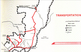
Transport in the Republic of Congo includes land, air and water modes. Over 3,000 km (1,900 mi) of paved roads are in use. The two international airports are Maya-Maya Airport and Pointe Noire Airport.

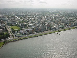
Brazzaville is the capital and largest city of the Republic of the Congo. Administratively, it is a department and a commune. Constituting the financial and administrative centre of the country, it is located on the north side of the Congo River, opposite Kinshasa, the capital city of the Democratic Republic of the Congo.
Libreville is the capital and largest city of Gabon, located on the Gabon Estuary. Libreville occupies 65 square kilometres (25 sq mi) of the northwestern province of Estuaire. Libreville is also a port on the Gabon Estuary, near the Gulf of Guinea. As of the 2013 census, its population was 703,904.

The Trans-Gabon Railway is the only railway in Gabon. It runs 670 km (420 mi) east from Owendo port station in Libreville to Franceville via numerous stations, the main ones being Ndjolé, Lopé, Booué, Lastoursville and Moanda.

Moanda is one of the largest towns in Gabon, lying on the N3 road in Haut Ogooué. It is also one of the most important manganese mining towns in the world, under the auspices of the Compagnie minière de l'Ogooué (COMILOG), which began mining in 1957. Moanda has a population of around 39,298 inhabitants and is the second largest city in the Haut Ogooué Region, after Franceville. It is also a border town, lying 100 km away from the border with the Republic of Congo.

Dolisie, known as Loubomo between 1975 and 1991, is a city and a commune. It is the capital of Niari in the south western of the Republic of the Congo, the country's third largest city and an important commercial centre. The city lies on the eastern edge of the coastal rainforest and has a population of 178,172.

The Congo–Ocean Railway links the Atlantic port of Pointe-Noire with Brazzaville, a distance of 502 kilometres (312 mi). It bypasses the rapids on the lower Congo River; from Brazzaville, river boats are able to ascend the Congo River and its major tributaries, including the Oubangui River to Bangui.
Mossendjo is a town and a commune located in the Niari Department of the Republic of the Congo.
The COMILOG Cableway was one of the longest cableways in the world, until its closure in 1986. The ropeway conveyor ran for 76 km from Moanda in the Haut-Ogooué Province of south eastern Gabon to Mbinda in the Republic of Congo.
Akana is an Enterprise API Management and Cloud Integration provider. Akana may also refer to:

Mayoko District is a district in the Niari Department of south-western Republic of the Congo. The capital lies at Mayoko. It has a northern border with Gabon. As of 2007, the population is 5,147.
Railway stations in the Republic of the Congo (Congo) include:

Congo, officially the Republic of the Congo or Congo Republic, also known as Congo-Brazzaville, is a country located on the western coast of Central Africa to the west of the Congo River. It is bordered to the west by Gabon, to the northwest by Cameroon, to the northeast by the Central African Republic, to the southeast by the Democratic Republic of the Congo, to the south by the Angolan exclave of Cabinda, and to the southwest by the Atlantic Ocean.

The Central African Backbone (CAB) is a fiber-optic Internet backbone connecting the countries of the Economic Community of Central African States (ECCAS) in Africa via high speed internet. The countries included in the CAB project are: Cameroon, the Central African Republic, Chad, Democratic Republic of the Congo, Gabon, Republic of the Congo and São Tomé and Príncipe. It's split up into five phases, each phase focusing on the fibre rollout in one or more countries.
The Monts Avima are a mountain range in the Republic of the Congo near Gabon border to the west, and the Cameroon border to the north. The highest peak is the Mt. Avima in a 40 km west to east oriented ridge with several other top points which exceed 900 m above sea level. These mounts have a significant deposit of iron ore and few small gold placer deposits. The mountain is covered by rain-forest. The forest is inhabited by a small local tribe of native people who live on from hunting and from alluvial gold mining. Between March and September 2009 it was an access road built from Cameroon border to Mt. Avima for a mining exploration program arriving to the top of the mountain. After the exploration program, the road was covered by the rain forest blocking the access by vehicles to the mountain. Due to the significant quantities and qualities of iron ore discovered, it is expected that mining activities will start in the future.

Franco–Congolese relations are the current and historical relationship between the French Republic and the Republic of the Congo. France maintains an embassy in Brazzaville and a consulate in Pointe Noire. France controlled the Republic of the Congo as a colony from the 1880s until the Congo's independence in 1960. Following the collapse of communism worldwide, France has become Congo's most significant external trading partner.
Mbinda is a district in the Niari Department of Republic of the Congo.

