
Berrien County is a county in the U.S. state of Michigan. It is located at the southwest corner of the state's Lower Peninsula, located on the shore of Lake Michigan and sharing a land border with Indiana. As of the 2020 Census, the population was 154,316. The county seat is St. Joseph.

Berrien Township is a civil township of Berrien County in the U.S. state of Michigan. As of the 2020 census, the township population was 4,868.

Bertrand Township is a civil township of Berrien County in the U.S. state of Michigan. As of the 2020 census, the township population was 2,611.

Buchanan is a city in Berrien County in the U.S. state of Michigan. The population was 4,300 at the 2020 census. The city is located at the southeast corner of Buchanan Township, about 5 miles (8.0 km) west of Niles.

Buchanan Township is a civil township of Berrien County in the U.S. state of Michigan. As of the 2020 census, the township population was 3,436. The city of Buchanan is located in the southeast portion of the township.

Galien Township is a civil township of Berrien County in the U.S. state of Michigan. As of the 2020 census, the township population was 1,412. The village of Galien is located within the township.

Niles Charter Township is a charter township of Berrien County in the U.S. state of Michigan. The population was 14,417 at the 2020 census.

Pipestone Township is a civil township of Berrien County in the U.S. state of Michigan. The population was 2,177 at the 2020 census. The township was organized on February 16, 1842.

Sodus Township is a civil township of Berrien County in the U.S. state of Michigan. The population was 1,995 at the 2020 census. There are no incorporated municipalities in the township. The unincorporated community of Sodus in the northwest of the township is its main settlement; the portion of the township just to the west is part of the Benton Harbor/St. Joseph urban area.

Weesaw Township is a civil township of Berrien County in the U.S. state of Michigan. The population was 1,832 at the 2020 census. The township was organized in 1837, and was named after Weesaw, a local Potawatomi chief.
The Paw Paw River is located in the U.S. state of Michigan in the southwest portion of the lower peninsula. It is formed by the confluence of the north and south branches at 42°15′17″N85°55′36″W in Waverly Township in the northeast of Van Buren County. It flows approximately 61.8 miles (99.5 km) through Van Buren County and Berrien County until joining the St. Joseph River just above its mouth on Lake Michigan at Benton Harbor.

The St. Joseph River is an 86.1-mile-long (138.6 km) tributary of the Maumee River in northwestern Ohio and northeastern Indiana in the United States, with headwater tributaries rising in southern Michigan. It drains a primarily rural farming region in the watershed of Lake Erie.
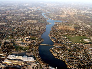
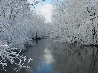
The St. Joseph River is a 210-mile-long (340 km) river that flows in a generally westerly direction through southern Michigan and northern Indiana, United States, before emptying into Lake Michigan. The St. Joseph River drainage basin covers 4,685 square miles (12,130 km2), and is the third largest watershed draining to Lake Michigan. The land within its bounds is primarily used for agriculture. The river and its tributaries provide a variety of paddling and fishing environments. Historically, the river served as an important canoe transportation route for various Native American tribes, and for French Canadian Voyageurs.

The Dowagiac River is a southwesterly flowing 30.9-mile-long (49.7 km) stream in the Lower Peninsula of the U.S. state of Michigan. It is a tributary to the St. Joseph River which flows, in turn, into eastern Lake Michigan.
Coldwater River is a 29.5-mile-long (47.5 km) stream in the U.S. state of Michigan. Located in Branch County, the river rises in Ovid Township at 41°50′14″N84°59′13″W as the outflow of Coldwater Lake. Flowing north and west, it is joined by the outflow from the Lake of the Woods and continues north for several miles. West of the city of Coldwater, it flows through a series of lakes: South Lake, Messenger Lake, Cemetery Lake, North Lake, Randall Lake, Morrison Lake, Craig Lake, and Hodunk Pond. It then continues to the northwest and empties into the St. Joseph River in the village of Union City at 42°03′58″N85°07′48″W.

Clay Township is one of 13 townships in St. Joseph County, in the U.S. state of Indiana. As of the 2020 census, its population was 34,235.

Olive Township is one of thirteen townships in St. Joseph County, in the U.S. state of Indiana. As of the 2000 census, its population was 3,914.
Warren Township is one of thirteen townships in St. Joseph County, in the U.S. state of Indiana. As of the 2000 census, its population was 6,430.

Arroyo Calabasas is a 7.0-mile-long (11.3 km) tributary of the Los Angeles River, in the southwestern San Fernando Valley area of Los Angeles County in California.
Lemon Creek is a stream in Berrien County, in the U.S. state of Michigan. It is a tributary to the St. Joseph River.
