Related Research Articles
Klamath County is one of the 36 counties in the U.S. state of Oregon. As of the 2020 census, the population was 69,413. The county seat is Klamath Falls. The county was named for the Klamath, the tribe of Native Americans living in the area at the time the first European explorers entered the region. Klamath County comprises the Klamath Falls, OR Micropolitan Statistical Area.

Klamath Falls is a city in, and the county seat of, Klamath County, Oregon, United States. The city was originally called Linkville when George Nurse founded the town in 1867. It was named after the Link River, on whose falls the city was sited. The name was changed to Klamath Falls in 1893. The population was 21,813 at the 2020 census. The city is on the southeastern shore of the Upper Klamath Lake. It is located 80 miles (130 km) east of Medford, 250 miles (400 km) northwest of Reno, and approximately 10 miles (16 km) north of the California–Oregon border.

Klamath County was a county of California from 1851 to 1874. During its existence, the county seat moved twice and ultimately portions of the territory it once had were carved up and added to nearby counties. It was formed from the northwestern portion of Trinity County, and originally included all of the northwestern part of the state, from the Mad River in the south to Oregon in the north, from the Pacific Ocean in the west to the middle of what is now Siskiyou County in the east. It is the only county in California to be disestablished.

The Modoc are an Indigenous American people who historically lived in the area which is now northeastern California and central Southern Oregon. Currently, they include two federally recognized tribes, the Klamath Tribes in Oregon and the Modoc Tribe of Oklahoma, now known as the Modoc Nation.

The Klamath Mountains are a rugged and lightly-populated mountain range in northwestern California and southwestern Oregon in the western United States. As a mountain system within both the greater Pacific Coast Ranges and the California Coast Ranges, the Klamath Mountains have a varied geology, with substantial areas of serpentinite and marble, and a climate characterized by moderately cold winters with very heavy snowfall and warm, very dry summers with limited rainfall, especially in the south. As a consequence of the geology and soil types, the mountains harbor several endemic or near-endemic trees, forming one of the largest collections of conifers in the world. The mountains are also home to a diverse array of fish and animal species, including black bears, large cats, owls, eagles, and several species of Pacific salmon. Millions of acres in the mountains are managed by the United States Forest Service. The northernmost and largest sub-range of the Klamath Mountains are the Siskiyou Mountains.
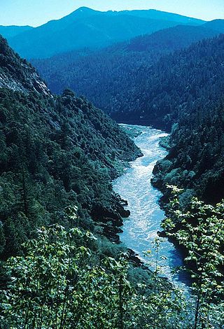
The Klamath River flows 257 miles (414 km) through Oregon and northern California in the United States, emptying into the Pacific Ocean. By average discharge, the Klamath is the second largest river in California after the Sacramento River. Its nearly 16,000-square-mile (41,000 km2) watershed stretches from the high desert of south-central Oregon to the temperate rainforest of the North Coast. Unlike most rivers, the Klamath begins in a desert region and flows through the rugged Cascade Range and Klamath Mountains before reaching the ocean; National Geographic magazine has called the Klamath "a river upside down".

Upper Klamath Lake is a large, shallow freshwater lake east of the Cascade Range in south-central Oregon in the United States. The largest body of fresh water by surface area in Oregon, it is approximately 25 miles (40 km) long and 8 miles (13 km) wide and extends northwest from the city of Klamath Falls. It sits at an average elevation of 4,140 feet (1,260 m).
Weitchpec ( WETCH-pek is an unincorporated community within the Yurok reservation in Humboldt County, California, United States. It is located 35 miles northeast of Eureka, at an elevation of 361 feet. The ZIP Code is 95546.

Klamath National Forest is a 1,737,774-acre national forest, in the Klamath Mountains and Cascade Range, located in Siskiyou County in northern California, but with a tiny extension into southern Jackson County in Oregon. The forest contains continuous stands of ponderosa pine, Jeffrey pine, Douglas fir, red fir, white fir, lodgepole pine, Baker Cypress, and incense cedar. Old growth forest is estimated to cover some 168,000 acres (680 km2) of the forest land. Forest headquarters are located in Yreka, California. There are local ranger district offices located in Fort Jones, Happy Camp, and Macdoel, all in California. The Klamath was established on May 6, 1905. This forest includes the Kangaroo Lake and the Sawyers Bar Catholic Church is located within the boundaries of the Forest. The Forest is managed jointly with the Butte Valley National Grassland.

The Six Rivers National Forest is a U.S. National Forest located in the northwestern corner of California. It was established on June 3, 1947 by U.S. President Harry S. Truman from portions of Klamath, Siskiyou and Trinity National Forests. Its over one million acres (4,000 km2) of land contain a variety of ecosystems and 137,000 acres (550 km2) of old growth forest. It lies in parts of four counties; in descending order of forestland area they are Del Norte, Humboldt, Trinity, and Siskiyou counties. The forest is named after the Eel, Van Duzen, Klamath, Trinity, Mad, and Smith rivers, which pass through or near the forest's boundaries.

State Route 169 is a state highway in the U.S. state of California that is separated into two distinct segments by undeveloped areas in the Yurok Indian Reservation in Del Norte and Humboldt counties. The western segment runs from U.S. Route 101 near Klamath to Klamath Glen, while the eastern segment goes from Wautec Village to State Route 96 near Weitchpec.
The Klamath Tribes, formerly the Klamath Indian Tribe of Oregon, are a federally recognized Native American Nation consisting of three Native American tribes who traditionally inhabited Southern Oregon and Northern California in the United States: the Klamath, Modoc, and Yahooskin. The tribal government is based in Chiloquin, Oregon.

The Klamath Basin is the region in the U.S. states of Oregon and California drained by the Klamath River. It contains most of Klamath County and parts of Lake and Jackson counties in Oregon, and parts of Del Norte, Humboldt, Modoc, Siskiyou, and Trinity counties in California. The 15,751-square-mile (40,790 km2) drainage basin is 35% in Oregon and 65% in California. In Oregon, the watershed typically lies east of the Cascade Range, while California contains most of the river's segment that passes through the mountains. In the Oregon-far northern California segment of the river, the watershed is semi-desert at lower elevations and dry alpine in the upper elevations. In the western part of the basin, in California, however, the climate is more of temperate rainforest, and the Trinity River watershed consists of a more typical alpine climate.

Keno is an unincorporated community in Klamath County, Oregon, United States, southwest of Klamath Falls on the Klamath River near Oregon Route 66. As of 2000, the population was 1,059. Keno's elevation is 4,108 feet (1,252 m) above sea level.

Klamath Community College (KCC) is a public community college in Klamath Falls, Oregon. KCC's primary service area is Klamath County and Lake County in South Central Oregon. The majority of Klamath County is its official service area, while KCC has a "contract out of district" (COD) with Lake County.

The Richmond–San Rafael Ferry Company was a ferry service between Castro Point in Richmond in Contra Costa County and San Quentin in Marin County, California across the San Pablo Bay. It ran from 1915 until the 1956 opening of the Richmond–San Rafael Bridge.

The Upper Klamath National Wildlife Refuge is a wildlife refuge in southwestern Klamath County on the shores of Upper Klamath Lake in Oregon. It was established in 1928 and contains some 14,400 acres (5,800 ha) of freshwater marshes. It is accessible only by boat from Rocky Point Resort and Rocky Point boat launch, Malone springs, and a few neighboring ramps. The refuge is part of the Klamath Basin National Wildlife Refuge Complex and is administered along with the other refuges of the complex from common offices in Tulelake, California.
Martins Ferry is a former settlement in Klamath County and later in Humboldt County, California. It lay on the Klamath River, at an elevation of 315 feet. It still appeared on maps as of 1983.
Young's Ferry was a settlement in Klamath County on the Klamath River down stream from Weitchpec and McDonald's Ferry. On May 19, 1855, it was described by the Weekly Humboldt Times as being on the upstream boundary of the proposed Klamath River Indian Reservation. That reservation was described as extending 20 miles along the Klamath River from its mouth at the Pacific Ocean and one mile wide along each side of the river.
References
| | This Humboldt County, California–related article is a stub. You can help Wikipedia by expanding it. |