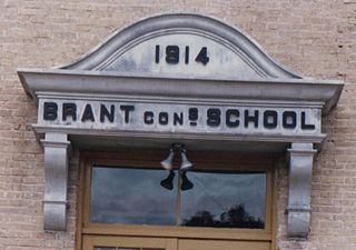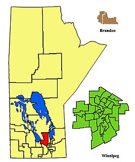
Lakeside is a provincial electoral division in Manitoba, Canada. It is located to the immediate northwest of the city of Winnipeg.
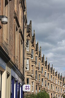
Marchmont is a mainly residential affluent area of Edinburgh, Scotland. It lies roughly a mile to the south of the Old Town, separated from it by The Meadows and Bruntsfield Links. To the west it is bounded by Bruntsfield; to the south-southwest by Greenhill and then Morningside; to the south-southeast by The Grange; and to the east by Sciennes. The name derives from the wife of Sir George Warrender who was daughter to Hume Campbell of Marchmont. Marchmont is an archaic name for Roxburgh Castle, a now destroyed royal fortress in the Scottish marches.
River East Transcona School Division (RETSD) is a school division located in Winnipeg, Manitoba. It is the second largest school division in the province. It is composed of parts of what used to be two separate divisions the Transcona part of the Transcona-Springfield School Division and River East School Division, which merged in 2002.

Uddingston is a small town in South Lanarkshire, Scotland. It is on the north side of the River Clyde, about 7 miles (11 km) south-east of Glasgow city centre. Uddingston acts as a dormitory suburb for the city.
Darlingford is an unincorporated community recognized as a local urban district located about 15 km west of Morden, Manitoba in the Rural Municipality of Pembina in the Pembina Valley region of southern Manitoba, Canada. The postal code for Darlingford is R0G 0L0.

Manitoba's Interlake is the name given to a region in the Canadian province of Manitoba. As the name indicates, it lies roughly between Lake Winnipeg and Lake Manitoba and comprises 14 rural municipalities, one city, six towns and one village, Dunnottar. The largest population centre in the region is Selkirk. The second largest is the town of Stonewall. The region is divided into three of Statistics Canada's census divisions of Canada: Manitoba Census Divisions No. 13, No. 14, and No. 18, which together had a population of 91,743 at the 2016 census. The total land area of the region is 15,855.37 km².

Arborg is a town located in the Rural Municipality of Bifrost in Manitoba's Interlake Region, 103 kilometres north of Winnipeg.
Binscarth is an unincorporated urban community in the Municipality of Russell – Binscarth within the Canadian province of Manitoba that held village status prior to January 1, 2015. It is located approximately 167 kilometres (104 mi) northwest of Brandon and 16 kilometres (9.9 mi) south from Russell.
The Royal Aviation Museum of Western Canada is a museum in Winnipeg, Manitoba, Canada. The museum is temporarily closed for relocation, and is scheduled to reopen in 2020.

Rockwood is a rural municipality lying north of Winnipeg, Manitoba, Canada. It is part of the Winnipeg Capital Region and had a 2011 census population of 7,964. The independently governed towns of Stonewall and Teulon are both enclaved within Rockwood.
Winnipeg General Hospital is a hospital that was founded in 1872 in Winnipeg, Manitoba. It was built on the estate of Andrew McDermot. The driving force behind the hospital was McDermott's son-in-law Andrew Bannatyne.
Armstrong is a rural municipality in the province of Manitoba in Western Canada. It lies in the southern area of the Interlake and was named after James William Armstrong, a Manitoba politician.
Lowe Farm is a growing farming community in southern Manitoba, Canada. It is located in the Rural Municipality of Morris, 10 minutes west of Morris, Manitoba, on highway #23. It was founded in the 1880s, when John Lowe managed a campaign to attract immigrants, particularly farmers and farm laborers for Manitoba. Lowe Farm became a model farm and a testing ground for farming innovations and later developed into a village.

Glenurquhart or Glen Urquhart is a glen running to the west of the village of Drumnadrochit in the Highland council area of Scotland.
Settlers, Rails & Trails Inc. is a community-run, non-profit museum located in Argyle, Manitoba. It exhibits local history, railway and agricultural artifacts and historical information, and it is also home to the Canadian Flag Collection. Argyle is governed by the Rural Municipality of Rockwood, and is located approximately 28 km northwest of Winnipeg, within the Manitoba Capital Region.
Brandon House was a Hudson's Bay Company post or posts from 1793 to 1824. It was located at several places on the Assiniboine River between Brandon, Manitoba and the mouth of the Souris River about 21 miles southeast of Brandon. Because of its location near the Souris River it was a center for trade with the Mandans in North Dakota. It was moved four times and there were related forts nearby, so its history is necessarily complex. For background see Assiniboine River fur trade.

The Canadian Flag Collection is the special exhibit of Settlers, Rails & Trails Inc, the museum located in Argyle, Manitoba, Canada. It is the 2nd largest museum flag collection in Canada, second only to the Canadian Museum of History in Gatineau, Quebec, Canada.