
KwaZulu-Natal is a province of South Africa that was created in 1994 when the government merged the Zulu bantustan of KwaZulu and Natal Province.

Isandlwana is an isolated hill in the KwaZulu-Natal province of South Africa. It is located 169 kilometres (105 mi) north by northwest of Durban. The name is said to mean abomasum, the second stomach of the cow, because it reminded the Zulus of its shape.
KwaDukuza, previously known as Stanger, is a town in KwaZulu-Natal, South Africa. In 2006, the municipal name was changed to KwaDukuza, but the Zulu people in the area called it "Dukuza" well before then.

Umgababa is a rural community area with a large marketplace for tourists in KwaZulu-Natal, South Africa. It forms part of eThekwini.

oThongathi, previously and still commonly known as Tongaat, is a town in KwaZulu-Natal, South Africa, about 40 kilometres (25 mi) north of Durban and 28 kilometres (17 mi) south of KwaDukuza. It now forms part of eThekwini Metropolitan Municipality, or the Greater Durban area. The area is home to the oldest Indian community in South Africa, having been where the first indentured Indian laborers settled in 1860 to work in the sugar-cane plantations. Much of the architectural style in the town was the work of Ivan Mitford-Barberton, and many buildings are in the Cape Dutch style of architecture.

eMdloti, alternatively rendered Umdloti and also known as Umdloti Beach, is a small resort village situated along the KwaZulu-Natal North Coast, South Africa. It lies at the mouth of the Mdloti River approximately 24 km north-east of Durban and 11 km north-east of uMhlanga and now forms part of eThekwini, the Greater Durban Metropolitan Municipality.

Verulam is a town 24 kilometres north of Durban in KwaZulu-Natal, South Africa and forms part of the eThekwini Metropolitan Municipality, governing the Greater Durban metropolitan area.

The Ohlanga River is a river in KwaZulu-Natal, South Africa, which empties into the Indian Ocean just north of uMhlanga, north of Durban. The river has extensive reed beds in the estuary at its mouth, which is only 7 km southwest from the mouth of the uMdloti River. Presently, this river is part of the Mvoti to Umzimkulu Water Management Area.

Blood/Ncome River is situated between Nquthu and Vryheid in KwaZulu-Natal, South Africa. This river has its sources in the hills south-east of Utrecht; leaving the highlands it is joined by two important tributaries that originate in the Schurveberg, after which it flows meandering through a sandy plain. The Blood River is a tributary of the Buffalo River, which is a tributary of the Thukela River which it joins from the north-east.

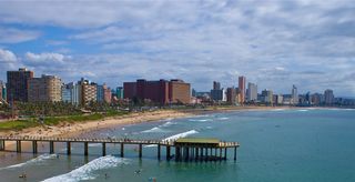
uMhlanga, alternatively rendered Umhlanga, is a residential, commercial and resort town north of Durban on the coast of KwaZulu-Natal, South Africa. It is part of the eThekwini Metropolitan Municipality, which was created in 2000 and includes the greater Durban area. The name means "place of reeds" in the Zulu language, and the correct pronunciation of "hl" in uMhlanga is similar to the Welsh "ll".
Crawford College, North Coast is an alternative, independent school in Westbrook, between oThongathi, Ballito and eMdloti on the North Coast of KwaZulu-Natal, South Africa. The school is owned by the ADvTECH Group and is run as a for-profit business enterprise.

The Zulu Kingdom, sometimes referred to as the Zulu Empire or the Kingdom of Zululand, was a monarchy in Southern Africa. During the 1810s, Shaka established a standing army that consolidated rival clans and built a large following which ruled a wide expanse of Southern Africa that extended along the coast of the Indian Ocean from the Tugela River in the south to the Pongola River in the north.
The M4 is a north–south metropolitan route in the eThekwini Metropolitan Municipality and partially in the KwaDukuza Local Municipality, South Africa. It runs from the N2 at the defunct Durban International Airport to Ballito via the Durban Central Business District (CBD) and uMhlanga. The sections between the airport and the southern edge of the CBD, and between the northern edge of the CBD and the exit to uMhlanga are classified as freeway. On the section from the southern edge of the CBD to the Bram Fischer Street/Soldier's Way junction, the M4 is cosigned with the R102.
Hazelmere Dam is a combined concrete gravity type dam located on the Mdloti River, Kwazulu Natal, South Africa. It was established in 1977 and its primary purpose is to serve for irrigation and domestic use. The hazard potential of the dam assembly has been ranked high (3).

UMshwathi Local Municipality is situated in UMgungundlovu District Municipality (UMDM) which is in the foothills of the province of KwaZulu-Natal, about 120 km northwest of Durban, geographically located between the N2 and the N3 highways. The municipality is the largest Municipality in the largest district of KZN out of the seven Local Municipalities which form UMDM.

The KwaZulu-Natal National Botanical Garden is situated along Mayor's Walk, in the western suburbs of Pietermaritzburg, South Africa. The identification code of the KwaZulu-Natal National Botanical Garden as a member of the Botanic Gardens Conservation International (BGCI), as well as the initials of its herbarium is NBGN .
This is a list of seaside resorts in South Africa. These seaside resorts are in the Eastern Cape, KwaZulu-Natal, Northern Cape and Western Cape provinces which are all coastal provinces of South Africa.
The M27 also known as Jabu Ngcobo Drive or Old Inanda Road is a metropolitan route in the eThekwini Metropolitan Municipality, South Africa linking Inanda to Verulam and eMdloti, north of Durban.
Sibaya Casino and Entertainment Kingdom is an entertainment complex situated just north of uMhlanga and south-west of eMdloti on the North Coast of KwaZulu-Natal, South Africa.

