Measure Map Pro format

Last updated
Measure Map Pro
MMP file.png
Filename extensions .mmp
Internet media type
  • net.victoralonso.measuremappro.mmp
Developed by Blue Blink One.
Type of format GIS file format
Extended from XML

Measure Map Pro format (MMP) is an XML notation to store GIS information in two-dimensional or three-dimensional maps. It was created by Blue Blink One to store information about Polygons, Polylines and Spots including georeferenced labelling, grids and comments.

XML Markup language developed by the W3C for encoding of data

Extensible Markup Language (XML) is a markup language that defines a set of rules for encoding documents in a format that is both human-readable and machine-readable. The World Wide Web Consortium's XML 1.0 Specification of 1998 and several other related specifications—all of them free open standards—define XML.

Contents

Structure

The MMP file includes a set of geometries (Polygon, Polylines, Spots) that can be represented on a map and are georeferenced using WGS84 coordinates. It includes RGB colors for lines and areas and information associated to the geometries.

An example MMP document is:

<?xml version="1.0" encoding="UTF-8"?><POLYGONS><DATE>Nov 4, 2019 at 12:06:52 PM</DATE><POLYGON><NAME>Polygon 1</NAME><DESCRIPTION>This is polygon 1</DESCRIPTION><ISHOLE>0</ISHOLE><BLOCKED>1</BLOCKED><SHAPE>0</SHAPE><NOSURFACE>0</NOSURFACE><SHOWPINS>0</SHOWPINS><SHOWDISTANCES>1</SHOWDISTANCES><LINECOLOR>0</LINECOLOR><LINECUSTOMCOLOR>FF0000</LINECUSTOMCOLOR><LINEWIDTH>3</LINEWIDTH><AREACOLOR>1</AREACOLOR><AREACUSTOMCOLOR>0000FF</AREACUSTOMCOLOR><AREATRANSPARENCY>7</AREATRANSPARENCY><SHOWNAME>1</SHOWNAME><SHOWAREAMEASURE>1</SHOWAREAMEASURE><SHOWPERIMETERMEASURE>1</SHOWPERIMETERMEASURE><COORDINATEPOLYGONLABELLATITUDE>39.483491319510904</COORDINATEPOLYGONLABELLATITUDE><COORDINATEPOLYGONLABELLONGITUDE>-0.38401111640411045</COORDINATEPOLYGONLABELLONGITUDE><COORDINATEPERIMETERLABELLATITUDE>-0.62838414457228</COORDINATEPERIMETERLABELLATITUDE><COORDINATEPERIMETERLABELLONGITUDE>0.0</COORDINATEPERIMETERLABELLONGITUDE><COORDINATEAREALABELLATITUDE>-1.099626787266999</COORDINATEAREALABELLATITUDE><COORDINATEAREALABELLONGITUDE>0.0</COORDINATEAREALABELLONGITUDE><POINTS><POINT><LAT>39.483425319129395</LAT><LONG>-0.38431018270924255</LONG></POINT><POINT><LAT>39.48365200038984</LAT><LONG>-0.38408890046557076</LONG></POINT><POINT><LAT>39.483490528882754</LAT><LONG>-0.38371205009897835</LONG><DESCPOINT><SHOWDESC>1</SHOWDESC><SHOWDESCINREPORT>1</SHOWDESCINREPORT><DESC>This is a description</DESC><DESCLAT>39.483490528882754</DESCLAT><DESCLONG>-0.38371205009897835</DESCLONG></DESCPOINT></POINT><POINT><LAT>39.48333063863197</LAT><LONG>-0.38400522864250775</LONG></POINT><POINT><LAT>39.483425319129395</LAT><LONG>-0.38431018270924255</LONG></POINT></POINTS><GRID><CELLWIDTH>3.048000000000003</CELLWIDTH><CELLHEIGHT>3.048000000000003</CELLHEIGHT><BEARING>0.0</BEARING><REFLATITUDE>39.48348022551208</REFLATITUDE><REFLONGITUDE>-0.38402675914213347</REFLONGITUDE><SHOWGRID>1</SHOWGRID></GRID></POLYGON><POLYGON><NAME>Polygon 3</NAME><ISHOLE>0</ISHOLE><BLOCKED>1</BLOCKED><SHAPE>0</SHAPE><NOSURFACE>0</NOSURFACE><SHOWPINS>0</SHOWPINS><SHOWDISTANCES>1</SHOWDISTANCES><LINECOLOR>0</LINECOLOR><LINECUSTOMCOLOR>FF0000</LINECUSTOMCOLOR><LINEWIDTH>3</LINEWIDTH><AREACOLOR>1</AREACOLOR><AREACUSTOMCOLOR>0000FF</AREACUSTOMCOLOR><AREATRANSPARENCY>7</AREATRANSPARENCY><SHOWNAME>1</SHOWNAME><SHOWAREAMEASURE>1</SHOWAREAMEASURE><SHOWPERIMETERMEASURE>0</SHOWPERIMETERMEASURE><COORDINATEPOLYGONLABELLATITUDE>39.48394123166483</COORDINATEPOLYGONLABELLATITUDE><COORDINATEPOLYGONLABELLONGITUDE>-0.38271287370835694</COORDINATEPOLYGONLABELLONGITUDE><COORDINATEPERIMETERLABELLATITUDE>0.0</COORDINATEPERIMETERLABELLATITUDE><COORDINATEPERIMETERLABELLONGITUDE>0.0</COORDINATEPERIMETERLABELLONGITUDE><COORDINATEAREALABELLATITUDE>39.48385075907382</COORDINATEAREALABELLATITUDE><COORDINATEAREALABELLONGITUDE>-0.38271287370835694</COORDINATEAREALABELLONGITUDE><POINTS><POINT><LAT>39.48410602155221</LAT><LONG>-0.38301848908864145</LONG></POINT><POINT><LAT>39.4842805036605</LAT><LONG>-0.3825395521091366</LONG></POINT><POINT><LAT>39.48377773550993</LAT><LONG>-0.38240725832807243</LONG></POINT><POINT><LAT>39.48360195966916</LAT><LONG>-0.38291298898477066</LONG></POINT><POINT><LAT>39.48410602155221</LAT><LONG>-0.38301848908864145</LONG></POINT></POINTS><GRID><CELLWIDTH>6.096000000000006</CELLWIDTH><CELLHEIGHT>6.096000000000006</CELLHEIGHT><BEARING>0.0</BEARING><REFLATITUDE>39.48388639368251</REFLATITUDE><REFLONGITUDE>-0.38272089261207287</REFLONGITUDE><SHOWGRID>1</SHOWGRID></GRID></POLYGON><SPOT><NAME>spot 1</NAME><SHOWNAME>1</SHOWNAME><ICON>0</ICON><LAT>39.48380422970726</LAT><LONG>-0.3833288364170926</LONG><COORDINATESPOTNAMELATITUDE>39.483762826883066</COORDINATESPOTNAMELATITUDE><COORDINATESPOTNAMELONGITUDE>-0.3833288364170926</COORDINATESPOTNAMELONGITUDE><ALT>-0.3833288364170926</ALT></SPOT><SPOT><NAME>Spot 2</NAME><SHOWNAME>1</SHOWNAME><ICON>0</ICON><LAT>39.483327514732565</LAT><LONG>-0.3835867896154639</LONG><COORDINATESPOTNAMELATITUDE>39.48331716395788</COORDINATESPOTNAMELATITUDE><COORDINATESPOTNAMELONGITUDE>-0.3835867896154639</COORDINATESPOTNAMELONGITUDE><ALT>-0.3835867896154639</ALT></SPOT></POLYGONS>

Geodetic reference systems in MMP

For its reference system, MMP uses 3D geographic coordinates: longitude, latitude and altitude, in that order, with negative values for west, south and below mean sea level if the altitude data is available. The longitude, latitude components (decimal degrees) are as defined by the World Geodetic System of 1984 (WGS84). The vertical component (altitude) is measured in meters from the WGS84 EGM96 Geoid vertical datum.

World Geodetic System geodetic reference system

The World Geodetic System (WGS) is a standard for use in cartography, geodesy, and satellite navigation including GPS. This standard includes the definition of the coordinate system's fundamental and derived constants, the ellipsoidal (normal) Earth Gravitational Model (EGM), a description of the associated World Magnetic Model (WMM), and a current list of local datum transformations.

See also

Keyhole Markup Language (KML) is an XML notation for expressing geographic annotation and visualization within Internet-based, two-dimensional maps and three-dimensional Earth browsers. KML was developed for use with Google Earth, which was originally named Keyhole Earth Viewer. It was created by Keyhole, Inc, which was acquired by Google in 2004. KML became an international standard of the Open Geospatial Consortium in 2008. Google Earth was the first program able to view and graphically edit KML files. Other projects such as Marble have also started to develop KML support.

Geography Markup Language used to describe geographical features

The Geography Markup Language (GML) is the XML grammar defined by the Open Geospatial Consortium (OGC) to express geographical features. GML serves as a modeling language for geographic systems as well as an open interchange format for geographic transactions on the Internet. Key to GML's utility is its ability to integrate all forms of geographic information, including not only conventional "vector" or discrete objects, but coverages and sensor data.

A geospatial content management system (GeoCMS) is a content management system where objects can have a latitude, longitude position to be displayed on an online interactive map. In addition the online maps link to informational pages on the data represented. Some GeoCMS do also allow users to edit spatial data as part of content objects. Spatial data can be published by GeoCMS as part of their contents or using standardized interfaces such as WMS or WFS.

Related Research Articles

Geographic coordinate system Coordinate system

A geographic coordinate system is a coordinate system that enables every location on Earth to be specified by a set of numbers, letters or symbols. The coordinates are often chosen such that one of the numbers represents a vertical position and two or three of the numbers represent a horizontal position; alternatively, a geographic position may be expressed in a combined three-dimensional Cartesian vector. A common choice of coordinates is latitude, longitude and elevation. To specify a location on a plane requires a map projection.

Hexagon shape with six sides

In geometry, a hexagon is a six-sided polygon or 6-gon. The total of the internal angles of any simple (non-self-intersecting) hexagon is 720°.

In computing, a symbolic link is a term for any file that contains a reference to another file or directory in the form of an absolute or relative path and that affects pathname resolution.

Ordnance Survey National Grid System of geographic grid references used in Great Britain

The Ordnance Survey National Grid reference system is a system of geographic grid references used in Great Britain, distinct from latitude and longitude. It is often called British National Grid (BNG).

A GIS file format is a standard of encoding geographical information into a computer file. They are created mainly by government mapping agencies or by GIS software developers.

A geocode is a code that represents a geographic entity. It is a unique identifier of the entity, to distinguish it from others in a finite set of geographic entities. In general the geocode is a human-readable and short identifier.

The Natural Area Code is a proprietary geocode system for identifying an area anywhere on the Earth, or a volume of space anywhere around the Earth. The use of thirty alphanumeric characters instead of only ten digits makes a NAC shorter than its numerical latitude/longitude equivalent.

Geodetic datum reference frame used in geodesy, surveying, chartography and navigation

A geodetic datum or geodetic system is a coordinate system, and a set of reference points, used to locate places on the Earth. An approximate definition of sea level is the datum WGS 84, an ellipsoid, whereas a more accurate definition is Earth Gravitational Model 2008 (EGM2008), using at least 2,159 spherical harmonics. Other datums are defined for other areas or at other times; ED50 was defined in 1950 over Europe and differs from WGS 84 by a few hundred meters depending on where in Europe you look. Mars has no oceans and so no sea level, but at least two martian datums have been used to locate places there.

Geotagging Act of associating geographic coordinates to digital media

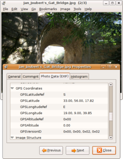
Geotagging, or GeoTagging, is the process of adding geographical identification metadata to various media such as a geotagged photograph or video, websites, SMS messages, QR Codes or RSS feeds and is a form of geospatial metadata. This data usually consists of latitude and longitude coordinates, though they can also include altitude, bearing, distance, accuracy data, and place names, and perhaps a time stamp.

In the Domain Name System, a LOC record is a means for expressing geographic location information for a domain name.

Shapefile package of file formats which together define geographic features

The shapefile format is a geospatial vector data format for geographic information system (GIS) software. It is developed and regulated by Esri as a mostly open specification for data interoperability among Esri and other GIS software products. The shapefile format can spatially describe vector features: points, lines, and polygons, representing, for example, water wells, rivers, and lakes. Each item usually has attributes that describe it, such as name or temperature.

VMDS abbreviates the relational database technology called Version Managed Data Store provided by GE Energy as part of its Smallworld technology platform and was designed from the outset to store and analyse the highly complex spatial and topological networks typically used by enterprise utilities such as power distribution and telecommunications.

Georeferencing means that the internal coordinate system of a map or aerial photo image can be related to a ground system of geographic coordinates. The relevant coordinate transforms are typically stored within the image file, though there are many possible mechanisms for implementing georeferencing. The most visible effect of georeferencing is that display software can show ground coordinates and also measure ground distances and areas. In other words, Georeferencing means to associate something with locations in physical space. The term is commonly used in the geographic information systems field to describe the process of associating a physical map or raster image of a map with spatial locations. Georeferencing may be applied to any kind of object or structure that can be related to a geographical location, such as points of interest, roads, places, bridges, or buildings.

Polygonal chain connected series of line segments

In geometry, a polygonal chain is a connected series of line segments. More formally, a polygonal chain P is a curve specified by a sequence of points called its vertices. The curve itself consists of the line segments connecting the consecutive vertices.

In the Unicode standard, a plane is a continuous group of 65,536 (216) code points. There are 17 planes, identified by the numbers 0 to 16, which corresponds with the possible values 00–1016 of the first two positions in six position hexadecimal format (U+hhhhhh). Plane 0 is the Basic Multilingual Plane (BMP), which contains most commonly-used characters. The higher planes 1 through 16 are called "supplementary planes". The very last code point in Unicode is the last code point in plane 16, U+10FFFF. As of Unicode version 12.1, six of the planes have assigned code points (characters), and four are named.

In mathematics, the Fréchet distance is a measure of similarity between curves that takes into account the location and ordering of the points along the curves. It is named after Maurice Fréchet.

WinFIG

WinFIG is a proprietary shareware vector graphics editor application. The file format and rendering are as close to Xfig as possible, but the program takes advantage of Windows features like clipboard, printer preview, multiple documents etc.

Geo URI scheme URI scheme for geographic locations

The geo URI scheme is a Uniform Resource Identifier (URI) scheme defined by the Internet Engineering Task Force's RFC 5870 as:

a Uniform Resource Identifier (URI) for geographic locations using the 'geo' scheme name. A 'geo' URI identifies a physical location in a two- or three-dimensional coordinate reference system in a compact, simple, human-readable, and protocol-independent way.

The Mobile Location Protocol (MLP) is an application-level protocol for receiving the position of Mobile Stations independent of underlying network technology.