
Underground hard-rock mining refers to various underground mining techniques used to excavate "hard" minerals, usually those containing metals, such as ore containing gold, silver, iron, copper, zinc, nickel, tin, and lead. It also involves the same techniques used to excavate ores of gems, such as diamonds and rubies. Soft-rock mining refers to the excavation of softer minerals, such as salt, coal, and oil sands.

A borehole is a narrow shaft bored in the ground, either vertically or horizontally. A borehole may be constructed for many different purposes, including the extraction of water, other liquids or gases, as part of a geotechnical investigation, environmental site assessment, mineral exploration, temperature measurement, as a pilot hole for installing piers or underground utilities, for geothermal installations, or for underground storage of unwanted substances, e.g. in carbon capture and storage.

The Kola Superdeep BoreholeSG-3 is the result of a scientific drilling project of the Soviet Union in the Pechengsky District, near the Russian border with Norway, on the Kola Peninsula. The project attempted to drill as deep as possible into the Earth's crust.

The Sakhalin-I project, a sister project to Sakhalin-II, is a consortium for production of oil and gas on Sakhalin Island and immediately offshore. It operates three fields in the Okhotsk Sea: Chayvo, Odoptu and Arkutun-Dagi.

Directional drilling is the practice of drilling non-vertical bores. It can be broken down into four main groups: oilfield directional drilling, utility installation directional drilling, directional boring, and surface in seam (SIS), which horizontally intersects a vertical bore target to extract coal bed methane.
Well logging, also known as borehole logging is the practice of making a detailed record of the geologic formations penetrated by a borehole. The log may be based either on visual inspection of samples brought to the surface or on physical measurements made by instruments lowered into the hole. Some types of geophysical well logs can be done during any phase of a well's history: drilling, completing, producing, or abandoning. Well logging is performed in boreholes drilled for the oil and gas, groundwater, mineral and geothermal exploration, as well as part of environmental and geotechnical studies.
The "Well to Hell" is an urban legend regarding a putative borehole in Russia which was purportedly drilled so deep that it broke through into Hell. It is first attested in English as a 1989 broadcast by a U.S. domestic religion-based TV broadcaster, Trinity Broadcasting Network.
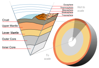
Scientific drilling into the Earth is a way for scientists to probe the Earth's sediments, crust, and upper mantle. In addition to rock samples, drilling technology can unearth samples of connate fluids and of the subsurface biosphere, mostly microbial life, preserved in drilled samples. Most of the technology used for drilling come from advances in the oil and gas industry. Scientific drilling is carried out on land by the International Continental Scientific Drilling Program (ICDP) and at sea by the Integrated Ocean Drilling Program (IODP). Scientific drilling on the continents includes drilling down into solid ground as well as drilling from small boats on lakes. Sampling thick glaciers and ice sheets to obtain ice cores is related but will not be described further here.

Chikyū (ちきゅう) is a Japanese scientific drilling ship built for the Integrated Ocean Drilling Program (IODP). The vessel is designed to ultimately drill 7 kilometres (4.3 mi) beneath the seabed, where the Earth's crust is much thinner, and into the Earth's mantle, deeper than any other hole drilled in the ocean thus far.

Uralmash is a heavy machine production facility of the Russian engineering corporation OMZ. The facility is located in Yekaterinburg, Russia, and is reported to employ around 16,500 people. The surrounding residential area where workers live is also called Uralmash.
Travelling to the Earth's center is a popular theme in science fiction. Some subterranean fiction involves traveling to the Earth's center and finding either a Hollow Earth or Earth's molten core. Planetary scientist David J. Stevenson suggested sending a probe to the core as a thought experiment. Humans have drilled over 12 kilometers in the Sakhalin-I. In terms of depth below the surface, the Kola Superdeep Borehole SG-3 retains the world record at 12,262 metres (40,230 ft) in 1989 and still is the deepest artificial point on Earth.
In the oil and gas industry, depth in a well is the measurement, for any point in that well, of the distance between a reference point or elevation, and that point. It is the most common method of reference for locations in the well, and therefore, in oil industry speech, "depth" also refers to the location itself.
The Lone Star Producing Company 1–27 Bertha Rogers hole or well was an oil-exploratory hole drilled in Washita County, Oklahoma in 1974, and was the world's deepest hole until it was surpassed in 1979 by the Kola Superdeep Borehole, dug by the USSR.

The Al Shaheen Oil Field is a production oil and gas field off the north east coast of Qatar in the Persian Gulf, 80 kilometres (50 mi) north of Doha. The oil field lies above the North Gas Field, one of the largest gas fields in the world. The field has been operated by Maersk Oil Qatar AS of Denmark until July 2017 under a production sharing agreement with Qatar Petroleum, on behalf of the state of Qatar. As of June 2016, Qatar Petroleum and the French major TotalEnergies established a new company known as "North Oil Company (Qatar)". The new company is 70% owned by Qatar Petroleum and 30% by TotalEnergies. North Oil Company took over field operations on 14 July 2017.

True vertical depth is the measurement of a straight line perpendicularly downwards from a horizontal plane.
Extended Reach Drilling (ERD) is directional drilling of very long horizontal wells. The aims of ERD are: a) to reach a larger area from one surface drilling location, and b) to keep a well in a reservoir for a longer distance in order to maximize its productivity and drainage capability.

Boring is drilling a hole, tunnel, or well in the Earth. It is used for various applications in geology, agriculture, hydrology, civil engineering, and mineral exploration. Today, most Earth drilling serves one of the following purposes:

The German Continental Deep Drilling Program, abbreviated as the KTB borehole, was a scientific drilling project carried out from 1987 to 1995 near Windischeschenbach, Bavaria. The main super-deep borehole reached a depth of 9,101 meters in the Earth's continental crust.

Deep horizontal drillhole disposal is the concept of disposing of high-level radioactive waste from a nuclear reactor in deep horizontal boreholes instead of in more traditional deep geological repositories that are excavated like mines. The design concept is intended to improve upon the vertical borehole concept developed by Sandia National Laboratories, by utilizing modern advancements in directional drilling technology as well as using isotopic methods to measure the affinity a host rock has for isolation.
