Mechelen-Bovelingen (French: Marlinne) is a village in the Belgian province Limburg and a deelgemeente (sub-municipality) of the municipality of Heers.
The former municipality Mechelen-Bovelingen consisted of the hamlets Mechelen, Bovelingen, and the now disappeared Pepingen. Because of increasing linear settlement, the hamlets of Mechelen and Bovelingen are no longer recognizable as separate entities.[1]
Former municipality
Until 1971 Mechelen-Bovelingen was a separate municipality with 1,300 inhabitants. From 1971 to 1977 it was a deelgemeente (sub-municipality) of Bovelingen together with Rukkelingen-Loon. In 1977 the short lived Bovelingen municipality became part of Heers municipality, to which the sub-municipality and village Mechelen-Bovelingen now belongs.
Nature and landscape
Mechelen-Bovelingen is on the plateau of Hesbaye, which locally has a height of 70 to 120m. The village is in the valley of the small Herk (river), which flows through it towards the north. The brook Grondelingenbeek exits into the Herk just north of the village, as do some other brooks.[1]
History
The Darishoeve in Mechelen-Bovelingen
In the Roman era there was at least one villa in the area. Remnants found were its foundations, pottery fragments and coins, the most recent from Marcus Aurelius (161-180). More foundations, fragments and coins were found elsewhere in the area. The Roman road from Tongeren over Heers to Gembloers crossed the surface of the former municipality.[1]
Mechelen-Bovelingen was first mentioned in the 12th century as 'Mechlen' and in a romanised form as 'Ma(r)lines'. From the 14th century it was often mentioned as 'Quaedmechelen'.[1] 'Quadt' means common, or small, and was used to distinguish it from the town of Mechelen.
Mechelen-Bovelingen was part of the personal domain of the Counts of Loon. It was divided into three lordships: Pepingen, Bovelingen and Mechelen and given to his vassals.[1]
Pepingen consisted of the southern part of the current Gelindenstraat and a part of the Kloosterstraat. Fastrad was the first known Lord of Pepingen. He died before 1332. In the 14th and 15th century Pepingen was held by the De Werfengeis family, followed by the Schroots family. Pepingen then came to Michel de Borchgrave by marriage.[1]
The Lordship Bovelingen was in the southern part of the former municipality. It was also known as Schalkhoven. Its first known lord was Jan van Schalkhoven, mentioned in 1390. Bovelingen was later held by the Van den Hoven family. In 1526 it was acquired by Aert Schroots Lord of Pepingen.[1]
In 1616 Michel de Borchgrave, who already held Pepingen, also bought Bovelingen. He probably lived at Bovelingen Castle and left Pepingen Castle. In 1619 Michel de Borchgrave also acquired Mechelen and Rukkelingen-Loon. The local branch of the family de Borchgrave d'Altena held on to these four lordships till the end of the Ancien Régime. In 1745 Johannes-Baptista de Borchgrave got the title Graaf van Altena (Count of Altena) from Elector of Bavaria.[1]
In 1795 the French authorities united the separate municipalities of Mechelen, Bovelingen and Pepingen into one municipality.[1]
Mechelen was the real village in the area, with the Saint Anne's church. The parish of Rukkelingen split off in 1213. Pepingen had Saint Martin's chapel, renovated in 1623 and 1673. When the domain of the castle expanded, Pepingen lost most of its inhabitants, and the chapel demolished in 1880.[1]
Mechelen-Bovelingen was a mainly agricultural village. In the village there was a now disappeared watermill. Along the road to Boekhout there was a windmill in the first half of the 19th century. Both were owned by the lords of the village / owners of the castle.[1]
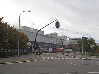
From 1872 till 1956 a râperie (suikerbietenmaalderij) of the Wanze Sugar Factory was operational in the village. Here the raw juice was extracted from sugar beet and then sent to the sugar factory in Wanze by pipeline. It employed about 40 people during the campaign, which generally ended in November or December.[2][1]
The village remained essentially rural with some large farms that still specialize in the culture of sugar beet. It lacked industrial activity, and so it developed into a commuter village.[1]
Demographics
Source:NIS, Note:1831 till 1961=volkstellingen
Sights
castle driveway
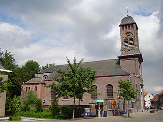
The Neo Gothic Saint Anne's church dates from c. 1910. It was built to a design by H. Martens from Stevoort and V. Lenertz from Leuven. It has some paintings and statues from the old church. The organ is also from the old church and has historic significance.[3]
The old cemetery on the Schoolstraat has a tombstone from 1539. The cemetery marks the location of the original Saint Anne's church. It stood on the cemetery with its entrance facing the parsonage. The church was demolished in 1913.[4]
Most of Bovelingen Castle on Altenastraat was destroyed by fire in 1947. What remains are the utility buildings from the late 19th and early 20th century, and the castle farm from the early 18th century. These buildings can be seen from the road, but cannot be visited. The castle driveway from Kloosterstraat to the castle is now a public walkway.[5]
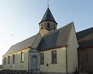
Saint-Martin's chapel on Kloosterstraat dates from 1872.[6]
Monument for the fallen on the crossing of Bovelingenstraat and Kloosterstraat.
Nearby
Rukkelingen-Loon
Batsheers
Gelinden
Boekhout
Related Research Articles
Koksijde is a town and a municipality in Belgium. It is located on the North Sea coast in the southwest of the Flemish province of West Flanders.
Sint-Pieters-Leeuw is a municipality in the province of Flemish Brabant, in the Flemish region of Belgium.
Perwez is a municipality of Wallonia located in the Belgian province of Walloon Brabant.
Raffinerie Tirlemontoise, a subsidiary of Raffinerie Tirlemontoise Group, is a Belgian sugar producing company. The company whose headquarters is located in Tienen (Belgium) has four business units: sugar activities, Orafti, Surafti and PPE, which together employ more than 1,800 people.
Elingen is a village in the municipality of Pepingen, in the Belgian province of Flemish Brabant. The parish church of St Amandus with its churchyard is registered as an element of the built heritage of Flanders.
Opbrakel is a village and deelgemeente (sub-municipality) of the municipality of Brakel. It is located in the Denderstreek in the province of East Flanders in Belgium. It used to be an independent municipality until 1971 when it was merged into Brakel.
Erwetegem is a village and deelgemeente (sub-municipality) belonging to the municipality of Zottegem. It is located in the Denderstreek and in the Flemish Ardennes, the hilly southern part of the province of East Flanders, Belgium. Erwetegem used to be an independent municipality until 1970.
Vinderhoute is a village in the municipality of Lievegem in the province of East Flanders in Belgium. It is located in the Flemish Valley about 6 kilometres (3.7 mi) north-west of Ghent.
Zevergem is a village and deelgemeente (sub-municipality) of De Pinte in East Flanders, Belgium. It is located on the Scheldt about 8 kilometres (5.0 mi) south of Ghent.
Verrebroek is a village and deelgemeente in the municipality of Beveren in East Flanders, Belgium. Verrebroek was an independent municipality until 1 January 1977, when it merged with Beveren as part of the fusion of municipalities in Belgium.
Groot-Bijgaarden is a village and deelgemeente in the municipality of Dilbeek, a suburb of Brussels, in Flanders, Belgium.
Schepdaal is a village and deelgemeente of Dilbeek in Flanders, Belgium.
Nieuwkerken-Waas is a village in the Belgian province East Flanders. Since 1977, it has been a subdivision (deelgemeente) of the municipality of Sint-Niklaas.
Liezele is a village and deelgemeente (sub-municipality) of the municipality of Puurs-Sint-Amands in the province of Antwerp, Belgium. The village is located about 20 kilometres (12 mi) south-south-west of the city of Antwerp. On the night of 4 to 5 September 1914, the entire village was destroyed by the Belgian Army to deny the Germany Army cover.
Rutten is a village in the Tongeren municipality of the Limburg province in the Flemish Community of Belgium. The village is located in the Haspengouw region, and was a separate municipality until its merger into Tongeren in 1977.
The Church of St. John the Baptist is a Roman Catholic parish church located in the centre of Molenbeek-Saint-Jean, a municipality of Brussels, Belgium. It is dedicated to Saint John the Baptist, the patron saint of Molenbeek.
Moha is a village and district of the municipality of Wanze, located in the province of Liège in Wallonia, Belgium.
Ouwegem is a village and deelgemeente (sub-municipality) in the municipality of Kruisem in the province of East Flanders in Belgium. The village is located on the edge of the Flemish Ardennes and about 17 kilometres (11 mi) south-west of Ghent.
The Wanze Sugar Factory was founded by the Sucreries Centrales SA. It is located in Wanze and is currently owned by Raffinerie Tirlemontoise. Wanze Sugar Factory is the only European sugar factory that still uses an outlying râperie connected by a pipeline. The râperie in Longchamps is located 23 km west of the central factory.
Longchamps is a village in the Belgian Namur Province and a deelgemeente (sub-municipality) of the municipality of Éghezée.
This page is based on this Wikipedia article Text is available under the CC BY-SA 4.0 license; additional terms may apply. Images, videos and audio are available under their respective licenses.