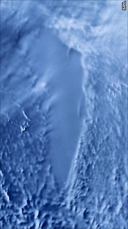
Lake Vostok is the largest of Antarctica's 675 known subglacial lakes. Lake Vostok is located at the southern Pole of Cold, beneath Russia's Vostok Station under the surface of the central East Antarctic Ice Sheet, which is at 3,488 m (11,444 ft) above mean sea level. The surface of this fresh water lake is approximately 4,000 m (13,100 ft) under the surface of the ice, which places it at approximately 500 m (1,600 ft) below sea level.

Signy Island is a small subantarctic island in the South Orkney Islands of Antarctica. It was named by the Norwegian whaler Petter Sørlle (1884–1933) after his wife, Signy Therese.
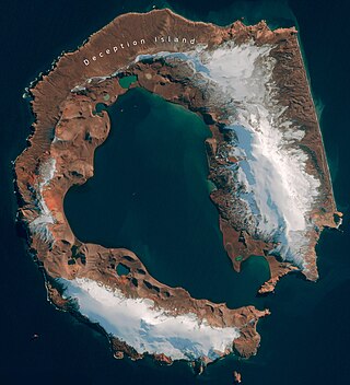
Deception Island is in the South Shetland Islands close to the Antarctic Peninsula with a large and usually "safe" natural harbor, which is occasionally affected by the underlying active volcano. This island is the caldera of an active volcano, which seriously damaged local scientific stations in 1967 and 1969. The island previously held a whaling station. It is now a tourist destination with over 15,000 visitors per year. Two research stations are operated by Argentina and Spain during the summer season. While various countries have asserted sovereignty, it is still administered under the Antarctic Treaty System.
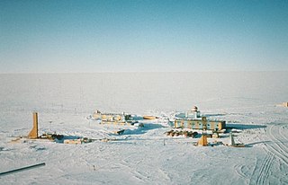
Vostok Station is a Russian research station in inland Princess Elizabeth Land, Antarctica. Founded by the Soviet Union in 1957, the station lies at the southern Pole of Cold, with the lowest reliably measured natural temperature on Earth of −89.2 °C. Research includes ice core drilling and magnetometry. Vostok was named after Vostok, the lead ship of the First Russian Antarctic Expedition captained by Fabian von Bellingshausen. The Bellingshausen Station was named after this captain.

Alexander Island, which is also known as Alexander I Island, Alexander I Land, Alexander Land, Alexander I Archipelago, and Zemlja Alexandra I, is the largest island of Antarctica. It lies in the Bellingshausen Sea west of Palmer Land, Antarctic Peninsula from which it is separated by Marguerite Bay and George VI Sound. The George VI Ice Shelf entirely fills George VI Sound and connects Alexander Island to Palmer Land. The island partly surrounds Wilkins Sound, which lies to its west. Alexander Island is about 390 kilometres (240 mi) long in a north–south direction, 80 kilometres (50 mi) wide in the north, and 240 kilometres (150 mi) wide in the south. Alexander Island is the second-largest uninhabited island in the world, after Devon Island.

Canada Glacier is a small glacier flowing south-east into the northern side of Taylor Valley in Victoria Land, Antarctica. It is in the Ross Dependency. Its melting season is in the summer.

Livingston Island is an Antarctic island in the Southern Ocean, part of the South Shetlands Archipelago, a group of Antarctic islands north of the Antarctic Peninsula. It was the first land discovered south of 60° south latitude in 1819, a historic event that marked the end of a centuries-long pursuit of the mythical Terra Australis Incognita and the beginning of the exploration and utilization of real Antarctica. The name Livingston, although of unknown derivation, has been well established in international usage since the early 1820s.
The Vestfold Hills are rounded, rocky, coastal hills, 512 square kilometres (198 sq mi) in extent, on the north side of Sorsdal Glacier on the Ingrid Christensen Coast of Princess Elizabeth Land, Antarctica. The hills are subdivided by three west-trending peninsulas bounded by narrow fjords. Most of the hills range between 30 and 90 metres in height, with the highest summit reaching nearly 160 metres (520 ft).

Jellyfish Lake is a marine lake located on Eil Malk island in Palau. Eil Malk is part of the Rock Islands, a group of small, rocky, mostly uninhabited islands in Palau's Southern Lagoon, between Koror and Peleliu. There are about 70 other marine lakes located throughout the Rock Islands. Millions of golden jellyfish migrate horizontally across the lake daily.

The Asgard Range is a mountain range in Victoria Land, Antarctica. It divides Wright Valley from Taylor Glacier and Taylor Valley. It is south of the Olympus Range and north of the Quartermain Mountains and the Kukri Hills.

The East Antarctic Ice Sheet (EAIS) lies between 45° west and 168° east longitudinally. It was first formed around 34 million years ago, and it is the largest ice sheet on the entire planet, with far greater volume than the Greenland ice sheet or the West Antarctic Ice Sheet (WAIS), from which it is separated by the Transantarctic Mountains. The ice sheet is around 2.2 km (1.4 mi) thick on average and is 4,897 m (16,066 ft) at its thickest point. It is also home to the geographic South Pole, South Magnetic Pole and the Amundsen–Scott South Pole Station.

Lake Untersee is the largest surface freshwater lake in the interior of the Gruber Mountains of central Queen Maud Land in East Antarctica. It is situated 90 kilometres (56 mi) to the southeast of the Schirmacher Oasis. The lake is approximately 6.5 kilometres (4.0 mi) long and 2.5 kilometres (1.6 mi) wide, with a surface area of 11.4 square kilometres (4.4 sq mi), and a maximum depth of 169 metres (554 ft). The lake is permanently covered with ice and is partly bounded by glacier ice.

The Schirmacher Oasis is a 25 km (16 mi) long and up to 3 km (1.9 mi) wide ice-free plateau with more than 100 freshwater lakes. It is situated in the Schirmacher Hills on the Princess Astrid Coast in Queen Maud Land in East Antarctica and is, on average, 100 m (330 ft) above sea level. With an area of 34 km2 (13 sq mi), the Schirmacher Oasis ranks among the smallest Antarctic oases and is a typical polar desert.

Antarctica is Earth's southernmost and least-populated continent. Situated almost entirely south of the Antarctic Circle and surrounded by the Southern Ocean, it contains the geographic South Pole. Antarctica is the fifth-largest continent, being about 40% larger than Europe, and has an area of 14,200,000 km2 (5,500,000 sq mi). Most of Antarctica is covered by the Antarctic ice sheet, with an average thickness of 1.9 km (1.2 mi).

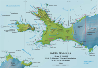
Byers Peninsula is a mainly ice-free peninsula forming the west end of Livingston Island in the South Shetland Islands of Antarctica. It occupies 60 km2 (23 sq mi), borders Ivanov Beach to the northeast and is separated from Rotch Dome on the east by the ridge of Urvich Wall. The peninsula features more than 60 meltwater streams and as many lakes, notably Midge Lake, Limnopolar Lake and Basalt Lake. Byers Peninsula has a regime of special environmental protection under the Antarctic Treaty System and requires a permit to enter.
Urvich Wall is the narrow ice-free and crescent-shaped ridge rising to 121 m on Livingston Island in the South Shetland Islands, Antarctica and bounded by Nedelya Point to the north and Rish Point to the southeast. The ridge is 6.7 km long and up to 400 m wide, and separates Byers Peninsula to the west from Rotch Dome to the east. It surmounts Oread Lake, Montemno Lake and Bedek Stream on the west.
On the continent of Antarctica, the Aramis Range is the third range south in the Prince Charles Mountains, situated 11 miles southeast of the Porthos Range and extending for about 30 miles in a southwest–northeast direction. It was first visited in January 1957 by Australian National Antarctic Research Expeditions (ANARE) southern party led by W.G. Bewsher, who named it for a character in Alexandre Dumas' novel The Three Musketeers, the most popular book read on the southern journey.

Dee Island is the ice-free island lying between Greenwich Island and Aitcho Islands in the South Shetland Islands, Antarctica and is separated from Greenwich Island to the south by the 850 m (930 yd) wide Orión Passage and from Aitcho Islands to the northeast by the 1.1 km (0.68 mi) wide Villalón Passage. Extending 1.9 by 1.37 km, with the conspicuous Burro Peaks in the southeast rising to 190 m (620 ft), and surface area 197 hectares. The small Montufar Island and Araguez Island are lying 650 m (710 yd) east of Dee Island and 200 m (220 yd) east of its southern tip Dragash Point respectively. The area was visited by 19th century sealers.
Juturna Lake is the roughly triangular lake extending 220 m in west-east direction and 150 m in north-south direction at the east extremity of South Beaches on Byers Peninsula, Livingston Island in the South Shetland Islands, Antarctica. Its surface area is 1.9 ha. The lake is separated from sea by a 40 to 57 m wide strip of land, and drains by way of a 260 m long stream flowing into the sea west of Rish Point. It is surmounted by Ritli Hill on the east. The area was visited by early 19th century sealers.

Mihaylovski Cove is the 5 km wide cove indenting for 1.3 km the northwest coast of South Bay in Livingston Island, Antarctica that is entered west of Ereby Point and east of Lukovo Point, and has its head fed by Kamchiya Glacier. The area was known to early 19th century sealers who operated from nearby Johnsons Dock. The feature is named after the brothers Petar Mihaylovski, physician at St. Kliment Ohridski base during the 2007/08 and subsequent seasons, and Hristo Mihaylovski, engineer in the national Antarctic campaign during 2015/16 and subsequent seasons.
