
Askham Bog is small area of peat bog and Site of Special Scientific Interest situated within the Vale of York in North Yorkshire, England. It lies to the south-west of York, north of Copmanthorpe and near Askham Richard and Askham Bryan. It is regarded as one of the most ecologically diverse sites in Northern England.

A savanna or savannah is a mixed woodland-grassland ecosystem characterised by the trees being sufficiently widely spaced so that the canopy does not close. The open canopy allows sufficient light to reach the ground to support an unbroken herbaceous layer consisting primarily of grasses. According to Britannica, there exists four savanna forms; savanna woodland where trees and shrubs form a light canopy, tree savanna with scattered trees and shrubs, shrub savanna with distributed shrubs, and grass savanna where trees and shrubs are mostly nonexistent.

A meadow is an open habitat or field, vegetated by grasses, herbs, and other non-woody plants. Trees or shrubs may sparsely populate meadows, as long as these areas maintain an open character. Meadows can occur naturally under favourable conditions, but are often artificially created from cleared shrub or woodland for the production of hay, fodder, or livestock. Meadow habitats, as a group, are characterized as "semi-natural grasslands", meaning that they are largely composed of species native to the region, with only limited human intervention.
Freshwater ecosystems are a subset of Earth's aquatic ecosystems. They include lakes, ponds, rivers, streams, springs, bogs, and wetlands. They can be contrasted with marine ecosystems, which have a larger salt content. Freshwater habitats can be classified by different factors, including temperature, light penetration, nutrients, and vegetation. There are three basic types of freshwater ecosystems: Lentic, lotic and wetlands. Freshwater ecosystems contain 41% of the world's known fish species.
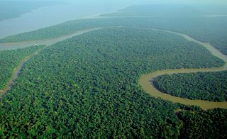
Tropical rainforests are rainforests that occur in areas of tropical rainforest climate in which there is no dry season – all months have an average precipitation of at least 60 mm – and may also be referred to as lowland equatorial evergreen rainforest. True rainforests are typically found between 10 degrees north and south of the equator ; they are a sub-set of the tropical forest biome that occurs roughly within the 28-degree latitudes. Within the World Wildlife Fund's biome classification, tropical rainforests are a type of tropical moist broadleaf forest that also includes the more extensive seasonal tropical forests.

Vernal pools, also called vernal ponds or ephemeral pools, are seasonal pools of water that provide habitat for distinctive plants and animals. They are considered to be a distinctive type of wetland usually devoid of fish, and thus allow the safe development of natal amphibian and insect species unable to withstand competition or predation by fish. Certain tropical fish lineages have however adapted to this habitat specifically.
In biology, a refugium is a location which supports an isolated or relict population of a once more widespread species. This isolation (allopatry) can be due to climatic changes, geography, or human activities such as deforestation and overhunting.

In ecology, a disturbance is a temporary change in environmental conditions that causes a pronounced change in an ecosystem. Disturbances often act quickly and with great effect, to alter the physical structure or arrangement of biotic and abiotic elements. A disturbance can also occur over a long period of time and can impact the biodiversity within an ecosystem.

Round Island is an uninhabited islet 22.5 kilometres north of Mauritius. It has an area of 1.69 square kilometres and a maximum elevation of 280 metres. The island has been a nature reserve since 1957 and is administered jointly by the National Parks and Conservation Service and the Mauritian Wildlife Foundation. The island has been designated an Important Bird Area (IBA) by BirdLife International.

The southern toad is a true toad native to the southeastern United States, from eastern Louisiana and southeastern Virginia south to Florida. It often lives in areas with sandy soils. It is nocturnal and spends the day in a burrow. Its coloring is usually brown but can be red, gray, or black. It is approximately 8 cm (3 inches) long.

Clianthus puniceus, common name kaka beak, is a species of flowering plant in the genus Clianthus of the legume family Fabaceae, native to New Zealand's North Island.

The Metacomet-Monadnock Trail is a 114-mile-long (183 km) hiking trail that traverses the Metacomet Ridge of the Pioneer Valley region of Massachusetts and the central uplands of Massachusetts and southern New Hampshire. Although less than 70 miles (110 km) from Boston and other large population centers, the trail is considered remarkably rural and scenic and includes many areas of unique ecologic, historic, and geologic interest. Notable features include waterfalls, dramatic cliff faces, exposed mountain summits, woodlands, swamps, lakes, river floodplain, farmland, significant historic sites, and the summits of Mount Monadnock, Mount Tom and Mount Holyoke. The Metacomet-Monadnock Trail is maintained largely through the efforts of the Berkshire Chapter of the Appalachian Mountain Club (AMC). Much of the trail is a portion of the New England National Scenic Trail.
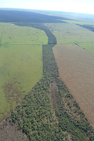
A wildlife corridor, habitat corridor, or green corridor is an area of habitat connecting wildlife populations separated by human activities or structures. This allows an exchange of individuals between populations, which may help prevent the negative effects of inbreeding and reduced genetic diversity that often occur within isolated populations. Corridors may also help facilitate the re-establishment of populations that have been reduced or eliminated due to random events. This may potentially moderate some of the worst effects of habitat fragmentation, wherein urbanization can split up habitat areas, causing animals to lose both their natural habitat and the ability to move between regions to access resources. Habitat fragmentation due to human development is an ever-increasing threat to biodiversity, and habitat corridors serve to manage its effects.
Westmeath Provincial Park is a provincial park on the Ottawa River in Renfrew County, Ontario, Canada. Located on the section of the river known as Bellows Bay, it features a long sandy beach and an active sandspit. It is one of the most pristine sand dune and wetland complexes along the southern Ottawa River.

Kunzea ericifolia, commonly known as spearwood, native tree or yellow kunzea, or as kitja boorn, poorndil or condil by the Noongar people, is an erect woody evergreen shrub that is endemic to Western Australia. It has soft green linear leaves and spherical heads of usually yellow flowers in spring.

A pond is a small, still, land-based body of water formed by pooling inside a depression, either naturally or artificially. A pond is smaller than a lake and there are no official criteria distinguishing the two, although defining a pond to be less than 5 hectares in area, less than 5 metres (16 ft) in depth and with less than 30% with emergent vegetation helps in distinguishing the ecology of ponds from those of lakes and wetlands. Ponds can be created by a wide variety of natural processes, or they can simply be isolated depressions filled by runoff, groundwater, or precipitation, or all three of these. They can be further divided into four zones: vegetation zone, open water, bottom mud and surface film. The size and depth of ponds often varies greatly with the time of year; many ponds are produced by spring flooding from rivers. Ponds may be freshwater or brackish in nature. 'Ponds' with saltwater, with a direct connection to the sea that maintains full salinity, would normally be regarded as part of the marine environment because they would not support fresh or brackish water organisms, so not really within the realm of freshwater science.
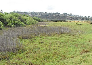
Brackish marshes develop from salt marshes where a significant freshwater influx dilutes the seawater to brackish levels of salinity. This commonly happens upstream from salt marshes by estuaries of coastal rivers or near the mouths of coastal rivers with heavy freshwater discharges in the conditions of low tidal ranges.
The wildlife of Chile is very diverse because of the country's slender and elongated shape, which spans a wide range of latitude, and altitude, ranging from the windswept coastline of the Pacific coast on the west to northern Andes to the sub-Antarctic, high Andes mountains in the east. There are many distinct ecosystems.

The Banyang-Mbo Wildlife Sanctuary is a wildlife sanctuary found in Cameroon. It was established in 1996. This site is 691.45 km2.

Victoria Forest Park, is situated on the West Coast of the South Island of New Zealand. At 2,069 square kilometres (799 sq mi) it is New Zealand's largest forest park. The park is administered by the Department of Conservation (DOC).
