
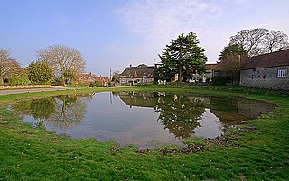
Fontmell Magna is a village and civil parish in Dorset, England. It is situated in the Blackmore Vale, close to the chalk hills of Cranborne Chase, on the A350 road five miles south of Shaftesbury and eight miles north of Blandford Forum. In the 2011 census the parish had a population of 734.
Cranborne Chase is an area of central southern England, straddling the counties Dorset, Hampshire and Wiltshire. It is part of the Cranborne Chase and West Wiltshire Downs Area of Outstanding Natural Beauty (AONB).

Lardon Chase, the Holies and Lough Down is a National Trust countryside property in the English county of Berkshire. It is situated on the edge of the Berkshire Downs above the village of Streatley and overlooking the Goring Gap. The property comprises an outstanding area of 27 hectares of downland and woodland with many attractive walks and views. Lardon Chase, and a part of the Holies known as Holies Down, are also designated as Sites of Special Scientific Interest. The property lies within the North Wessex Downs Area of Outstanding Natural Beauty, and in an area known for the presence of several Neolithic and Iron Age forts.

The Lulworth skipper is a butterfly of the family Hesperiidae. Its name is derived from Lulworth Cove in the county of Dorset, England, where the first specimens in Great Britain were collected in 1832 by English naturalist James Charles Dale.
Sixpenny Handley Hundred was a hundred in the county of Dorset, England. It originally consisted of two distinct hundreds: Sexpena and Hanlega. Sometime around the 14th century, the two hundreds were united as the hundred of "Sexpenne et Henle". Sixpenny Handley Hundred contained the following parishes:

Old Winchester Hill is a 66.2-hectare (164-acre) biological Site of Special Scientific Interest in Hampshire. It is a Nature Conservation Review site, Grade I, and a national nature reserve. Part of it is a scheduled monument.

Burham Down is a 110-hectare (270-acre) nature reserve between Maidstone and Chatham in Kent. It is managed by the Kent Wildlife Trust. It is part of the Wouldham to Detling Escarpment Site of Special Scientific Interest and Nature Conservation Review site, Grade I, the Kent Downs Area of Outstanding Natural Beauty, and the North Downs Woodlands Special Area of Conservation.

Lydden and Temple Ewell Downs is a 63.2-hectare (156-acre) biological Site of Special Scientific Interest north-west of Dover in Kent. It is a Special Area of Conservation and Nature Conservation Review site. It is also part of the 78.5-hectare (194-acre) Lydden Temple Ewell National Nature Reserve and the 90-hectare (220-acre) Lydden Temple Ewell nature reserve, which is managed by the Kent Wildlife Trust. It is in the North Downs Area of Outstanding Natural Beauty.

Hackhurst and White Downs is a 185.1-hectare (457-acre) biological Site of Special Scientific Interest west of Dorking in Surrey. White Downs is a Nature Conservation Review site, Grade 2, and part of it is in the 200-hectare (490-acre) White Downs nature reserve, which is owned by the Wotton Estate and managed by the Surrey Wildlife Trust (SWT). Hackhurst Downs is a 29.9-hectare (74-acre) Local Nature Reserve, which part of the 40-hectare (99-acre) Hackhurst Downs nature reserve, which is owned by Surrey County Council and also managed by the SWT.

Clayton to Offham Escarpment is a 422.5-hectare (1,044-acre) linear biological Site of Special Scientific Interest (SSSI) which runs from Clayton in West Sussex to Lewes in East Sussex. Its ownership and management is divided between over fifteen landowners and farmers. Parts of Ditchling's Downs, e.g. TQ 323 133, and the scarp between Blackcap and Mount Harry, e.g. TQ 378 124, are owned by the National Trust. What remains of Ditchling Tenantry Down common at Ditchling Beacon is leased to the Sussex Wildlife Trust.

Aston Rowant National Nature Reserve is located on the north-west escarpment of the Chiltern Hills, in the Chilterns Area of Outstanding Natural Beauty. It has an area of 159.1 hectares, and most of it is a 128.5 hectares biological Site of Special Scientific Interest. It is listed as a Grade 1 site in A Nature Conservation Review. The reserve is in several sections, mostly in the parish of Lewknor in Oxfordshire, with smaller sections in the parish of Stokenchurch in Buckinghamshire.
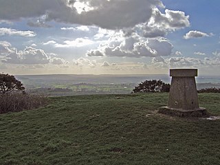
Melbury Hill, whose summit is also called Melbury Beacon, is a prominent hill, 263 metres high, on the high chalk escarpment of the North Dorset Downs above the village of Melbury Abbas in the county of Dorset in southern England.

The Blackmoor Vale and Vale of Wardour area is a natural region in the counties of Dorset, Somerset and Wiltshire in southern England.

Perryfield Quarry is an operational stone quarry and part butterfly nature reserve located on the Isle of Portland, Dorset, England. It is situated towards the middle of the island, east of the village of Weston and south of the hamlet of Wakeham. The reserve section is now a valued home for a number of butterfly species, while the working quarry area is one of the largest active quarries on Portland. The quarry is owned by Portland Stone Firms Ltd, along with Broadcroft and Coombefield Quarries. The firm is the largest landholder on the island.

Bevendean Down is a 64.6-hectare (160-acre) Local Nature Reserve in the Bevendean district in Brighton, East Sussex and is within the boundaries of the South Downs National Park. It is owned by Brighton and Hove Council and managed by tenant farmers and others. It is mainly chalk grassland and there are also areas of woodland and scrub. This site is in five separate blocks.

Beeding Hill to Newtimber Hill is a 321 ha (790-acre) biological and geological Downland Site of Special Scientific Interest (SSSI) north of Shoreham-by-Sea in West Sussex. It is a Nature Conservation Review site, Grade 2, and it includes Devil's Dyke Geological Conservation Review site.

Swyncombe Downs is a 47.1-hectare (116-acre) biological Site of Special Scientific Interest east of Wallingford in Oxfordshire.

Broughton Down is a 45.8-hectare (113-acre) biological Site of Special Scientific Interest west of Broughton in Hampshire. The eastern half is a nature reserve managed by the Hampshire and Isle of Wight Wildlife Trust.

Martin and Tidpit Downs is a 367.5-hectare (908-acre) biological Site of Special Scientific Interest north-west of Fordingbridge in Hampshire. Martin Down is a 341-hectare (840-acre) national nature reserve and an area of 115 hectares is a Nature Conservation Review site, Grade I. Bokerley Dyke, a prehistoric linear earthwork and scheduled monument, runs through the site.
