Bali is a province of Indonesia and the westernmost of the Lesser Sunda Islands. East of Java and west of Lombok, the province includes the island of Bali and a few smaller offshore islands, notably Nusa Penida, Nusa Lembongan, and Nusa Ceningan to the southeast. The provincial capital, Denpasar, is the most populous city in the Lesser Sunda Islands and the second-largest, after Makassar, in Eastern Indonesia. The upland town of Ubud in Greater Denpasar is considered Bali's cultural centre. The province is Indonesia's main tourist destination, with a significant rise in tourism since the 1980s. Tourism-related business makes up 80% of its economy.

Lombok is an island in West Nusa Tenggara province, Indonesia. It forms part of the chain of the Lesser Sunda Islands, with the Lombok Strait separating it from Bali to the west and the Alas Strait between it and Sumbawa to the east. It is roughly circular, with a "tail" to the southwest, about 70 kilometres across and a total area of about 4,738.65 square kilometres including smaller offshore islands. The provincial capital and largest city on the island is Mataram.

Sumbawa is an Indonesian island, located in the middle of the Lesser Sunda Islands chain, with Lombok to the west, Flores to the east, and Sumba further to the southeast. Along with Lombok, it forms the province of West Nusa Tenggara, but there have been plans by the Indonesian government to split the island off into a separate province. Traditionally, the island is known as the source of sappanwood, as well as honey and sandalwood. Its savanna-like climate and vast grasslands are used to breed horses and cattle, as well as to hunt deer.
Java is one of the Greater Sunda Islands in Indonesia. It is bordered by the Indian Ocean to the south and the Java Sea to the north. With a population of 151.6 million people, Java is the world's most populous island, home to approximately 56% of the Indonesian population.

East Java is a province of Indonesia located in the easternmost third of Java island. It has a land border only with the province of Central Java to the west; the Java Sea and the Indian Ocean border its northern and southern coasts, respectively, while the narrow Bali Strait to the east separates Java from Bali by around 2.29 kilometres (1.42 mi). Located in eastern Java, the province also includes the island of Madura, as well as the Kangean islands and other smaller island groups located further east and Masalembu archipelagos in the north. Its capital is Surabaya, the second largest city in Indonesia, a major industrial center and also a major business center. Banyuwangi is the largest regency in East Java and the largest on the island of Java.

West Nusa Tenggara is a province of Indonesia. It comprises the western portion of the Lesser Sunda Islands, with the exception of Bali which is its own province. Mataram, on Lombok, is the capital and largest city of the province. It shares maritime borders with Bali to the west and East Nusa Tenggara to the east. The 2010 census recorded the population at 4,500,212; the total rose to 4,830,118 at the 2015 Intermediate Census and 5,320,092 at the 2020 census; the official estimate as at mid 2022 was 5,473,671. The province's area is 20,153.15 km2. The two largest islands by far in the province are Lombok in the west and the larger Sumbawa island in the east.

Banyuwangi Regency is a regency of East Java province in Indonesia. This regency also known as the sun rise of Java because it is located at the easternmost end of Java Island. The town of Banyuwangi serves as a port for ferry services between Java and Bali. The regency is surrounded by mountains and forests to the west; by sea to the east and south - is separated by the Strait of Bali from Bali. With an area of 5,782.4 km2, this regency is the largest on the island of Java. The regency is a tourist destination, and subject to ongoing development as an international tourist destination with relevant infrastructure. Banyuwangi regency has been declared a taman bumi, or national geological park (Geopark) in 2018.

Baluran National Park is located in Situbondo Regency, East Java, Indonesia. It has a relatively dry climate and mainly consists of savanna (40%), as well as lowland forests, mangrove forests and hills, with Mount Baluran (1,247m) as its highest peak.

Tourism in Indonesia is an important component of the Indonesian economy as well as a significant source of its foreign exchange revenues. Indonesia was ranked at 20th in the world tourist Industry in 2017, also ranked as the ninth-fastest growing tourist sector in the world, the third-fastest growing in Asia and fastest-growing in Southeast Asia. In 2018, Denpasar, Jakarta and Batam are among of 10 cities in the world with fastest growth in tourism, 32.7, 29.2 and 23.3 percent respectively. The tourism sector ranked as the 4th largest among goods and services export sectors.

The Osing or Using are indigenous ethnic group native to easternmost part of the Java island, Indonesia. They are the descendants of the people of the ancient Kingdom of Blambangan. The population of Osing people are approximately 400,000 which concentrated in the Banyuwangi Regency of East Java Province.

Buleleng is a regency of Bali Province, Indonesia. It stretches along the north side of the island of Bali from the Bali Strait in the west almost to the eastern end of the island. It has an area of 1,365.88 km2 and population of 624,125 at the 2010 census and 791,910 at the 2020 census; the official estimate as at mid 2022 was 825,141. Its regency seat is at the town of Singaraja.

West Bali National Park is a national park located in Buleleng Regency, Bali, Indonesia. The park covers around 190 square kilometres (73 sq mi), of which are 158 square kilometres (61 sq mi) land and the remainder is sea. This is approximately 3% of Bali's total land area. To the north, it includes a 1,000-metre (3,300 ft) long beach, reef and islets. A seaport at Gilimanuk is west of the park, and the village of Goris is to the east. The National Park can be reached by roads from Gilimanuk and Singaraja, or by using ferries from Ketapang, East Java.
This is an article about the extreme points of Indonesia.

The following outline is provided as an overview of and topical guide to Indonesia:

West Lombok Regency is a regency of the Indonesian Province of West Nusa Tenggara. It is located on the island of Lombok and the administrative capital is the town of Gerung. The regency covers an area of 922.91 km2 and had a population of 599,609 at the 2010 census and 721,481 at the 2020 census; the official estimate as at mid 2021 was 744,309.

East Lombok Regency is a regency of the Indonesian Province of West Nusa Tenggara. It is located on the island of Lombok, of which it comprises the eastern third ; the administrative capital is the town of Selong. The Regency covers an area of 1,605.55 km2 and had a population of 1,105,582 at the 2010 Census and 1,325,240 at the 2020 Census; the official estimate as at mid 2022 was 1,366,434.

Central Lombok Regency is a regency of the Indonesian Province of West Nusa Tenggara. It is located on the island of Lombok and the capital is Praya. It covers an area of 1,208.39 km2, and had a population of 859,309 at the 2010 census and 1,034,859 at the 2020 census; the official estimate as at mid 2022 was 1,067,682.

Banyuwangi, previously known as Banjoewangi, is the administrative capital of Banyuwangi Regency at the far eastern end of the island of Java, Indonesia. It had a population of 106,000 at the 2010 census and 117,558 at the 2020 census.

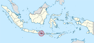
The eastern salient of Java is a region that makes up the easternmost part of the island of Java, Indonesia. It is not a formal or administrative subdivision, but rather a designation often used to refer to its distinct history, culture, and geographical feature. It is generally considered to begin in the Tengger mountain range and extend eastwards to the east coast of Java. It is entirely contained by the Indonesian province of East Java.


