
The West End of London is a district of Central London, London, England, west of the City of London and north of the River Thames, in which many of the city's major tourist attractions, shops, businesses, government buildings and entertainment venues, including West End theatres, are concentrated.

Covent Garden is a district in London, on the eastern fringes of the West End, between St Martin's Lane and Drury Lane. It is associated with the former fruit-and-vegetable market in the central square, now a popular shopping and tourist site, and with the Royal Opera House, itself known as "Covent Garden". The district is divided by the main thoroughfare of Long Acre, north of which is given over to independent shops centred on Neal's Yard and Seven Dials, while the south contains the central square with its street performers and most of the historical buildings, theatres and entertainment facilities, including the London Transport Museum and the Theatre Royal, Drury Lane.

Shaftesbury Avenue is a major road in the West End of London, named after The 7th Earl of Shaftesbury. It runs north-easterly from Piccadilly Circus to New Oxford Street, crossing Charing Cross Road at Cambridge Circus. From Piccadilly Circus to Cambridge Circus, it is in the City of Westminster, and from Cambridge Circus to New Oxford Street, it is in the London Borough of Camden.

Seven Dials is a road junction and neighbourhood in the St Giles district of the London Borough of Camden, within the greater Covent Garden area in the West End of London. Seven streets of the Seven Dials area converge at the roughly circular central roundabout, at the centre of which is a column bearing six sundials – with the column itself acting as the seventh sundial.

Long Acre is a street in the City of Westminster in central London. It runs from St Martin's Lane, at its western end, to Drury Lane in the east. The street was completed in the early 17th century and was once known for its coach-makers, and later for its car dealers.
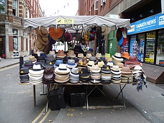
Earlham Street Market is a street market in situated in the Seven Dials area of Covent Garden on a short road between Shaftesbury Avenue and Monmouth Street. Licences to trade are issued by Camden London Borough Council.

The Phoenix Garden is a local community garden in central London, England, established in 1984. Located in St Giles behind the Phoenix Theatre, within the London Borough of Camden, the Phoenix Garden is nestled between the busy Soho and Covent Garden areas. The Garden is located just off St Giles Passage and Stacey Street, north of Shaftesbury Avenue and east of Charing Cross Road.

Freed of London Ltd, often referred to simply as Freed, is a designer and manufacturer of pointe shoes and other dance shoes. The company additionally manufactures dance apparel, bridal, and fashion collections. Freed of London shoes are handcrafted in the UK and today the brand is available in over 50 countries. While Freed began in a basement in Covent Garden, it now comprises nine retail stores, seven offices, five warehouses, and three manufacturing sites.
Shaftesbury PLC was a British real estate investment trust which invests exclusively in the heart of London's West End. It was headquartered in London and was listed on the London Stock Exchange until it merged with Capital & Counties Properties to form Shaftesbury Capital in March 2023.
Shaftesbury Capital, formerly Capital & Counties Properties plc, (Capco) is a United Kingdom-based property investment and development company focused on sites in the West End of London, including Covent Garden, Chinatown London and Carnaby Street, Soho.
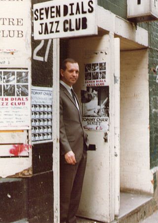
The Seven Dials Jazz Club opened its doors in 1980 as a venue for live music in Covent Garden, London. It hosted a range of artists and styles of jazz and began to attract a regular audience. Starting in 1983, a series of saxophone festivals was held on the premises each year.

The Bedford Estate is an estate in central London owned by the Russell family, which holds the peerage title of Duke of Bedford. The estate was originally based in Covent Garden, then stretched to include Bloomsbury in 1669. The Covent Garden property was sold for £2 million in 1913 by Herbrand Russell, 11th Duke of Bedford, to the MP and land speculator Harry Mallaby-Deeley, who sold his option to the Beecham family for £250,000; the sale was finalised in 1918.
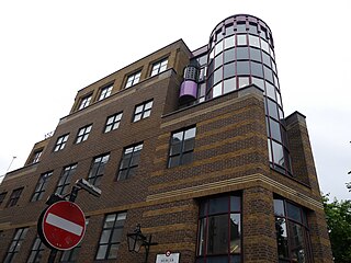
Comyn Ching Triangle is a triangular city block at the Seven Dials junction in Covent Garden, London. It is bounded by Monmouth, Mercer and Shelton Streets, and comprises a perimeter of terraced buildings surrounding Ching Court, a public space. A 1980s regeneration of the block by the architecture firm Terry Farrell and Partners is considered an exemplar of British postmodern architecture.
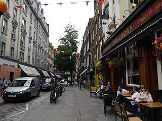
Monmouth Street is a street in the Seven Dials district of Covent Garden, London, England.

The Crown is a pub in Covent Garden, London, at 43 Monmouth Street facing on to Seven Dials and Short's Gardens.
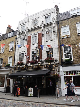
The Two Brewers is a pub in Covent Garden, London, at 40 Monmouth Street.

Earlham Street is a street in Covent Garden, in the London Borough of Camden that runs from Shaftesbury Avenue in the west to Neal Street in the east, crossing Seven Dials midway, where it intersects with Monmouth Street, Mercer Street, and Shorts Gardens. Tower Street and Tower Court join it on its south side.
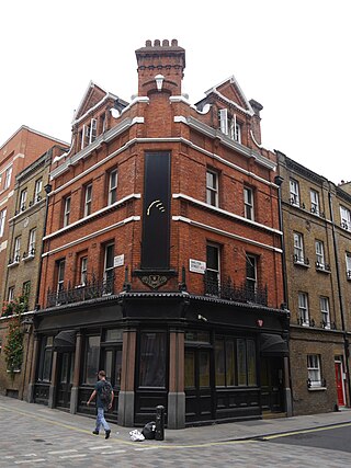
The Mercers' Arms was a pub at 17 Mercer Street, in London's Covent Garden, at the corner with Shelton Street. It closed as a pub in about 1973, and is now a private dining club.
This is a list of the etymology of street names in the London district of Covent Garden. Covent Garden has no formally defined boundaries – those utilised here are: Shaftesbury Avenue to the north-west, New Oxford Street and High Holborn to the north, Kingsway and the western half of the Aldwych semi-circle to the east, Strand to the south and Charing Cross Road to the west.


