Long Acre

Last updated

Long Acre pictured in 1991 Covent Garden Underground station geograph-3322707-by-Ben-Brooksbank.jpg
Long Acre pictured in 1991

Long Acre is a street in the City of Westminster in central London. It runs from St Martin's Lane, at its western end, to Drury Lane in the east. The street was completed in the early 17th century and was once known for its coach-makers, and later for its car dealers.

Contents

History

After the dissolution of the Monasteries in 1540, Henry VIII confiscated the land belonging to Westminster Abbey, including the convent garden of Covent Garden and land to the north originally called the Elms and later Seven Acres. [1] In 1552, his son, Edward VI, granted it to John Russell, 1st Earl of Bedford. [2] The Russell family, who in 1694 were advanced in their peerage from Earl to Duke of Bedford, held the land from 1552 to 1918. [3]

At the time of Charles I it was renamed Long Acre after the length of the first pathway constructed across the land. [1] Charles took offence at the condition of the road and houses along it, which were the responsibility of Russell and Henry Carey, 2nd Earl of Monmouth. Russell and Carey complained that under the 1625 Proclamation concerning Buildings, which restricted building in and around London, they could not build new houses; the King then granted Russell, for a fee of £2,000, a licence to build as many new houses on his land as he "shall thinke fitt and convenient". [4] This licence allowed the development of Covent Garden Square to the south of Long Acre.

Austin Motors showroom, at 134 Long Acre, circa 1910 Thinktank Birmingham - Austin(4).jpg
Austin Motors showroom, at 134 Long Acre, circa 1910

The coach-building trade dominated Long Acre in the 19th century – in 1906, 41 buildings in the street were occupied by firms associated with transport, a mixture of traditional coach-builders and those connected with the motor trade. By 1916 the transition to motor cars and related trades was almost complete. [5] The Austin Motors showroom was at 134, and Mercedes-Benz's at No. 127–130, close to Daimler and Fiat.

The section on the north side from Neal Street to Arne Street was occupied by Odhams Press from about 1890 to 1970. It published John Bull, which was the most popular magazine in Britain from 1916 to 1934. Odhams also published The Daily Herald, Woman's Own , Debrett's and Sporting Life (founded 1859). Odhams was bought by the International Publishing Corporation in 1961 and the site was closed down in 1969. Prior to Odhams, the site was occupied by the Queen's Theatre (1867–1878), the second-largest theatre in London at the time, after Drury Lane. It was here that Ellen Terry first met Henry Irving in a Shakespearean role. There is a plaque to commemorate the theatre, but it has been placed on the wrong block[ citation needed ] — the theatre was to the east of Endell Street, not the west. On Acre House (No. 69–75) is a green plaque commemorating Denis Johnson's workshop. [6] He lived c. 1760 to 1833 and had a workshop here in 1819, selling "hobby horse" bicycles, the first to be sold in the United Kingdom. Emma Martin, author, socialist and free thinker worked as a midwife from No.100 where her daughters ran a surgical bandage shop. [7]

At No. 132, John Logie Baird made the first British television broadcast in 1929. Just off Long Acre is Langley Street, home of the Pineapple Dance Studios and London Film School, the oldest such school in the world. Just opposite, until 2000, was Paxman, one of the leading English manufacturers of French horns. It is said that the poet Richard Lovelace spent his final years in Long Acre, in great poverty. As a young man, Thomas Paine worked as a corset maker in Long Acre. In 1896, the Freemason's Arms was built; it still stands on Long Acre. Masonic symbols adorn the façade.

Freemasons' Hall at the eastern end of Long Acre Freemasons' Hall from Long Acre.jpg
Freemasons' Hall at the eastern end of Long Acre

Geography

Long Acre is numbered 1 to 77 on the south side and 78 to 144 on the north side. At the junction with James Street is Covent Garden Underground station.

Long Acre ends in the east at a junction with Drury Lane. Overlooking this junction is Freemasons' Hall, the headquarters of the British Freemasons, on Great Queen Street.

Long Acre is numbered B402 in the British road numbering scheme.

Related Research Articles

<span class="mw-page-title-main">West End of London</span> Area of Central London, England

The West End of London is a district of Central London, London, England, west of the City of London and north of the River Thames, in which many of the city's major tourist attractions, shops, businesses, government buildings and entertainment venues, including West End theatres, are concentrated.

<span class="mw-page-title-main">Covent Garden</span> District in London, England

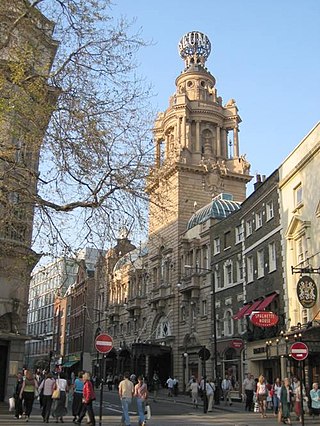
Covent Garden is a district in London, on the eastern fringes of the West End, between St Martin's Lane and Drury Lane. It is associated with the former fruit-and-vegetable market in the central square, now a popular shopping and tourist site, and with the Royal Opera House, itself known as "Covent Garden". The district is divided by the main thoroughfare of Long Acre, north of which is given over to independent shops centred on Neal's Yard and Seven Dials, while the south contains the central square with its street performers and most of the historical buildings, theatres and entertainment facilities, including the London Transport Museum and the Theatre Royal, Drury Lane.

<span class="mw-page-title-main">Thomas Arne</span> 18th-century British composer

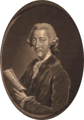
Thomas Augustine Arne was an English composer. He is best known for his patriotic song "Rule, Britannia!" and the song "A-Hunting We Will Go", the latter composed for a 1777 production of The Beggar's Opera, which has since become popular as a folk song and a nursery rhyme. Arne was a leading British theatre composer of the 18th century, working at the West End's Drury Lane and Covent Garden. He wrote many operatic entertainments for the London theatres and pleasure gardens, as well as concertos, sinfonias, and sonatas.

<span class="mw-page-title-main">Drury Lane</span> Street in central London, England

Drury Lane is a street on the eastern boundary of the Covent Garden area of London, running between Aldwych and High Holborn. The northern part is in the borough of Camden and the southern part in the City of Westminster. Drury Lane is part of London's West End Theatreland.

<span class="mw-page-title-main">Royal Opera House</span> Performing arts venue in London, England

The Royal Opera House (ROH) is a historic opera house and major performing arts venue in Covent Garden, central London. The large building is often referred to as simply Covent Garden, after a previous use of the site. It is the home of The Royal Opera, The Royal Ballet, and the Orchestra of the Royal Opera House. The first theatre on the site, the Theatre Royal (1732), served primarily as a playhouse for the first hundred years of its history. In 1734, the first ballet was presented. A year later, the first season of operas, by George Frideric Handel, began. Many of his operas and oratorios were specifically written for Covent Garden and had their premieres there.

<span class="mw-page-title-main">Francis Russell, 4th Earl of Bedford</span> English nobleman and politician

Francis Russell, 4th Earl of Bedford PC was an English nobleman and politician. He built the square of Covent Garden, with the piazza and church of St. Paul's, employing Inigo Jones as his architect. He is also known for his pioneering project to drain The Fens of Cambridgeshire.

<span class="mw-page-title-main">Bow Street</span> Street in London, England

Bow Street is a thoroughfare in Covent Garden, Westminster, London. It connects Long Acre, Russell Street and Wellington Street, and is part of a route from St Giles to Waterloo Bridge.

<span class="mw-page-title-main">Henry Holland (architect)</span> English architect

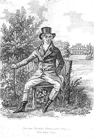
Henry Holland was an architect to the English nobility.

<span class="mw-page-title-main">Fortune Theatre</span> West End theatre in London, England

The Fortune Theatre is a 432-seat West End theatre on Russell Street, near Covent Garden, in the City of Westminster. From 1989 until 2023 the theatre hosted the long running play The Woman in Black.

<span class="mw-page-title-main">St Martin's Lane</span> Street in the City of Westminster, London

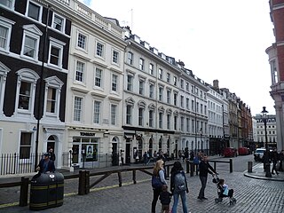
St Martin's Lane is a street in the City of Westminster, which runs from the church of St Martin-in-the-Fields, after which it is named, near Trafalgar Square northwards to Long Acre. At its northern end, it becomes Monmouth Street. St Martin's Lane and Monmouth Street together form the B404.

<span class="mw-page-title-main">Great Queen Street</span> Street in London, England

Great Queen Street is a street in the West End of central London in England. It is a continuation of Long Acre from Drury Lane to Kingsway. It runs from 1 to 44 along the north side, east to west, and 45 to about 80 along the south side, west to east. The street straddles and connects the Covent Garden and Holborn districts and is in the London Borough of Camden. It is numbered B402.

<span class="mw-page-title-main">St Paul's, Covent Garden</span> Church in London, England

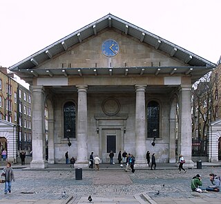
St Paul's Church is a Church of England parish church located in Bedford Street, Covent Garden, central London. It was designed by Inigo Jones as part of a commission for the 4th Earl of Bedford in 1631 to create "houses and buildings fit for the habitations of Gentlemen and men of ability". As well as being the parish church of Covent Garden, the church has gained the nickname of "the actors' church" by a long association with the theatre community.

<span class="mw-page-title-main">Clare Market</span> Historic area in London, England

Clare Market is a historic area in central London located within the parish of St Clement Danes to the west of Lincoln's Inn Fields, between the Strand and Drury Lane, with Vere Street adjoining its western side. It was named after the food market which had been established in Clement's Inn Fields, by John Holles, 2nd Earl of Clare. Much of the area and its landmarks were immortalised by Charles Dickens in The Old Curiosity Shop, The Pickwick Papers, Barnaby Rudge and Sketches by Boz.

<span class="mw-page-title-main">Holborn and Covent Garden (ward)</span> Electoral ward in England

Holborn and Covent Garden is a ward of the London borough of Camden, in the United Kingdom. As the name suggests, it covers the parts of Holborn and Covent Garden that lie in Camden; the eastern part of Holborn lies in the City of London and the southern part of Covent Garden lies in the City of Westminster. For elections to Parliament, Holborn and Covent Garden is part of Holborn and St Pancras.

<span class="mw-page-title-main">Bedford Estate</span> Estate in central London, England

The Bedford Estate is an estate in central London owned by the Russell family, which holds the peerage title of Duke of Bedford. The estate was originally based in Covent Garden, then stretched to include Bloomsbury in 1669. The Covent Garden property was sold for £2 million in 1913 by Herbrand Russell, 11th Duke of Bedford, to the MP and land speculator Harry Mallaby-Deeley, who sold his option to the Beecham family for £250,000; the sale was finalised in 1918.

<span class="mw-page-title-main">Henrietta Street, Covent Garden</span>

Henrietta Street is a street in Covent Garden, London, that was once home to a number of artists and later became the location of many publishing firms.

<span class="mw-page-title-main">Mercer Street, London</span>

Mercer Street is a street in the Seven Dials district of Covent Garden, London, England.

This is a list of the etymology of street names in the London district of Covent Garden. Covent Garden has no formally defined boundaries – those utilised here are: Shaftesbury Avenue to the north-west, New Oxford Street and High Holborn to the north, Kingsway and the western half of the Aldwych semi-circle to the east, Strand to the south and Charing Cross Road to the west.

<span class="mw-page-title-main">Catherine Street</span> Street in Westminster, London, England

Catherine Street, originally known as Brydges Street, is a street in the City of Westminster, London. It runs from Russell Street in the north to Aldwych in the south. It is crossed midway by Tavistock Street and joined on the western side near Aldwych by the eastern end of Exeter Street.

Bedford House also called Russell House was the Elizabethan and Jacobean London home of the Russell family, Earls of Bedford, situated on the site of the present Southampton Street on the north side of the Strand. It was demolished in 1704 after the family had relocated to Bloomsbury.

References

  1. 1 2 Timbs, John (1855). Curiosities of London: Exhibiting the Most Rare and Remarkable Objects of Interest in the Metropolis. D. Bogue. p. 428.
  2. E.J. Burford (1986). Wits, Wenchers and Wantons – London's Low Life: Covent Garden in the Eighteenth Century. Robert Hale Ltd. pp. 1–3. ISBN   0-7090-2629-3.
  3. Dale, Alzina Stone; Sloan-Hendershott, Barbara (2004). Mystery Reader's Walking Guide: London. iUniverse. p. 56. ISBN   0-595-31513-5 . Retrieved 27 July 2010.
  4. Sheppard, F. H. W. (1970). "The Bedford Estate: From 1627 to 1641". Survey of London: Volume 36, Covent Garden. London County Council. pp. 25–34. Retrieved 24 August 2010.
  5. Vickers, Robert (1994). "Coachbuilding in London". London's Industrial Archaeology (5).
  6. "Green Plaque Scheme". City of Westminster. Archived from the original on 15 April 2015. Retrieved 18 June 2014.
  7. "Martin [née Bullock], Emma (1811/12–1851), socialist and freethinker" . Oxford Dictionary of National Biography (online ed.). Oxford University Press. 2004. doi:10.1093/ref:odnb/45460 . Retrieved 23 February 2023.(Subscription or UK public library membership required.)

Commons-logo.svg Media related to Long Acre (street) at Wikimedia Commons

51°30′47″N0°07′29″W / 51.5130°N 0.1246°W / 51.5130; -0.1246