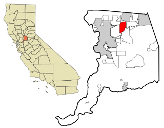
Carmichael is a census-designated place (CDP) in Sacramento County, California, United States. It is an unincorporated suburb in the Greater Sacramento metropolitan area. The population was 79,793 at the 2020 census.
Mercy Hospital or Mercy Medical Center could refer to the following hospitals in:

UC Davis Medical Center (UCDMC) is part of UC Davis Health and a major academic health center located in Sacramento, California. It is owned and operated by the University of California as part of its University of California, Davis campus. The medical center sits on a 142-acre (57 ha) campus (often referred to as the Sacramento Campus to distinguish it from the main campus in nearby Davis) located between the Elmhurst, Tahoe Park, and Oak Park residential neighborhoods. The site incorporates the land and some of the buildings of the former Sacramento Medical Center (which was acquired from the County of Sacramento in 1973) as well as much of the land (and two buildings) previously occupied by the California State Fair until its 1967 move to a new location.
Encina High School is an American 9-12 public school located in Arden-Arcade, California. It is a member of the San Juan Unified School District. While the school thrived during its early years of existence and into the 1980s, it has since suffered from low enrollment and been suggested for closure several times in its recent history. It includes the Advanced Path Program students.

Santa Clara Valley Medical Center, commonly known as Valley Medical Center or simply Valley Medical, is a prominent 731-bed public tertiary, teaching, and research hospital in San Jose, California. Located in the Fruitdale neighborhood of West San Jose, Valley Medical Center is the anchor facility of the Santa Clara County Health System, serving Santa Clara County. Valley Medical is home to numerous innovative research and care centers, such as the Rehabilitation Trauma Center, the only federally-designated spinal cord injury center in Northern California.

Grand Island is an island lying between Sycamore Slough and the Sacramento River. A post office operated at Grand Island from 1854 to 1919. It is shown, labeled "Taylor Island", on an 1850 survey map of the San Francisco Bay area made by Cadwalader Ringgold and an 1854 map of the area by Henry Lange.
Georgiana Slough, is a slough within Sacramento County, California. It is located in the Sacramento–San Joaquin River Delta, and links both the Sacramento River and the San Joaquin River above their confluence in the Delta near Pittsburg, at the head of Suisun Bay, through its connection with the Mokelumne River. The entrance to the slough on the Sacramento River is just below Walnut Grove, at 38°14′21″N121°30′59″W and runs between Tyler Island and Andrus Island to where it has its confluence with the Mokelumne River at 38°07′49″N121°34′40″W northwest of Bouldin Island just above that rivers confluence with the San Joaquin River.

Camp Kohler was located in the northeast corner of unincorporated Sacramento County, California, United States, until it was destroyed by a fire in 1947. Initially a camp for migrant farm workers, it became the Sacramento Assembly Center a temporary detention center for interned Japanese Americans in 1942. The site is one of 12 California assembly centers that share designation as California Historical Landmark No. 934. From 1943 to 1945 the camp was a training center for US World War II forces.
Kaiser Vacaville Medical Center is a Kaiser Permanente hospital in Vacaville, California, serving Solano County.
Dutton Island is a small island in Suisun Bay, California. It is part of Solano County, and included within Reclamation District 2127. Its coordinates are 38°04′54″N121°58′14″W. An 1850 survey map of the San Francisco Bay area made by Cadwalader Ringgold, as well as an 1854 map of the area by Henry Lange, shows an unlabeled island covering some of the area now occupied by Dutton Island.

Wheeler Island is a small island in Suisun Bay, California. It is part of Solano County; parts of it are included in Reclamation Districts 2127 and 2130. Its coordinates are 38°05′06″N121°56′15″W. An 1850 survey map of the San Francisco Bay area made by Cadwalader Ringgold, and an 1854 map by Henry Lange, show islands partially covering some of the current area of Wheeler Island, labeled "Davis Island" and "Warrington Island".
Sutter Island is a small island of the Sacramento River in California. It is bordered by the Sacramento River on the northeast, Steamboat Slough to the southease, and Sutter Slough to the west. It is located across the Sacramento River from Paintersville. It is part of Sacramento County, and managed by Reclamation District 349. Its coordinates are 38°17′37″N121°35′32″W. It is shown, labeled "Schoolcraft Island", on an 1850 survey map of the San Francisco Bay area made by Cadwalader Ringgold and an 1854 map of the area by Henry Lange.

Decker Island is a small island in the Sacramento-San Joaquin River delta, in California. It is part of Solano County. Its coordinates are 38.0904745°N 121.7191214°W. Part of the island is the Decker Island Wildlife Area, operated by the California Department of Fish and Wildlife.

Tyler Island is a small island in the San Joaquin River delta, part of Sacramento County, California. Its coordinates are 38.1729725°N 121.5474531°W. It is named after 1861 owner W.C. Tyler, and managed by Reclamation Districts 563 and 554.

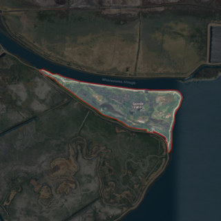
Brannan Island is a small island in the Sacramento–San Joaquin River Delta. It is part of Sacramento County, California, and is managed by Reclamation District 2067. Its coordinates are 38°07′19″N121°38′37″W, and the United States Geological Survey measured its elevation as −13 ft (−4.0 m) in 1981. A "Brannan Island", with the same location but a slightly different shape, is labeled on an 1850 survey map of the San Francisco Bay area made by Cadwalader Ringgold as well as an 1854 map of the area by Henry Lange.

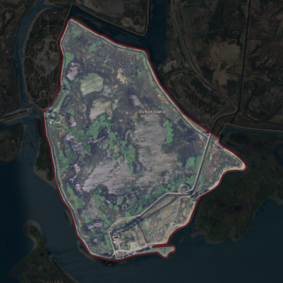
Ida Island is a small island in the Sacramento–San Joaquin River Delta. It is part of Sacramento County, California. Its coordinates are 38°10′14″N121°38′12″W, and the United States Geological Survey measured its elevation as 3 ft (0.91 m) in 1981. It appears on a 1978 USGS map of the area.

The Rio Blanco Tract is an island in the Sacramento–San Joaquin River Delta. It is part of San Joaquin County, California, and managed by Reclamation District 2114. Its coordinates are 38°04′46″N121°24′18″W, and the United States Geological Survey measured its elevation as 0 ft (0 m) in 1981. It appears on a 1952 USGS map of the area.

The Hastings Tract is an island in the Sacramento–San Joaquin River Delta. It is part of Solano County, California, and managed by Reclamation District 2060. Its coordinates are 38°16′19″N121°43′45″W, and the United States Geological Survey measured its elevation as 0 ft (0 m) in 1981.
Spinner Island is an island in Suisun Bay, an embayment of San Francisco Bay, downstream of the Sacramento–San Joaquin River Delta. It is part of Solano County, California, and not managed by any reclamation district. Its coordinates are 38°04′11″N121°52′10″W, and the United States Geological Survey measured its elevation as 0 ft (0 m) in 1981. It is shown in an 1850 survey map of the San Francisco Bay area made by Cadwalader Ringgold, as well as an 1854 map of the area by Henry Lange.

