Konya is a major city in central Turkey, on the southwestern edge of the Central Anatolian Plateau, and is the capital of Konya Province. During antiquity and into Seljuk times it was known as Iconium. In 19th-century accounts of the city in English its name is usually spelt Konia or Koniah. In the late medieval period, Konya was the capital of the Seljuk Turks' Sultanate of Rum, from where they ruled over Anatolia.

Anadoluhisarı, known historically as Güzelce Hisar is a medieval Ottoman fortress located in Istanbul, Turkey on the Anatolian (Asian) side of the Bosporus. The complex is the oldest surviving Turkish architectural structure built in Istanbul, and further gives its name to the neighborhood around it in the city's Beykoz district.

Üsküdar is a large and densely populated district of Istanbul, Turkey, on the Anatolian (Asian) shore of the Bosphorus. It is bordered to the north by Beykoz, to the east by Ümraniye, to the southeast by Ataşehir and to the south by Kadıköy; with Karaköy, Kabataş, Beşiktaş, and the historic city center of Fatih facing it on the opposite shore to the west. Üsküdar has been a conservative cultural center of the Anatolian side of Istanbul since Ottoman times with its numerous historic landmark and little mosques and dergahs. It is home to about half a million people.

Beşiktaş is a district and municipality of Istanbul Province, Turkey. Its area is 18 km2, and its population is 175,190 (2022). It is located on the European shore of the Bosphorus strait. It is bordered on the north by Sarıyer and Şişli, on the west by Kağıthane and Şişli, on the south by Beyoğlu, and on the east by the Bosphorus. Directly across the Bosphorus is the district of Üsküdar.

Avcılar is a municipality and district of Istanbul Province, Turkey. Its area is 50 km2, and its population is 452,132 (2022). It is on the European side of the city, just to the west of the Küçükçekmece inlet of the Sea of Marmara.

Bağcılar is a municipality and district of Istanbul Province, Turkey. Its area is 23 km2, and its population is 740,069 (2022). It is located on the European side of Istanbul, near the city centre, just north of Bahçelievler, between the two major ring roads, TEM and D100. The district is the fourth most populous in the Istanbul Municipality. Bağcılar developed rapidly between the 1970s and 1990s and is primarily residential in nature. The neighborhood is served by the Istanbul Metro and the T1 line of the Istanbul Tram. The mayor is Abdullah Özdemir from the Justice and Development Party, elected in April 2022.

Şile is a city and district in Istanbul, Turkey. The district of Şile is part of Istanbul Province, and the municipality of Şile is part of Istanbul Metropolitan Municipality. Bordering Şile is the province of Kocaeli to the east and south, and Istanbul districts of Pendik to the south, Çekmeköy to the southwest, and Beykoz to the west. The boundaries of Şile were expanded by the addition of the village of Esenceli from Beykoz district in 1987. Şile consists of Şile, Yeşilvadi and Teke subdistricts, and 58 villages. According to the 2007 census, the population of the district was 25,169, of which 9,831 lived in the city of Şile, 2,096 in the nearby town of Ağva (Yeşilçay) and 13,242 in surrounding villages. Popular resort Ağva is also a part of Şile. However, between June and September, the population rapidly increases because of the many residents of Istanbul who have summer houses in Şile.

Şişli is one of the 39 districts of Istanbul, Turkey. Located on the European side of the city, it is bordered by Beşiktaş to the east, Sarıyer to the north, Eyüp and Kağıthane to the west, and Beyoğlu to the south. In 2009, Şişli had a population of 316,058.
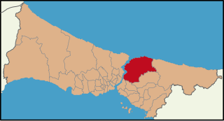
Beykoz, also known as Beicos and Beikos, is a municipality and district of Istanbul Province, Turkey. Its area is 310 km2, and its population is 247,875 (2022). It lies at the northern end of the Bosphorus on the Anatolian side. The name is believed to be a combination of the words bey and kos, which means "village" in Farsi. Beykoz includes an area from the streams of Küçüksu and Göksu to the opening of the Bosphorus into the Black Sea, and the villages in the hinterland as far as the Riva creek. The mayor is Murat Aydın (AKP).
Ataşehir is a municipality and district of Istanbul Province, Turkey. Its area is 25 km2, and its population is 423,127 (2022). It is located at the junction of the O-2 and O-4 motorways on the Anatolian (Asian) side of Istanbul. Its neighbours are the districts of Ümraniye to the north, Sancaktepe to the northeast, Maltepe to the east, Kadıköy to the south and Üsküdar to the west.

Yalova is a market-gardening town located in northwestern Turkey on the eastern coast of the Sea of Marmara. It is the seat of Yalova Province and Yalova District. Its population is 133,109 (2022). A largely modern town, it is best known for the spa resort at nearby Termal, a popular summer retreat for residents of Istanbul.

The Free Cause Party abbreviated as HÜDA PAR, Kurdish: Partiya Doza Azadî) is a Sunni Kurdish Islamist political party in Turkey.

Muhammed Ali Fatih Erbakan is a Turkish engineer and politician who is the founder and leader of the Islamic fundamentalist New Welfare Party (YRP). A son of Necmettin Erbakan, the former Prime Minister of Turkey who led the YRP's predecessor, the Welfare Party, he is the President of the Necmettin Erbakan Foundation.

Kazlıçeşme is one of the seven neighborhoods of Zeytinburnu district in Istanbul, Turkey. Chartered in 1957, it is the largest neighborhood of Zeytinburnu. The locality took its name from the historic fountain with a relief goose figure below the fountain's inscription, which dates it back to Hijri year AH 953.

The Merkez Türkiye project is a proposal for a planned megacity put forward by Turkey's main opposition Republican People's Party (CHP) on 21 May 2015, as part of their June 2015 general election campaign. The project plans to use Turkey's strategic geographical positioning to establish a centre for global trade and commerce in Central Anatolia. It was branded as Turkey's 'economic empowerment project' (Ekonomi Yükseliş Projesi) and was nicknamed 'the Project of the Century' (Yüzyılın projesi).
Akbaba is a neighbourhood in the municipality and district of Beykoz, Istanbul Province, Turkey. Its population is 2,771 (2022). It is home to the türbe of Akbaba Sultan, a Bektashi Sufi baba who participated in the Conquest of Constantinople and was a mentor of Ottoman Sultan Mehmet the Conqueror. Following the Conquest, he moved to this valley rich with spring waters and established a tekke with his dervish murids. The tekke was last revived by the Naqshbandi Shaykh Abdulhakim Efendi of Bukhara between 1876 and 1889.

Paşabahçe is a neighbourhood in the municipality and district of Beykoz, Istanbul Province, Turkey. Its population is 3,717 (2022). It is located on the Anatolian side of the Bosphorus.

The New Welfare Party is an Islamist political party in Turkey. It is the successor of the Welfare Party, which was banned in 1998. They adopt the National Outlook ideology.

Yalıköy is a neighbourhood in the municipality and district of Beykoz, Istanbul Province, Turkey. Its population is 5,107 (2022). It lies by the Anatolian/Asian side of the Bosphorus Strait. The name is a combination of two words: yalı and köy. Yalıköy is known for its historic wooden Ottoman style houses overlooking the waters of the Bosphorus. A skyscraper skyline can be seen across on the other side of the Bosphorus, the business district of Maslak. People of Greek, Turkish, Albanian, and Armenian origin used to live in the area. A fishing community thrives on the coast of Yalıköy.