Related Research Articles

Merrimac is a small town in Essex County, Massachusetts, United States, and on the southeastern border of New Hampshire, approximately 34 miles (55 km) northeast of Boston and 10 miles (16 km) west of the Atlantic Ocean. It was incorporated on April 11, 1876. It is situated along the north bank of the Merrimack River in the Merrimack Valley. The population was 6,723 at the 2020 census. Historically a mill town, it has long since become a largely residential community. It is part of the Greater Boston metropolitan area.
Lawrence Park Township is the only first class township in Erie County, Pennsylvania, United States. The population was 3,821 at the 2020 census, down from 4,048 at the 2000 census. The 2010 census counted a population of 3,982, for a decline of 1.6% during the decade. The entire township is also listed as a census-designated place.
Nichols is a village located in the Town of Nichols in Tioga County, New York, United States. The population was 512 at the 2010 census. It is part of the Binghamton Metropolitan Statistical Area. The name is taken from that of a local benefactor, Colonel Nichols.

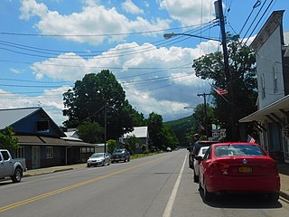
Merrimac Square is located in the center of the town of Merrimac, Massachusetts. It is the commercial, cultural and historical center of the town.

New Chardon Street is a street in downtown Boston, Massachusetts, United States, north of Government Center. It begins at Cambridge Street at Bowdoin Square, across from Bowdoin Street. The two-way street continues east across Congress Street, ending at Haymarket Square with access to the Sumner and Callahan Tunnels and the Central Artery, as well as local access to Washington Street North and the Surface Artery.

Massachusetts's 6th congressional district is located in northeastern Massachusetts. It contains most of Essex County, including the North Shore and Cape Ann, as well as part of Middlesex County. It is represented by Seth Moulton, who has represented the district since January 2015. The shape of the district went through minor changes effective from the elections of 2012 after Massachusetts congressional redistricting to reflect the 2010 census. The towns of Tewksbury and Billerica were added, along with a small portion of the town of Andover.
Whittier Regional Vocational Technical High School, also known as “Whittier Tech” and/or “Big Whittier,” was founded in 1972. Located in the city of Haverhill, MA, United States, the school currently serves about 1400 students, with a 12:1 student-teacher ratio. It serves many surrounding cities and towns primarily in the northern section of Essex County, accepting students from Haverhill, Newburyport, Newbury, West Newbury, Rowley, Amesbury, Merrimac, Georgetown, Groveland, Ipswich and Salisbury. The school was named in honor of local resident, Quaker poet, and slavery abolitionist John Greenleaf Whittier. Alongside this school, there is also a middle school called “J. G. Whittier Middle School” located in Haverhill also named after the poet.
Shavertown was a hamlet in Delaware County, New York. It was sacrificed and laid under water with the construction of the Pepacton Reservoir in 1954. Shavertown had a few hundred inhabitants, mostly reliant on the town's timber industry. The Delaware and Eastern Railroad ran through the town.

Merrimack Valley Transit, formerly known as Merrimack Valley Regional Transit Authority is a public, non-profit organization in Massachusetts, United States, charged with providing public transportation to an area consisting of the cities and towns of Amesbury, Andover, Boxford, Georgetown, Groveland, Haverhill, Lawrence, Merrimac, Methuen, Newbury, Newburyport, North Andover, Rowley, Salisbury and West Newbury, as well as a seasonal service to the popular nearby summer destination of Hampton Beach, New Hampshire.
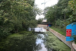
The Old River Lea is the former natural channel of the River Lea below Lea Bridge, in the London Borough of Hackney. The Old River forms a large meander from the Middlesex Filter Beds Weir to rejoin the main channel of the River Lee Navigation below Old Ford Lock, just west of the 2012 Olympic stadium.

Zoar is a hamlet in the town of Collins in Erie County, New York, United States. Though it is in Collins, mail is postmarked to the Gowanda ZIP code of 14070. It is located on the northern side of Zoar Valley.
Tamassee is an unincorporated community and census-designated place (CDP) located in northwestern Oconee County, South Carolina, United States. It was first listed as a CDP in the 2020 census with a population of 60.

Congress Street in Boston, Massachusetts, is located in the Financial District and South Boston. It was first named in 1800. It was extended in 1854 as far as Atlantic Avenue, and in 1874 across Fort Point Channel into South Boston. Today's Congress Street consists of several segments of streets, previously named Atkinson's Street, Dalton Street, Gray's Alley, Leverett's Lane, Quaker Lane, and Shrimpton's Lane.
Miroševce is a village in the municipality of Leskovac, Serbia. According to the 2011 census, the village has a population of 903 people.
The Cwm Llwyd Fault is a fault in the west of the Black Mountain of South Wales. It runs north, parallel to the A4069 road, for over 4 km from near Brynaman to meet the Carreg Cennen Disturbance near Brest Cwm Llwyd. It moved as a sinistral strike-slip fault during the Variscan Orogeny. Together with the Llwyn Celyn Fault it formed a left-stepping offset that created a pull apart structure, which preserved the Cwm Llwyd Outlier of Namurian rocks.

The Kolar River is a river of Nagpur district, Maharashtra, India, flowing southeast from above the town of Saoner to its juncture with the Kanhan River. It is in the Godavari river basin. The Kolar River forms the boundary between Saoner taluka and Ramtek taluka.
Monegaw Springs is an unincorporated community in St. Clair County, in the U.S. state of Missouri.
Sarvis Point is an unincorporated community in southeastern Webster County, in the U.S. state of Missouri. The community was located on the north bank of Finley Creek along County Road 321.
References
- ↑ "Merrimac Open Space Committee - Merrimac Trail Info and Maps". sites.google.com. Retrieved 2023-09-30.
42°50′21″N71°1′11″W / 42.83917°N 71.01972°W
| | This Essex County, Massachusetts geography–related article is a stub. You can help Wikipedia by expanding it. |