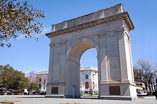
Newport News is an independent city in southeastern Virginia, United States. At the 2020 census, the population was 186,247. Located in the Hampton Roads region, it is the fifth-most populous city in Virginia and 140th-most populous city in the United States. The city is at the southeastern end of the Virginia Peninsula, on the northern shore of the James River to the river's mouth on the harbor of Hampton Roads.

James City County is a county located in the Commonwealth of Virginia. As of the 2020 census, the population was 78,254. Although politically separate from the county, the county seat is the adjacent independent city of Williamsburg.

Hampton Roads is the name of both a body of water in the United States that serves as a wide channel for the James, Nansemond, and Elizabeth rivers between Old Point Comfort and Sewell's Point near where the Chesapeake Bay flows into the Atlantic Ocean, and the surrounding metropolitan region located in the southeastern Virginia and northeastern North Carolina portions of the Tidewater Region.

The James River is a river in Virginia that begins in the Appalachian Mountains and flows from the confluence of the Cowpasture and Jackson Rivers in Botetourt County 348 miles (560 km) to the Chesapeake Bay. The river length extends to 444 miles (715 km) if the Jackson River is included, the longer of its two headwaters. It is the longest river in Virginia. Jamestown and Williamsburg, Virginia's first colonial capitals, and Richmond, Virginia's current capital, lie on the James River.

The Virginia Peninsula is located in southeast Virginia, bounded by the York River, James River, Hampton Roads and Chesapeake Bay. It is sometimes known as the Lower Peninsula to distinguish it from two other peninsulas to the north, the Middle Peninsula and the Northern Neck.

South Hampton Roads is a region located in the extreme southeastern portion of Virginia's Tidewater region in the United States with a total population of 1,177,742 as of 2020. It is part of the Virginia Beach-Norfolk-Newport News, VA-NC MSA, which itself has a population of 1,780,059 as of 2020.
Penniman was an unincorporated town in northwestern York County, Virginia, on the south bank of the York River six miles (9.7 km) northeast of Williamsburg. This was on the Virginia Peninsula and near the Hampton Roads region of southeastern Virginia in the United States.

Transportation in the Commonwealth of Virginia is by land, sea and air. Virginia's extensive network of highways and railroads were developed and built over a period almost 400 years, beginning almost immediately after the founding of Jamestown in 1607, and often incorporating old established trails of the Native Americans.

State Route 168 is a primary state highway in the South Hampton Roads region of the U.S. state of Virginia. It runs from the border with North Carolina through the independent cities of Chesapeake and Norfolk where it ends in the Ocean View area near the Hampton Roads Bridge-Tunnel.

State Route 143 is a primary state highway in the U.S. state of Virginia. The state highway runs 35.39 miles (56.95 km) from Camp Peary near Williamsburg east to U.S. Route 258 at Fort Monroe in Hampton. SR 143 is a major local thoroughfare on the Virginia Peninsula portion of the Hampton Roads metropolitan area. The state highway is named Merrimac Trail through the independent city of Williamsburg and adjacent portions of York County and James City County. SR 143 follows Jefferson Avenue through the city of Newport News from the Williamsburg area past Virginia Peninsula Regional Jail to near Downtown Newport News. The state highway, which mostly runs northwest–southeast, heads northeast from Newport News, serving as one highway connecting the downtown areas of Newport News and Hampton. SR 143 parallels both US 60 and Interstate 64 (I-64) extensively, and sometimes very closely, throughout its course. The state highway also runs concurrently with US 60 in Hampton and with US 17 in Newport News.
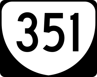
State Route 351 is a primary state highway in the U.S. state of Virginia. Known for most of its length as Pembroke Avenue, the state highway runs 8.81 miles (14.18 km) from U.S. Route 60 in Newport News east to Second Street in Hampton.

U.S. Route 60 (US 60) in the Commonwealth of Virginia runs 303 miles (488 km) west to east through the central part of the state, generally close to and paralleling the Interstate 64 corridor, except for the crossing of the Blue Ridge Mountains, and in the South Hampton Roads area.

Interstate 64 (I-64) in the US state of Virginia runs east–west through the middle of the state from West Virginia to the Hampton Roads region, for a total of 299 miles (481 km). From the West Virginia state line to Chesapeake, it passes through the major cities of Lexington, Staunton, Charlottesville, the state capital of Richmond, Newport News, Hampton, and Norfolk. It is notable for crossing the mouth of the harbor of Hampton Roads on the Hampton Roads Bridge–Tunnel (HRBT), the first bridge–tunnel to incorporate artificial islands, concurrent with U.S. Route 60 (US 60). Also noteworthy is a section through Rockfish Gap, a wind gap in the Blue Ridge Mountains, which was equipped with an innovative system of airport-style runway lighting embedded into the pavement to aid motorists during periods of poor visibility due to fog or other conditions.
Located in the southeastern corner of the state, Norfolk is economically and culturally important to Virginia. A variety of transportation modes have developed around the city's importance and somewhat unusual geography.
Queen's Creek is located in York County in the Virginia Peninsula area of the Hampton Roads region of southeastern Virginia in the United States. From a point of origin near the Waller Mill Reservoir in western York County, it flows northeasterly across the northern half of the Peninsula as a tributary of the York River.
The city of Williamsburg, Virginia has a full range of transport facilities. Williamsburg is served by the Newport News/Williamsburg International Airport, and by two larger but more distant airports. The city is linked to several Interstate and State highways. A transport hub - the Williamsburg Transportation Center - serves bus and rail passengers. Motor traffic is restricted in the historic area, and the city as a whole is more "walkable" than the US norm. Cycling routes are also being provided.

Historically, the harbor was the key to the Hampton Roads area's growth, both on land and in water-related activities and events. Ironically, the harbor and its tributary waterways were both important transportation conduits and obstacles to other land-based commerce and travel. For hundreds of years, state and community leaders have worked to develop solutions to accommodate both.

The history of Hampton Roads dates to 1607, when Jamestown was founded. Two wars have taken place in addition to many other historical events.
Anderson's Corner, Virginia is located in James City County near the unincorporated community of Toano. Located at the intersection of U.S. Route 60 and State Route 30, Anderson's Corner was the western terminus of State Route 168 a new four-laned highway also known as the Merrimack Trail which was established in the pre-World War II era to supplement the heavily traveled Route 60 through the Williamsburg where the Colonial Williamsburg Restoration funded by Abby and John D. Rockefeller Jr. had added to traffic, as well as the growing Virginia Peninsula area, connecting via harbor ferry with similarly designated roads in South Hampton Roads.