
A canyon, or gorge, is a deep cleft between escarpments or cliffs resulting from weathering and the erosive activity of a river over geologic time scales. Rivers have a natural tendency to cut through underlying surfaces, eventually wearing away rock layers as sediments are removed downstream. A river bed will gradually reach a baseline elevation, which is the same elevation as the body of water into which the river drains. The processes of weathering and erosion will form canyons when the river's headwaters and estuary are at significantly different elevations, particularly through regions where softer rock layers are intermingled with harder layers more resistant to weathering.

Canyoning is a type of mountaineering that involves travelling in canyons using a variety of techniques that may include other outdoor activities such as walking, scrambling, climbing, jumping, abseiling (rappelling), and swimming.

The Royal Gorge is a canyon of the Arkansas River located west of Cañon City, Colorado. The canyon begins at the mouth of Grape Creek, about 2 mi (3.2 km) west of central Cañon City, and continues in a west-northwesterly direction for approximately 6 mi (9.7 km) until ending near U.S. Route 50. Being one of the deepest canyons in Colorado, it is also known as the Grand Canyon of the Arkansas (River), with a maximum depth of 1,250 ft (380 m). The canyon is also very narrow, measuring from 50 ft (15 m) wide at its base to 300 ft (91 m) wide at its top, as it carves a path through the granite formations below Fremont Peak and YMCA Mountain, which rise above the north and south rims, respectively.

Black Canyon of the Gunnison National Park is an American national park located in western Colorado and managed by the National Park Service. There are two primary entrances to the park: the south rim entrance is located 15 miles (24 km) east of Montrose, while the north rim entrance is 11 miles (18 km) south of Crawford and is closed in the winter. The park contains 12 miles (19 km) of the 48-mile (77 km) long Black Canyon of the Gunnison River. The national park itself contains the deepest and most dramatic section of the canyon, but the canyon continues upstream into Curecanti National Recreation Area and downstream into Gunnison Gorge National Conservation Area. The canyon's name owes itself to the fact that parts of the gorge only receive 33 minutes of sunlight a day, according to Images of America: The Black Canyon of the Gunnison. In the book, author Duane Vandenbusche states, "Several canyons of the American West are longer and some are deeper, but none combines the depth, sheerness, narrowness, darkness, and dread of the Black Canyon."

The Verdon Gorge is a river canyon located in the Provence-Alpes-Côte d'Azur region of Southeastern France. It is about 25 km (15.5 mi) long and up to 700 metres (0.4 mi) deep. It was formed by the Verdon River, which is named for its turquoise-green colour, one of the location's distinguishing characteristics. In between the towns of Castellane and Moustiers-Sainte-Marie, the river has cut a ravine to a depth of 700 meters through the limestone mass. At the end of the canyon, the Verdon flows into the artificial Lake of Sainte-Croix.

The Yarlung Tsangpo Grand Canyon, also known as the Yarlung Zangbo Grand Canyon, the Tsangpo Canyon, the Brahmaputra Canyon or the Tsangpo Gorge, is a canyon along the Yarlung Tsangpo River in Tibet Autonomous Region, China. It is the deepest canyon in the world, and at 504.6 kilometres (313.5 mi) is slightly longer than the Grand Canyon in the United States, making it one of the world's largest. The Yarlung Tsangpo originates near Mount Kailash and runs east for about 1,700 kilometres (1,100 mi), draining a northern section of the Himalayas before it enters the gorge just downstream of Pei, Tibet, near the settlement of Zhibe. The canyon has a length of about 240 kilometres (150 mi) as the gorge bends around Mount Namcha Barwa and cuts its way through the eastern Himalayan range. Its waters drop from about 2,900 metres (9,500 ft) near Pei to about 1,500 metres (4,900 ft) at the end of the Upper Gorge where the Po Tsangpo River enters. The river continues through the Lower Gorge to the Indian border at an elevation of 660 metres (2,170 ft). The river then enters Arunachal Pradesh and eventually becomes the Brahmaputra.
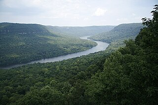
The Tennessee River Gorge is a 26-mile (42 km) canyon formed by the Tennessee River known locally as Cash Canyon. It is the fourth largest river gorge in the Eastern United States. The gorge is cut into the Cumberland Plateau as the river winds its way into Alabama from Tennessee. The Tennessee River Gorge was also known as Walden Gorge. Walden Ridge originally extended across the present path of the Tennessee River at the gorge to Sand Mountain.

The Fraser Canyon is a major landform of the Fraser River where it descends rapidly through narrow rock gorges in the Coast Mountains en route from the Interior Plateau of British Columbia to the Fraser Valley. Colloquially, the term "Fraser Canyon" is often used to include the Thompson Canyon from Lytton to Ashcroft, since they form the same highway route which most people are familiar with, although it is actually reckoned to begin above Williams Lake, British Columbia at Soda Creek Canyon near the town of the same name.

Cimarron is an unincorporated rural hamlet in Montrose County, Colorado, United States. It is located on the northern side of U.S. Highway 50, 19 miles from the town of Montrose to its west, and 42 miles from Gunnison, Colorado Gunnison to its east. There is a store with fuel pumps and a post office at Cimarron. The post office services the rural ZIP Code 81220 area.

White Canyon is a canyon in San Juan County, Utah, United States.

The Linville Gorge Wilderness is the third largest wilderness area in North Carolina and one of only two wilderness gorges in the Southern United States. Maintained by the United States Forest Service, it comprises 11,786 acres (47.7 km2) around the Linville River, and is situated inside the Pisgah National Forest. The river is approximately 1,400 feet below the ridge, thus hiking in and out of the Gorge is challenging and enjoyable for those who like serious hiking. The plant and animal community is extremely diverse, with a dense hardwood/pine forest and a wide variety of smaller trees and other plants as well as bear, fox, raccoon, trout, grouse, wild turkey, vultures, owls, hawks, copperheads, and timber rattlesnakes.

The Manuka State Wayside Park is a state park of 13.4 acres (5.4 ha) with an arboretum located approximately 19 miles (31 km) west of Naʻalehu, on the Mamalahoa Highway section of the Hawaii Belt Road, on the island of Hawaii, Hawaii, coordinates 19°6′33″N155°49′33″W

The Royal Gorge Route Railroad is a heritage railroad based in Cañon City, Colorado. A 1950s-era train makes daily 2-hour excursion runs from the Santa Fe Depot through the Royal Gorge along a famous section of the former Denver and Rio Grande Western Railroad.

Rugova Canyon or Rugova Gorge is a river canyon near Peja in Western Kosovo, in the Accursed Mountains, close to the border with Montenegro. With a length of 25 km (16 mi) and a depth up to 1,000 meters, Rugova is considered to be one of Europe's longest and deepest canyons. It was created by water erosion and the retreat of the Peja glacier. The Peja Bistrica river cuts through the canyon.

Bright Angel Creek is an American body of water located at the bottom of the Grand Canyon National Park flowing into the Colorado River at the end of the North Kaibab Trail on the north side of the river. The creek originates from Roaring Springs that emerge from a cliff along the North Kaibab Trail and drains to the Colorado. The North Kaibab Trail largely follows the creek, including through "the Box," a narrow, high-walled part of the trail that becomes extremely hot in daylight during the summer months.
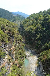
The Osum Gorge is a river gorge in southern Albania, near the town of Çorovodë. The river Osum, which passes through the town of Berat, flows through the canyon.

Eagle Creek is a tributary of the Columbia River in Multnomah and Hood River counties in the U.S. state of Oregon. It cuts through a narrow canyon in its 3,200 feet (980 m) descent to the Columbia River Gorge and is known for its concentration of 13 waterfalls in about 5 miles (8.0 km) distance. Eight major falls are on Eagle Creek and the East Fork Eagle Creek itself, while five are on its tributaries.

The Sarakina Gorge is a canyon in the southeastern part of Crete, Greece. It is located about 15 km west of Ierapetra and a few kilometres upcountry of Myrtos, near the small village of Mithi.

Silverado Canyon is a roughly 2,500-foot-deep gorge in the Santa Ana Mountains, in the U.S. state of California. The small stream it is associated with, Silverado Creek, rises on the north slope of Modjeska Peak at the elevation of 3,980 feet (1,210 m) and flows north and west, past the town of Silverado to join Santiago Creek at 942 feet (287 m) after a journey of just under 5 miles (8.0 km). The main branch, Ladd Canyon, is just over 3 miles (4.8 km) long. Its stream arises on the east flank of Pleasants Peak at about 3,590 feet (1,090 m) and flows southwest into the main stem at about 1,178 feet (359 m) near Silverado. They are part of the Santa Ana River watershed. A hiking trail/fire road runs the entire length of the canyon.

Clifton Gorge State Nature Preserve, in Greene County, Ohio, is located three miles east of Yellow Springs, Ohio and immediately southwest of Clifton, Ohio. The Preserve constitutes 268 acres of gorges along two miles of the Little Miami River.