
A census is the procedure of systematically acquiring, recording, and calculating population information about the members of a given population, usually displayed in the form of statistics. This term is used mostly in connection with national population and housing censuses; other common censuses include censuses of agriculture, traditional culture, business, supplies, and traffic censuses. The United Nations (UN) defines the essential features of population and housing censuses as "individual enumeration, universality within a defined territory, simultaneity and defined periodicity", and recommends that population censuses be taken at least every ten years. UN recommendations also cover census topics to be collected, official definitions, classifications, and other useful information to coordinate international practices.

Demographic features of the population of Madagascar include population density, ethnicity, education level, health of the populace, economic status, religious affiliations and other aspects of the population.

The National Telecommunications and Information Administration (NTIA) is a bureau of the United States Department of Commerce that serves as the president's principal adviser on telecommunications policies pertaining to the United States' economic and technological advancement and to regulation of the telecommunications industry.

The Chicago metropolitan area, also referred to as Chicagoland, is the largest metropolitan statistical area in the U.S. state of Illinois, and the Midwest, containing the City of Chicago along with its surrounding suburbs and satellite cities. Encompassing 10,286 square mi (28,120 km2), the metropolitan area includes the city of Chicago, its suburbs and hinterland, that span 13 counties across northeast Illinois and northwest Indiana. The MSA had a 2020 census population of 9,618,502 and the combined statistical area, which spans 19 counties and additionally extends into southeast Wisconsin, had a population of nearly 10 million people. The Chicago area is the third-largest metropolitan area in the United States and the fourth-largest metropolitan area in North America, and the largest in the Great Lakes megalopolis. Its urban area is one of the 40 largest in the world.

Garfield Ridge is the 56th of Chicago's 77 community areas. Located 10 miles (16 km) from the Loop, it is on the city's far southwest side. As of 2017, the area had 36,396 inhabitants.

The demographics of Chicago show that it is a very large, and ethnically and culturally diverse metropolis. It is the third largest city and metropolitan area in the United States by population. Chicago was home to over 2.7 million people in 2020, accounting for over 25% of the population in the Chicago metropolitan area, home to approximately 9.6 million.
Geodemography is the study of people based on where they live; it links the sciences of demography, the study of human population dynamics, and geography, the study of the locational and spatial variation of both physical and human phenomena on Earth, along with sociology. It includes the application of geodemographic classifications for business, social research and public policy but has a parallel history in academic research seeking to understand the processes by which settlements evolve and neighborhoods are formed. Geodemographic systems estimate the most probable characteristics of people based on the pooled profile of all people living in a small area near a particular address.

Montbello is a neighborhood of Denver, Colorado, located in the far northeast of the city. It is bounded on its north side by E 56th Avenue and the Rocky Mountain Arsenal National Wildlife Refuge, on its south side by the I-70/I-225 junction, by Peoria Street on its western confine and Chambers Road on its east.

The Lyndon B. Johnson School of Public Affairs is a graduate school at the University of Texas at Austin that was founded in 1970. The school offers training in public policy analysis and administration in government and public affairs-related areas of the private and nonprofit sectors. Degree programs include a Master of Public Affairs (MPAff), a mid-career MPAff sequence, 16 MPAff dual degree programs, a Master of Global Policy Studies (MGPS), eight MGPS dual degree programs, an Executive Master of Public Leadership, and a Ph.D. in public policy.
The Furman Center for Real Estate and Urban Policy is a joint center at New York University School of Law and the NYU Wagner School of Public Service. The Furman Center was established in 1995 to create a place where people interested in affordable housing and land use issues could turn to for factual, objective research and information. Since that time, the Furman Center has become an authority on such matters in New York City. The Furman Center has a three-part mission, including providing objective academic research about land use, real estate, housing and urban affairs, with a particular focus on New York City, promoting intense debate and productive discussion among elected, academic, and industry leaders, and presenting essential data and analysis about the state of New York City's housing and neighborhoods.
The Graduate School of Public and International Affairs (GSPIA) is one of 17 schools comprising the University of Pittsburgh. Founded in 1957 to study national and international public administration, GSPIA prides itself on its "Local to Global" distinction. As of 2018, it is one of only two policy schools with programs in the top 20 for both International Relations and City Management and Urban Policy. The former mayor of Pittsburgh, Bill Peduto, is a GSPIA alumnus.
The District of Columbia is a federal district with an ethnically diverse population. In 2020, the District had a population of 689,545 people, with a resident density of 11,515 people per square mile.
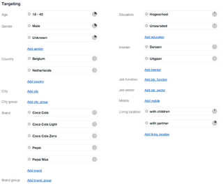
Targetedadvertising or data-driven marketing is a form of advertising, including online advertising, that is directed towards an audience with certain traits, based on the product or person the advertiser is promoting.
Residential segregation is the physical separation of two or more groups into different neighborhoods—a form of segregation that "sorts population groups into various neighborhood contexts and shapes the living environment at the neighborhood level". While it has traditionally been associated with racial segregation, it generally refers to the separation of populations based on some criteria.
Karol Józef Krótki, FRSC was a renowned Polish Canadian demographer who, at various times, lived and worked in Poland, the United Kingdom, Sudan, Pakistan, Morocco and Canada. Professor Krotki was elected to the Royal Society of Canada in 1979.
The Making Connections Survey is a neighborhood-based, longitudinal and cross-sectional survey funded by the Annie E. Casey Foundation. It serves as an evaluation of a larger initiative supported by the foundation and was designed to collect data measuring how neighborhood change affects the well-being of children. The Making Connections Survey was conducted by National Opinion Research Center at the University of Chicago between 2002 and 2011 with residents in ten low-income communities across the United States. The final survey dataset includes responses from roughly 28,000 interviews at three points in time.

Concentrated poverty concerns the spatial distribution of socio-economic deprivation, specifically focusing on the density of poor populations. Within the United States, common usage of the term concentrated poverty is observed in the fields of policy and scholarship referencing areas of "extreme" or "high-poverty." These are defined by the US census as areas where "40 percent of the tract population [lives] below the federal poverty threshold." A large body of literature argues that areas of concentrated poverty place additional burdens on poor families residing within them, burdens beyond what these families' individual circumstances would dictate. Research also indicates that areas of concentrated poverty can have effects beyond the neighborhood in question, affecting surrounding neighborhoods not classified as "high-poverty" and subsequently limiting their overall economic potential and social cohesion. Concentrated poverty is a global phenomenon, with prominent examples world-wide. Despite differing definitions, contributing factors, and overall effects, global concentrated poverty retains its central theme of spatial density. Multiple programs have attempted to ameliorate concentrated poverty and its effects within the United States, with varying degrees of progress and to sometimes detrimental effect.
Julian Wolpert is Bryant Professor Emeritus of Geography, Public Affairs, and Urban Planning at Princeton University's Woodrow Wilson School, where he taught from 1973 to 2005 and chaired the Program in Urban and Regional Planning. He was previously a member of the Regional Science Department at the University of Pennsylvania (1963–73).
Global Internet usage is the number of people who use the Internet worldwide.

This is a list of food desert issues and solutions by country.