
Union County is a county located in the U.S. state of North Carolina. As of the 2020 census, the population was 238,267. Its county seat is Monroe. Union County is included in the Charlotte-Concord-Gastonia, NC-SC Metropolitan Statistical Area.
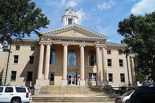
Pitt County is a county located in the inner banks of the U.S. state of North Carolina. As of the 2020 census, the population was 170,243, making it the fourteenth-most populous county in North Carolina. Its county seat is Greenville.

Hertford County is a county located in the U.S. state of North Carolina. As of the 2020 census, the population was 21,552. Its county seat is Winton. It is classified within the region known in the 21st century as the Inner Banks.

Harrisburg, a northeastern suburb of Charlotte, is a city in Cabarrus County, North Carolina, United States. The population was estimated to be 16,576 as of 1 July 2019.
Cornelius is a suburban town located along Lake Norman in northern Mecklenburg County, North Carolina, United States. It is a major suburb in the Charlotte metropolitan area. The population was 24,866 at the 2010 census.

Matthews is a town in southeastern Mecklenburg County, North Carolina, United States. It is a suburb of Charlotte. The population was 27,198 according to the 2010 Census.

Indian Trail is a suburban town in Union County, North Carolina, United States. A part of the Charlotte metropolitan area, Indian Trail has grown rapidly in the 21st century, going from 1,942 residents in 1990 to 39,997 in 2020. Every Fourth of July the town holds an annual parade which is one of the biggest parades in the Charlotte area.

The Piedmont Triad is a metropolitan region in the north-central part of the U.S. state of North Carolina anchored by three cities: Greensboro, Winston-Salem, and High Point. This close group of cities lies in the Piedmont geographical region of the United States and forms the basis of the Greensboro–Winston-Salem–High Point Combined Statistical Area. As of 2012, the Piedmont Triad has an estimated population of 1,611,243 making it the 33rd largest combined statistical area in the United States.

The Yadkin River is one of the longest rivers in the US state of North Carolina, flowing 215 miles (346 km). It rises in the northwestern portion of the state near the Blue Ridge Parkway's Thunder Hill Overlook. Several parts of the river are impounded by dams for water, power, and flood control. The river becomes the Pee Dee River at the confluence of the Uwharrie River south of the community of Badin and east of the town of Albemarle. The river then flows into South Carolina near Cheraw, which is at the Fall Line. The entirety of the Yadkin River and the Great Pee Dee River is part of the Yadkin-Pee Dee River Basin.

Crowders Mountain State Park is a 5,217-acre (21.11 km2) North Carolina state park in Gaston County, North Carolina in the United States. It is near Kings Mountain, North Carolina and on the outskirts of Gastonia, North Carolina, it includes the peaks of Crowder's Mountain and The Pinnacle. Crowders Mountain is named for Crowders Creek which originates near its base. The cliffs are a popular destination for rock climbers.

Cherokee is a census-designated place (CDP) in Swain and Jackson counties in Western North Carolina, United States, within the Qualla Boundary land trust. Cherokee is located in the Oconaluftee River Valley around the intersection of U.S. Routes 19 and 441. As of the 2020 census, the CDP had a population of 2,195. It is the capital of the federally recognized Eastern Band of Cherokee Indians, one of three recognized Cherokee tribes and the only one in North Carolina.

The Qualla Boundary or The Qualla is territory held as a land trust by the United States government for the federally recognized Eastern Band of Cherokee Indians, who reside in western North Carolina. The area is part of the large historic Cherokee territory in the Southeast, which extended into eastern Tennessee, western South Carolina, northern Georgia and Alabama. Currently, the largest contiguous portion of the Qualla lies in Haywood, Swain, and Jackson counties and is centered on the community of Cherokee, which serves as the tribal capital of the Eastern Band of Cherokee Indians. Smaller, discontiguous parcels also lie in Graham and Cherokee counties, near the communities of Snowbird and Murphy respectively.
WRCM is a listener-supported, non-commercial FM radio station licensed to Wingate, North Carolina and serving the Charlotte metropolitan area. It airs a Contemporary Christian radio format and identifies itself as "K-LOVE". It is owned by the Educational Media Foundation, based in Rocklin, California, a non-profit ministry. Some listeners can also hear K-LOVE on 94.1 WWLV in Lexington, North Carolina or on 88.3 WLXK in Boiling Springs, North Carolina.
Catawba College is a private college in Salisbury, North Carolina. Founded in 1851 by the North Carolina Classis of the Reformed Church in Newton, the college adopted its name from its county of origin, Catawba County, before moving to its current home of Salisbury in 1925. Catawba College still holds loose ties with the successor to the Reformed Church, the United Church of Christ. It offers over 70 undergraduate degrees.

Carter Gymnasium is a 947-seat multi-purpose arena in Buies Creek, North Carolina. It was previously home to the Campbell University Fighting Camels men's basketball and women's basketball teams. It was one of the smallest college basketball venues in Division I. The building was named for textile executive Howard Carter. Built in 1952 and opened in 1953, the dimensions of the basketball court are smaller than regulation, but a grandfather clause allowed Campbell University to continue its tenure in the division. The Fighting Camels began play in 2008 in the new John W. Pope, Jr. Convocation Center. The new $30 million arena seats 3,000 spectators for athletic events.

The Oconaluftee Indian Village is a replica of an 18th-century eastern Cherokee community founded in 1952 and located along the Oconaluftee River in Cherokee, North Carolina, United States.
WHPE-FM is a radio station licensed to High Point, North Carolina, and serving the Piedmont Triad region of North Carolina, including Greensboro and Winston-Salem. The station broadcasts a Conservative Christian talk and teaching radio format and is owned by the Charlotte-based Bible Broadcasting Network, which has Christian stations around the U.S. National religious leaders heard on WHPE-FM include Adrian Rogers, Chuck Swindoll, Joni Eareckson Tada and J. Vernon McGee.
Brandon Oaks is a neighborhood located in Union County, North Carolina. Its main road is Brandon Oaks Parkway.

Overhill Cherokee was the term for the Cherokee people located in their historic settlements in what is now the U.S. state of Tennessee in the Southeastern United States, on the western side of the Appalachian Mountains. This name was used by 18th-century European traders and explorers from British colonies along the Atlantic coast, as they had to cross the mountains to reach these settlements.

Goose Creek Township, population 14,773, is one of nine townships in Union County, North Carolina. Goose Creek Township is 83.10 square miles (215.2 km2) in size and is located in north-central Union County. This township includes a small part of the City of Monroe, plus parts of the Towns of Fairview (entirely), Indian Trail, Stallings, and Unionville.
