- This is a sub-article to Białystok
Metropolitan Białystok - a metropolitan area designated by the Governor of the Regulation No. 52/05 of 16 May 2005 [1] in order to help economically develop the region.
In 2006, the metropolitan area population was 450,254 inhabitants. [2] Covering the area of 1.521 km ², it had population density of about 265 people per one km2. Among urban residents were more women - 192 thousand. on 100 men, 108 women on average.
The municipalities adjacent to Białystok are slowly losing their agricultural character, becoming the residential suburban neighborhoods.[ citation needed ]
The metropolitan area includes:
- the city of Białystok,
- the villages in Gmina Choroszcz:

Klepacze is a village in the administrative district of Gmina Choroszcz, within Białystok County, Podlaskie Voivodeship, in north-eastern Poland. It lies approximately 7 kilometres (4 mi) south-east of Choroszcz and 7 km (4 mi) west of the regional capital Białystok.
Krupniki is a village in the administrative district of Gmina Choroszcz, within Białystok County, Podlaskie Voivodeship, in north-eastern Poland. It lies approximately 6 kilometres (4 mi) east of Choroszcz and 8 km (5 mi) north-west of the regional capital Białystok.

Łyski is a village in the administrative district of Gmina Choroszcz, within Białystok County, Podlaskie Voivodeship, in north-eastern Poland. It lies approximately 5 kilometres (3 mi) north-east of Choroszcz and 10 km (6 mi) north-west of the regional capital Białystok.
- the villages in Gmina Dobrzyniewo Duże:
- Bohdan, Borsukówka, Chraboły, Dobrzyniewo Duże, Dobrzyniewo Fabryczne*, Dobrzyniewo Kościelne*, Fasty*, Gniła, Jaworówka, Kozińce, Kulikówka, Krynice, Letniki, Leńce, Nowe Aleksandrowo*, Obrubniki, Ogrodniki*, Pogorzałki, Ponikła, Podleńce, Szaciły and Zalesie

Bohdan is a village in the administrative district of Gmina Dobrzyniewo Duże, within Białystok County, Podlaskie Voivodeship, in north-eastern Poland. It lies approximately 4 kilometres (2 mi) north-east of Dobrzyniewo Duże and 13 km (8 mi) north-west of the regional capital Białystok.

Borsukówka is a village in the administrative district of Gmina Dobrzyniewo Duże, within Białystok County, Podlaskie Voivodeship, in north-eastern Poland. It lies approximately 7 kilometres (4 mi) north of Dobrzyniewo Duże and 20 km (12 mi) north-west of the regional capital Białystok.
Chraboły is a village in the administrative district of Gmina Dobrzyniewo Duże, within Białystok County, Podlaskie Voivodeship, in north-eastern Poland.
- the villages in Gmina Juchnowiec Kościelny:
- the city of Supraśl and the villages in Gmina Supraśl:
- Grabówka, Henrykowo, Karakule and Ogrodniczki
- the city of Wasilków and the villages in Gmina Wasilków:
- Dąbrówki, Katrynka, Jurowce*, Osowicze*, Sochonie*, Studzianki, Nowodworce*, Sielachowskie*, Wólka Poduchowna, Wólka-Przedmieście and Woroszyły,
- the villages in Gmina Zabłudów:

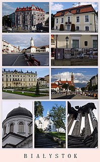
Białystok is the largest city in northeastern Poland and the capital of the Podlaskie Voivodeship. Białystok is the tenth-largest city in Poland, second in terms of population density, and thirteenth in area.

Gmina Choroszcz is an urban-rural gmina in Białystok County, Podlaskie Voivodeship, in north-eastern Poland. Its seat is the town of Choroszcz, which lies approximately 13 kilometres (8 mi) west of the regional capital Białystok.

Jeroniki is a village in the administrative district of Gmina Choroszcz, within Białystok County, Podlaskie Voivodeship, in north-eastern Poland. It lies approximately 4 kilometres (2 mi) north-east of Choroszcz and 10 km (6 mi) west of the regional capital Białystok.
* village added via Regulation No. 2 / 2008 of 28 January 2008 amending the Decree of 29 September 2006 on the designation of Metropolitan Białystok. [3]


