
Panama City, also known as Panama, is the capital and largest city of Panama. It has a total population of 1,086,990, with over 2,100,000 in its urban area. The city is located at the Pacific entrance of the Panama Canal, in the province of Panama. The city is the political and administrative center of the country, as well as a hub for banking and commerce.

The Sierra Nevada de Santa Marta is an isolated mountain range in northern Colombia, separate from the Andes range that runs through the north of the country. Reaching an elevation of 5,700 m (18,700 ft) just 42 km (26 mi) from the Caribbean coast, the Sierra Nevada is the highest coastal range in the tropics, and one of the highest coastal ranges in the world, being 250 metres (820 ft) shorter than the Saint Elias Mountains in Canada. The Sierra Nevada encompasses about 17,000 km2 (6,600 sq mi) and serves as the source of 36 rivers. The range is in the Departments of Magdalena, Cesar and La Guajira.

Manuel Antonio National Park is a small national park in the Central Pacific Conservation Area located on the Pacific coast of Costa Rica, just south of the city of Quepos, Puntarenas, and 157 km (98 mi) from the national capital of San José. It was established in 1972, when the local community sought conservation to prohibit development and destruction of the natural environment. They also protested the beach restrictions on locals by foreign owners. The park has a land area of 1,983 ha and 25,634 ha of water area for a total of 27,587 ha. Despite being one of the smaller Costa Rican parks in land area, Manuel Antonio is the most popular of the 30 national parks in Costa Rica, visited by 4,388,460 people from 2012 to 2022.

The Munchique National Natural Park is a national park located in the Cauca Department in the Cordillera Occidental range in the Andean Region of Colombia. There are 30 streams and rivers, and 40 waterfalls in the area. The diversity of thermal levels makes the park a paradise for birds, especially hummingbirds.

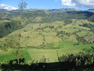
The Cocora Valley is a valley in the Quindío Department of Colombia. It is located in the Central Cordillera of the Andean mountains. "Cocora" was the name of a Quimbayan princess, daughter of the local chief Acaime, and means "star of water".
Cueva de los Guácharos National Natural Park is the oldest national park in Colombia. Located in the western face of the Colombian Eastern Andean Range in the departments of Huila and Caquetá, the park covers an area of 9,000 hectares. The caves formed from the karstic zones of the Magdalena and Caquetá rivers.

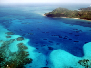
The Tayrona National Natural Park is a protected area in the Colombian northern Caribbean region and within the jurisdiction of the city of Santa Marta, 34 kilometres (21 mi) from the city centre. The park presents a biodiversity endemic to the area of the Sierra Nevada de Santa Marta mountain range, featuring a variety of climates and geography that ranges from arid sea level to 900 meters above sea level. The park covers approximately 30 square kilometres (12 sq mi) of maritime area in the Caribbean Sea and approximately 150 square kilometres (58 sq mi) of land.

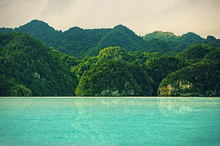
Soberanía National Park is a national park in Panama near the banks of the Panama Canal in the provinces of Panamá and Colón, some 25 kilometres (16 mi) from Panama City. The Chagres River runs through the park. Established as a national park in 1980, the park covers 55,000 acres (220 km2).
Los Haitises National Park is a national park located on the remote northeast coast of the Dominican Republic that was established in 1976. It consists of a limestone karst plateau with conical hills, sinkholes and caverns, and there is a large area of mangrove forest on the coast. Other parts of the park are clad in subtropical humid forest and the area has an annual precipitation of about 2,000 mm (79 in). The park contains a number of different habitats and consequently has a great diversity of mammals and birds, including some rare species endemic to the island. Some of the caverns contain pictograms and petroglyphs. The park has become a popular ecotourism destination but the number of tourists allowed to visit is limited.

The Cumbres de Monterrey is a national park of Mexico located in the northern portion of the Sierra Madre Oriental in the states of Nuevo León and Coahuila, near the city of Monterrey. The park protects more than 1,770 square kilometres (680 sq mi) of rugged terrain boasting deep canyons, rivers, waterfalls, and scenic mountain peaks, including the Cerro de la Silla, part of Monterrey's famous skyline.
The Old Providence McBean Lagoon National Natural Park is a national park located on the northeast side of Providencia Island in the Archipelago of San Andrés, Providencia and Santa Catalina, Colombia.
The Rosario and San Bernardo Corals National Natural Park is a natural park located in the Sucre and Bolívar Departments on the coast of the Caribbean Region of Colombia, 45 km from the Bay of Cartagena. It was the most visited national park in Colombia in 2009, with 318,473 visitors.
El Tuparro National Natural Park is a national park located in the Vichada Department in the Orinoquía Region of Colombia. It is the only protected area in the Eastern Plains under Colombia's Natural Parks System.

The Salamanca Island Road Park is a national park located in the Caribbean Region of Colombia, on the western outskirts of the city of Ciénaga in the Magdalena Department. The flora and fauna is in abundance because of the confluence of sweet water flowing from the Magdalena River and saline water of the Caribbean Sea. It was created in 1964 to protect the abundant bird life and coastal mangroves.
The "El mono Hernández" Cork Forest Flora and Fauna Sanctuary is a natural monument located in the Sucre and Bolívar Departments on the coast of the Caribbean Region of Colombia.
The Tamá National Natural Park is a national park located in the Tamá Massif of the Andean Region of Colombia, between the municipalities Toledo and Herrán, in the department of Norte de Santander, in the northeastern part of the Eastern Ranges of the Colombian Andes. One of the main attractions of the park is a 820-metre-high (2,690 ft) waterfall, one of the world's highest.
The Puracé National Natural Park is a national park located in the Andean region of Colombia, southeast of the city of Popayán in the Cordillera Central range. Its main feature is the active stratovolcano Puracé, one of Colombia's most active volcanoes. Four of the country's most important rivers originate within the area: Magdalena River, Cauca River, Japurá River and Patía River.

The Tamá Massif is a group of mountains on the border between Colombia and Venezuela to the south of Lake Maracaibo. It contains evergreen rainforest and cloud forest at the lower levels, and páramos at the highest levels.

Caño Martín Peña Nature Reserve is a nature reserve in San Juan, Puerto Rico located along the 3.75 mile long Martín Peña Channel. The nature reserve protects wetlands and an urban mangrove forest which extends throughout the channel between the Los Corozos and San José Lagoons in the east and the San Juan Bay in the west, and between the districts of Santurce in the north and Hato Rey in the south. This reserve is managed by the Puerto Rico Department of Natural and Environmental Resources (DRNA) and belongs to the larger San Juan Bay National Estuary, the only tropical estuary in the National Estuary Program network.
Tatamá National Natural Park is a national park in the Cordillera Occidental, Colombia. Established in 1987, the park encompasses 51,900 ha of primary west-Andean tropical and subtropical rainforest, temperate cloud forest, and páramo habitat in an area that spans the departments of Risaralda, Chocó and Valle del Cauca, within the Chocó bioregion.
