
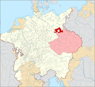
Lusatia is a historical region in Central Europe, split between Germany and Poland. Lusatia stretches from the Bóbr and Kwisa rivers in the east to the Pulsnitz and Black Elster rivers in the west, and is located within the German states of Saxony and Brandenburg as well as in the Polish voivodeships of Lower Silesia and Lubusz. Lusatia's central rivers are the Spree and the Lusatian Neisse, which constitutes the border between Germany and Poland since 1945. The Lusatian Mountains, separate Lusatia from Bohemia in the south. Lusatia is traditionally divided into Upper Lusatia and Lower Lusatia.

Großräschen is a town in Lower Lusatia, in Germany. Administratively, it is part of the district of Oberspreewald-Lausitz, in the state of Brandenburg.
Lower Lusatia is a historical region in Central Europe, stretching from the southeast of the German state of Brandenburg to the southwest of Lubusz Voivodeship in Poland. Like adjacent Upper Lusatia in the south, Lower Lusatia is a settlement area of the West Slavic Sorbs whose endangered Lower Sorbian language is related to Upper Sorbian and Polish.
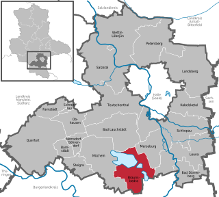
Braunsbedra is a town in the Saalekreis district, in Saxony-Anhalt, Germany. It is situated approximately 11 km southwest of Merseburg.

The Lusatian Lake District is a chain of artificial lakes under construction in Germany across the north-eastern part of Saxony and the southern part of Brandenburg. Through flooding as a part of an extensive regeneration programme, several decommissioned lignite opencast mines are in the process of being transformed into Europe's largest artificial lake district. However, the requirements of the project, especially the necessary water resources, are controversial.

The Berzdorfer See or Lake Berzdorf is located at the southern city limits of Görlitz in Upper Lusatia. It consists of the residual hole of the former Berzdorf open-cast lignite mine, which was flooded from 2002 to the beginning of 2013. The lake forms the southeastern corner of the Lusatian Lake District. With its volume of about 330 million cubic meters and a water depth of max. 72 meters on an area of 960 hectares, it is one of the largest lakes in Saxony. Its name derives from the small village Berzdorf, which was devastated in 1969/70.

Altdöbern is a municipality in the Oberspreewald-Lausitz district, in southern Brandenburg, Germany.

F60 is the series designation of five overburden conveyor bridges used in brown coal (lignite) opencast mining in the Lusatian coalfields in Germany. They were built by the former Volkseigener Betrieb TAKRAF in Lauchhammer and are the largest movable technical industrial machines in the world. As overburden conveyor bridges, they transport the overburden which lies over the coal seam. The cutting height is 60 m (200 ft), hence the name F60. In total, the F60 is up to 80 m (260 ft) high and 240 m (790 ft) wide; with a length of 502 m (1,647 ft), it is described as the lying Eiffel tower, making these behemoths not only the longest vehicle ever made—beating Seawise Giant, the longest ship—but the largest vehicle by physical dimensions ever made by humankind. In operating condition, it weighs 13,600 metric tons making the F60 also one of the heaviest land vehicles ever made, beaten only by Bagger 293, which is a giant bucket-wheel excavator. Nevertheless, despite its immense size, it is operated by only a crew of 14.

Lake Senftenberg is an artificial lake in Landkreis Oberspreewald-Lausitz, Brandenburg, Germany. It is located in the Lusatian Lake District, a chain of artificial lakes. The lake is located on the border of Lower and Upper Lusatia between the southern Brandenburg city of Senftenberg and its districts Niemtsch and Großkoschen. Lake Senftenberg is one of the largest artificial lakes in Germany with an area of 1300 hectares.
The Geisel valley is a valley in Saxony-Anhalt, Germany, situated west of Merseburg, Saalekreis district. It is named after the River Geisel which rises in Mücheln and is a tributary of the Saale, just under 25 km (16 mi) long.
The Tagebau Hambach is a large open-pit coal mine in Niederzier and Elsdorf, North Rhine–Westphalia, Germany. It is operated by RWE and used for mining lignite.

The Visonta Coal Mine ([]) is an open pit lignite mine located near Gyöngyös, Heves County, in Hungary. It is the smallest lignite mine in Hungary out of three lignite mines in total. The mine has coal reserves amounting to 400 million tonnes of lignite, one of the largest coal reserves in Europe and the world and has an annual production of 3.9 million tonnes of coal.

Hosena station is a station at the junction of the Węgliniec–Roßlau railway and the Lübbenau–Kamenz railway. The station is located in the southeast of the German state of Brandenburg in the village of Hosena, north of the village of Hohenbocka.

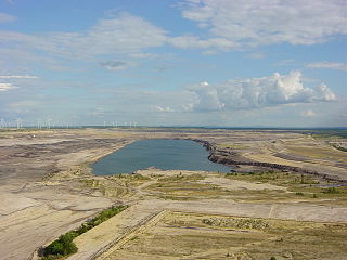
Geiseltalsee, literally Geisel valley lake, is at about 1,840 hectares the largest artificial lake by area in Germany. Once flooding of the Cottbuser Ostsee is complete it will surpass Geiseltalsee in surface area, covering 19 square kilometres (7.3 sq mi). Geiseltalsee lies in the Saalekreis district of the state Saxony-Anhalt. The lake was created in 2003-11 by flooding a former opencast lignite mine in the Geiseltal ; the name of that valley had become widely known due to the notable fossil record which emerged from that coal mine.
A conveyor bridge is a piece of mining equipment used in strip mining for the removal of overburden and for dumping it on the inner spoil bank of the open-cut mine. It is used together with multibucket excavators, frequently bucket chain excavators, that remove the overburden which is moved to the bridge by connecting conveyors. Conveyor bridges are used in working horizontally layered deposits with soft overburden rock in areas where mean annual temperatures are above freezing. They are frequently used in lignite mining.
The Bergheider See, south of Finsterwalde near Lichterfeld in the county of Elbe-Elster in Germany, is a flooded pit from the former open cast mine of Klettwitz-Nord, northeast of the Lower Lusatian Heath. The lake was named after the old village of Bergheide, which had to be abandoned for the brown coal pit.

Bagger 1473 is a bucket-wheel excavator left abandoned in a field in the municipality of Schipkau in Germany.

Lake Puketirini is a former opencast coal mine, immediately to the west of Huntly and east of the larger, but much shallower Lake Waahi, in the Waikato Region. It is circled by a walkway.

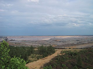
The Rheinisches Braunkohlerevier, often called the Rhenish mining area, is a lignite mining area or district in the Cologne Bay, on the northwestern edge of the Rhenish Slate Mountains. The mining of lignite using the open pit method has had a significant impact on the landscape here and led to the formation of several important industrial sites. The area includes the Zülpicher and Jülicher Börde, the Erft lowlands and the Ville, making it the largest lignite mining area in Europe. To a lesser extent clay, silica sand and loess are mined here. The area is the only active lignite mining area in what was West Germany during German partition and contains the mines with the largest surface area, greatest depth, and biggest annual output of coal.

The Cospudener See is an artificially constructed lake situated directly on the southern outskirts of Leipzig, Germany. Leipzig, Markkleeberg and Zwenkau have shares in the lake which is on the site of a former open cast mine. The lake is popularly known as "Cossi", more rarely "Cospi", and has become highly popular with the local population, with long stretches of sand beaches and with a sauna directly located at the lake. There is also a small sailing harbor. The lake is a part of the Central German Lake District.


