Miami Beach, Barbados

Last updated
Miami Beach, Barbados from Enterprise Coast Road Miami Beach, Barbados.jpg
Miami Beach, Barbados from Enterprise Coast Road

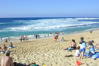
Miami Beach, Barbados, near the town of Oistins, is a popular sandy beach in Barbados. It is located on the south coast of the island, with usually calm waters and brilliant sunset views. On its north side is Enterprise Beach, a much more sheltered bay popular with families. Miami Beach is popular with both locals and tourists. Each morning local seniors swim in the sea and exercise on the beach. Also a great break for bodysurfing and bodyboarding.

Oistins Town in Christ Church, Barbados

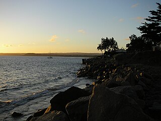
Oistins, is a coastal area located in the country of Barbados. Situated centrally along the coastline of the parish of Christ Church, Through Statutory Instrument (S.I) 1984 No. 141, Road Traffic Act, CAP. 295, ROAD TRAFFIC REGULATIONS, and under Schedule Section # 6: The Boundaries of Bridgetown, Speightstown, Holetown and Oistin are cited as follows: 4) "Oistins: The section of Highway 7 from its junction with Cane Vale Road to its junction with Keizer Hill Road." The area operates mostly as a fishing village and a tourist hang out, containing a collection of bars, rumshops, and shopping centers.

Barbados country in the Caribbean

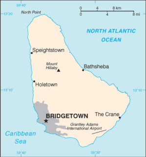
Barbados is an island country in the Lesser Antilles of the West Indies, in the Caribbean region of North America. It is 34 kilometres in length and up to 23 km (14 mi) in width, covering an area of 432 km2 (167 sq mi). It is situated in the western area of the North Atlantic and 100 km (62 mi) east of the Windward Islands and the Caribbean Sea; therein, Barbados is east of the Windwards, part of the Lesser Antilles, roughly at 13°N of the equator. It is about 168 km (104 mi) east of both the countries of Saint Lucia and Saint Vincent and the Grenadines and 400 km (250 mi) north-east of Trinidad and Tobago. Barbados is outside the principal Atlantic hurricane belt. Its capital and largest city is Bridgetown.

A large yellow lifeguard station stands at the junction between Miami Beach and Enterprise Beach.

It is also a popular docking area for cruises on board a catamaran. Miami Beach has a beach shopping complex and a snack bar which serves a range of local food and rum punch. There are also gardens close by. Miami Beach has been voted one of the Top 10 beaches in Barbados. [1]

Catamaran multi-hulled watercraft featuring two parallel hulls of equal size. It is a geometry-stabilized craft, deriving its stability from its wide beam, rather than from a ballasted keel as with a monohull sailboat

A catamaran is a multi-hulled watercraft featuring two parallel hulls of equal size. It is a geometry-stabilized craft, deriving its stability from its wide beam, rather than from a ballasted keel as with a monohull sailboat. Catamaran is from a Tamil word, kattumaram, which means "logs tied together".

In 2004 the beach started to suffer erosion by the sea as a natural occurrence, and the beach is narrower than it was 20 years ago. Action by the local authorities (Barbados Coastal Zone Management Unit (CZMU) and the National Conservation Commission (NCC) has successfully stopped the erosion and started a programme, which is currently allowing the beach to naturally heal itself.

Miami Beach is considered to be a "local hangout place" by those who live near it. [2]

Related Research Articles

Beach Area of loose particles at the edge of the sea or other body of water

A beach is a landform alongside a body of water which consists of loose particles. The particles composing a beach are typically made from rock, such as sand, gravel, shingle, pebbles. The particles can also be biological in origin, such as mollusc shells or coralline algae.

Geography of Barbados

Barbados is a continental island in the North Atlantic Ocean and is located at 13°10' north of the equator, and 59°32' west of the Prime Meridian. As the easternmost isle of the Lesser Antilles in the West Indies, Barbados lies 100 kilometres (62 mi) east of the Windward Islands and Caribbean Sea. The maritime claim for Barbados is a territorial sea of 12 nmi, with an exclusive economic zone of 200 nmi, this gives Barbados a total maritime area of 183,436 km2. Of the total EEZ area 70,000 km2, is set aside for offshore oil exploration. A pending application to UNCLOS has placed for consideration a continental shelf 200 nmi to the east and south. To the west, however, most of Barbados' maritime boundaries consist of median lines with neighbours. These neighbours include: Martinique, and Saint Lucia to the northwest, Saint Vincent and the Grenadines to the west, Trinidad and Tobago and Venezuela to the southwest, and Guyana to the southeast.

Ustka Place in Pomeranian, Poland

Ustka is a town in the Middle Pomerania region of northwestern Poland with 17,100 inhabitants (2001). It is also part of Słupsk County in Pomeranian Voivodeship since 1999, and was previously in Słupsk Voivodeship (1975–1998).

Somers, Victoria Town in Victoria, Australia

Somers is a small town approximately 72 km south-east of Melbourne, Victoria, Australia, in the south-eastern corner of the Mornington Peninsula on Western Port. Its local government area is the Shire of Mornington Peninsula.

Christ Church, Barbados Parish in Barbados

The parish of Christ Church is one of eleven historic political divisions of Barbados. It has a land area of 57 km2 (22 sq mi) and is found at the southern end of the island. Christ Church has survived by name as one of the original six parishes created in 1629 by Governor Sir William Tufton.

Harrisons Cave cave in Barbados

Harrison's Cave is a tourist attraction in the country of Barbados, first mentioned in 1795. Tourists can access the subterranean environment on a tramway.

Christ Church Parish Church church

The current Christ Church Parish Church located in Oistins, Christ Church, Barbados was built in 1935 and is the fifth parish church on the site. At various times the previous structures have all been destroyed by natural disasters including flood, fire or hurricanes.

Ocean Drive (South Beach)

Ocean Drive is a major thoroughfare in the South Beach neighborhood of Miami Beach.

Sunset Beach (Oahu) A beach on the North Shore of Oahu in Hawaii

Sunset Beach is on the North Shore of Oahu in Hawaii and known for big wave surfing during the winter season. The original Hawaiian name for this place is Paumalū. It is a two-mile stretch of mostly beige sand located at 59-104 Kamehameha Highway in Pupukea, 39 miles driving distance from Waikiki. Lifeguards are usually present.

El Médano human settlement

El Médano is a town in the municipality of Granadilla de Abona, on the island of Tenerife, one of the Canary Islands.

Paynes Bay sometimes called the "Platinum Coast" is located on the west coast of Barbados. Many locals believe that it is one of the island's best swimming beaches for both the calm seas of the Caribbean and the colorful neighborhood. In recent years, Paynes Bay has experienced significant development, most recently by various foreign speculators who are in the process of constructing condominiums along the bay.

Foul Bay, Barbados

Foul Bay refers to a bay, beach, and village in Saint Philip Parish, alongside the southeast coast of Barbados.

Southerndown village in United Kingdom

Southerndown is a village in southern Wales to the southwest of Bridgend, in St Brides Major community, close to Llantwit Major and Ogmore-by-Sea. It is mostly known for its beach, which is a popular tourist destination during the summer months and since 1972 has been designated a Heritage Coast and is part of the Southerndown Coast SSSI. When the tide is out there is an expanse of sand and pools. The cliffs are an obvious example of sedimentary rock.

Rickenbacker Causeway Bridge in Florida, United States of America

The Rickenbacker Causeway is a causeway which connects Miami, Florida, United States to the barrier islands of Virginia Key and Key Biscayne across Biscayne Bay.

Flagler Monument Island Neighborhood of Miami Beach in Miami-Dade County, Florida, United States

Flagler Memorial Island is an uninhabited artificial island of South Beach in the city of Miami Beach in Biscayne Bay, Florida, United States. A 110-foot (34 m) high obelisk with allegorical sculptures at its base stands as a monument to Miami pioneer Henry M. Flagler, and was built in the center of the freshly constructed island in memory of Flagler, who died in 1913.

Bellairs Research Institute

The Bellairs Research Institute, located on the Caribbean island of Barbados, was founded in 1954 as a field-station for McGill University. Initial funding was from a bequest by British naval commander, Carlyon Bellairs, for whom the institute is named. Bellairs is located in Holetown, next to Folkestone Marine Park and Museum, on the western beach of the island.

Graeme Hall Nature Sanctuary

Graeme Hall Nature Sanctuary occupies 42 per cent of the Ramsar wetland at Graeme Hall, in Christ Church, Barbados. It is owned by Peter Allard, a Canadian investor and philanthropist. In late 2011 he was named Queen's Counsel by the province of British Columbia. He has put more than US$35 million into the 35-acre eco-tourism site to preserve the last and significant mangrove woodland and wetland on Barbados.

A coastal development hazard is something that affects the natural environment by man-made products.

Lundy is an unincorporated community in Texas County, in the U.S. state of Missouri.

Barbados Railway Narrow-gauge railway

The Barbados Railway was a 38.6-kilometre (24.0 mi)-long narrow-gauge railway on Barbados with a gauge of initially 1,067 mm and later 762 mm. It had 98 bridges, very tight radii and a steep incline. It was used from 1883 to 1937, after it had gone several times through financial difficulties.

References

  1. "Beaches in Barbados".
  2. "A bike tour of the real Barbados". November 25, 2018.

Coordinates: 13°3′35″N59°32′23″W / 13.05972°N 59.53972°W / 13.05972; -59.53972

Geographic coordinate system Coordinate system

A geographic coordinate system is a coordinate system that enables every location on Earth to be specified by a set of numbers, letters or symbols. The coordinates are often chosen such that one of the numbers represents a vertical position and two or three of the numbers represent a horizontal position; alternatively, a geographic position may be expressed in a combined three-dimensional Cartesian vector. A common choice of coordinates is latitude, longitude and elevation. To specify a location on a plane requires a map projection.