
Herāt is the third-largest city of Afghanistan. It has a population of about 436,300, and serves as the capital of Herat Province, situated in the fertile valley of the Hari River in the western part of the country. It is linked with Kandahar, Kabul, and Mazar-i-Sharif via Highway 1 or the ring road. It is further linked to the city of Mashhad in neighboring Iran through the border town of Islam Qala, and to Mary in Turkmenistan to the north through the border town of Torghundi.
The history of Turkmenistan is largely shrouded in mystery, its past since the arrival of Indo-European Iranian tribes around 2000 BC is often the starting point of the area's discernible history. Early tribes were nomadic or semi-nomadic due to the arid conditions of the region as the steppe culture in Central Asia was an extension of a larger Eurasian series of horse cultures which spanned the entire spectrum of language families including the Indo-Europeans and Turko-Mongol groups. Some of the known early Iranian tribes included the Massagatae, Scythians/Sakas, and early Soghdians. Turkmenistan was a passing point for numerous migrations and invasions by tribes which gravitated towards the settled regions of the south including ancient Mesopotamia, Elam, and the Indus Valley Civilization.

Turkmenistan, formerly known as Turkmenia, officially the Republic of Turkmenistan, is a country in Central Asia, bordered by Kazakhstan to the northwest, Uzbekistan to the north and east, Afghanistan to the southeast, Iran to the south and southwest, and the Caspian Sea to the west. Ashgabat is the capital and largest city. The population of the country is 5.6 million, the lowest of the Central Asian republics and one of the most sparsely populated in Asia.
Merv was a major oasis-city in Central Asia, on the historical Silk Road, located near today's Mary in Turkmenistan. Several cities have existed on this site, which is significant for the interchange of culture and politics at a site of major strategic value.

Khorasan, sometimes called Greater Khorasan, is a historical region lying in northeast of Greater Persia, including part of Central Asia and Afghanistan. The name simply means "East, Orient" and loosely includes the territory of the Sasanian Empire north-east of Persia proper. Early Islamic usage often regarded everywhere east of so-called Jibal or what was subsequently termed 'Iraq Ajami', as being included in a vast and loosely-defined region of Khorasan, which might even extend to the Indus Valley and Sindh. During the Islamic period, Khorasan along with Persian Iraq were two important territories. The boundary between these two was the region surrounding the cities of Gurgan and Qumis. In particular, the Ghaznavids, Seljuqs and Timurids divided their empires into Iraqi and Khorasani regions.

Termez is a city in the southernmost part of Uzbekistan near the Hairatan border crossing of Afghanistan. It is the hottest point of Uzbekistan. It has a population of 140,404, and is the capital of Surxondaryo Region.

The Kopet Dag, Kopet Dagh, or Koppeh Dagh, also known as the Turkmen-Khorasan Mountain Range, is a mountain range on the border between Turkmenistan and Iran that extends about 650 kilometres (400 mi) along the border southeast of the Caspian Sea, stretching northwest-southeast from near the Caspian Sea in the northwest to the Harirud River in the southeast. The highest peak of the range in Turkmenistan is the Mount Rizeh, located at the southwest of the capital Ashgabat and stands at 2,940 metres (9,646 ft). The highest Iranian summit is Mount Quchan with 3,191 metres (10,469 ft).

Aberuthven is a small village in Perth and Kinross, Scotland. It lies approximately 2 1⁄2 miles (4.0 km) north-east of Auchterarder and 10 miles (16 km) south-west of Perth at an elevation of 128 feet (39 m). It lies on the A9 and A824 roads which has been bypassed along with Auchterarder since 1983. The village is centred on the village hall and has changed over the years almost doubling in size and population.

Sarakhs is a city and capital of Sarakhs County, Razavi Khorasan Province, Iran. Sarakhs was once a stopping point along the Silk Road, and in its 11th century heyday had many libraries and a famous school of architects. Much of the original city site is now just across the border at Serakhs in Turkmenistan. According to the most recent national census, in 2006, the city's population was 33,571 in 8,066 families.

Abu Kamal or Al-Bukamal is a city on the Euphrates river in the Deir ez-Zor Governorate of eastern Syria near the border with Iraq. It is the administrative centre of the Abu Kamal District and the local subdistrict. Just to the south-east is the Al-Qa'im border crossing to the town of Husaybah in the Al-Qa'im District of Iraq's Al Anbar Governorate.
Torbat-e Jam is a city and capital of Torbat-e Jam County, in Khorasan Province, Iran. At the 2016 census, its population was 100,449. Torbat-e Jam is one of the ancient cities of Greater Khorasan.

Astaneh-ye Ashrafiyeh is a city and capital of Astaneh-ye Ashrafiyeh County, Gilan Province, Iran. At the 2006 census, its population was 36,298, in 10,558 families.

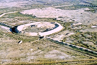
Serakhs is an oasis city in Ahal Province of Turkmenistan. It is located at latitude 36°31' North; longitude 61°12' East and an altitude of 285m above sea level. It is one of the oases of the ancient Silk Road lying between Merv to the east and Mashhad to the west. In 1989 the city had a population of 9,585.

Bashanabad is a village in Baharak District, Badakhshan Province in north-eastern Afghanistan.

Akyazı is a village in the District of Amasya, Amasya Province, Turkey. In 2012 it had a population of 41.

′Ataman, also spelled ′Atman, Athman, Osmane or Othman, is a village in southern Syria, administratively part of the Daraa Governorate, located 4 kilometers north of Daraa. Other nearby localities include al-Yadudah to the west, Tafas to the northwest, Da'el to the north, Khirbet Ghazaleh to the northeast, al-Ghariyah al-Gharbiyah to the east and al-Naimah to the southeast. According to the Syria Central Bureau of Statistics, Ataman had a population of 8,929 in the 2004 census.
Miyana is a Pashtun (Pathan) tribe having their origin from Mianishien Mountains in Kandahar, Afghanistan.

The Iran-Turkmenistan border is 1,148km in length and runs from the Caspian Sea to the tripoint with Afghanistan. The Turkmen capital Ashgabat is only 15 miles north of this boundary, and Mashhad is 47 miles south of it.


