
Big Arm is a census-designated place (CDP) in Lake County, Montana, United States. The population was 131 at the 2000 census.
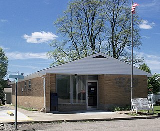
Bloomingdale is a village in Jefferson County, Ohio, United States. The population was 202 at the 2010 census. It is part of the Weirton–Steubenville, WV-OH Metropolitan Statistical Area.

Dildo is a community on the island of Newfoundland, in the province of Newfoundland and Labrador, Canada. It is located on the southeastern Dildo Arm of Trinity Bay about 60 kilometres (37 mi) west of St. John's. South Dildo is a neighbouring community of 250 residents. The town's unusual name has brought it a certain amount of notoriety.
Sunnyside is a town on the Avalon Peninsula in Newfoundland and Labrador, Canada. It is in Division 1 on Bull Arm.

The Feather River is the principal tributary of the Sacramento River, in the Sacramento Valley of Northern California. The river's main stem is about 73 miles (117 km) long. Its length to its most distant headwater tributary is just over 210 miles (340 km). The main stem Feather River begins in Lake Oroville, where its four long tributary forks join together—the South Fork, Middle Fork, North Fork, and West Branch Feather Rivers. These and other tributaries drain part of the northern Sierra Nevada, and the extreme southern Cascades, as well as a small portion of the Sacramento Valley. The total drainage basin is about 6,200 square miles (16,000 km2), with approximately 3,604 square miles (9,330 km2) above Lake Oroville.

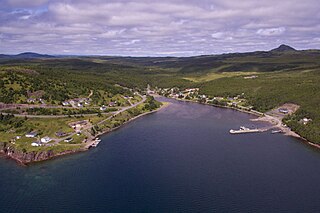
Chapel Arm is a settlement in Newfoundland, Canada, located at the southeast corner of Trinity Bay, approximately 100 km (62 mi) west of St. John's and two km from the Trans-Canada Highway.
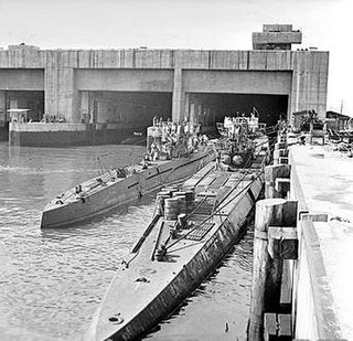
A submarine pen is a type of submarine base that acts as a bunker to protect submarines from air attack. The term is generally applied to submarine bases constructed during World War II, particularly in Germany and its occupied countries, which were also known as U-boat pens.
Shuswap Lake Marine Provincial Park is an 896-hectare provincial park in British Columbia, Canada, comprising 991 ha. The Park has a variety of amenities including boat launch ramps, picnic areas, and 27 campsites around the perimeter of Shuswap Lake. The lake's name and that of the surrounding Shuswap Country is from the Shuswap people (Secwepemc), the most northern of the Salishan speaking people.
Squires Gate is a district and an electoral ward in South Shore, Blackpool on the Fylde coast in the county of Lancashire, England. It is located at the south of the town near the boundary with Lytham St Annes. The population of the ward taken at the 2011 census was 6,437.

The North Branch of the Millers River is a river in southwestern New Hampshire and northern Massachusetts in the United States. It is a tributary of the Millers River, which flows west to the Connecticut River, which in turn flows south to Long Island Sound, an arm of the Atlantic Ocean.
Colinet is an incorporated town located on the northwest arm of St. Mary's Bay in Newfoundland and Labrador, Canada.

Haj Shahbazkhan Mosque is a mosque located in the Ojagh Crossroads of Kermanshah, Iran.

Zinc finger protein 202 is a transcription factor first associated with breast cancer. It is a protein that, in humans, is encoded by the ZNF202 gene.
Bull Arm is a natural arm of approximately 10 miles in length and average of 1 mile wide located at the Isthmus of Avalon on the Avalon Peninsula in the Canadian province of Newfoundland and Labrador. The inner reaches of the arm is located at Sunnyside, and from there it is a mere 2.72 miles to Placentia Bay at Come by Chance.
The Becklin–Neugebauer Object(BN) is an object visible only in the infrared in the Orion Molecular Cloud. It was discovered in 1967 by Eric Becklin and Gerry Neugebauer during their near-infrared survey of the Orion Nebula.

Empire Bowman was a 7,030 GRT cargo ship built in 1942 for the Ministry of War Transport (MoWT). Completed in May 1942, she served until 30 March 1943 when she was torpedoed and sunk by U-404. One of her crew was awarded an Albert Medal for his actions in the sinking.

The Isuzu 6H is a family of inline-6 cylinder Diesel engine installed in Isuzu medium duty trucks, and also installed in GM medium-duty trucks as the Duramax LG4. It is mated to the Allison 2500, 3000 and 3500 Series transmissions.

Grove House, in Oxford Road, Chorlton-on-Medlock, Manchester, is an early Victorian building, originally three houses, of 1838–40. It is a Grade II* listed building as of 18 December 1963.

Tyersal Beck is a watercourse in West Yorkshire, England, named after the village of Tyersal in whose vicinity it runs.

The Burnley Coalfield is the most northerly portion of the Lancashire Coalfield. Surrounding Burnley, Nelson, Blackburn and Accrington, it is separated from the larger southern part by an area of Millstone Grit that forms the Rossendale anticline. Occupying a syncline, it stretches from Blackburn past Colne to the Yorkshire border where its eastern flank is the Pennine anticline.
