
East Lothian is one of the 32 council areas of Scotland, as well as a historic county, registration county and lieutenancy area. The county was called Haddingtonshire until 1921.

Loanhead is a town in Midlothian, Scotland, in a commuter belt to the south of Edinburgh, and close to Roslin, Bonnyrigg and Dalkeith. The town was built on coal and oil shale mining, and the paper industries.
The geology of the county of Shropshire, England is very diverse with a large number of periods being represented at outcrop. The bedrock consists principally of sedimentary rocks of Palaeozoic and Mesozoic age, surrounding restricted areas of Precambrian metasedimentary and metavolcanic rocks. The county hosts in its Quaternary deposits and landforms, a significant record of recent glaciation. The exploitation of the Coal Measures and other Carboniferous age strata in the Ironbridge area made it one of the birthplaces of the Industrial Revolution. There is also a large amount of mineral wealth in the county, including lead and baryte. Quarrying is still active, with limestone for cement manufacture and concrete aggregate, sandstone, greywacke and dolerite for road aggregate, and sand and gravel for aggregate and drainage filters. Groundwater is an equally important economic resource.

The South Wales Coalfield extends across Pembrokeshire, Carmarthenshire, Swansea, Neath Port Talbot, Bridgend, Rhondda Cynon Taf, Merthyr Tydfil, Caerphilly, Blaenau Gwent and Torfaen. It is rich in coal deposits, especially in the South Wales Valleys.
The Somerset Coalfield in northern Somerset, England is an area where coal was mined from the 15th century until 1973. It is part of a larger coalfield which stretched into southern Gloucestershire. The Somerset coalfield stretched from Cromhall in the north to the Mendip Hills in the south, and from Bath in the east to Nailsea in the west, a total area of about 240 square miles (622 km2). Most of the pits on the coalfield were concentrated in the Cam Brook, Wellow Brook and Nettlebridge Valleys and around Radstock and Farrington Gurney. The pits were grouped geographically, with clusters of pits close together working the same coal seams often under the same ownership. Many pits shared the trackways and tramways which connected them to the Somerset Coal Canal or railways for distribution.
The South Yorkshire Coalfield is so named from its position within Yorkshire. It covers most of South Yorkshire, West Yorkshire and a small part of North Yorkshire. The exposed coalfield outcrops in the Pennine foothills and dips under Permian rocks in the east. Its most famous coal seam is the Barnsley Bed. Coal has been mined from shallow seams and outcrops since medieval times and possibly earlier.
Prestongrange Museum is an industrial heritage museum at Prestongrange between Musselburgh and Prestonpans on the B1348 on the East Lothian coast, Scotland. Founded as the original site of the National Mining Museum, its operation reverted to East Lothian Council Museum Service in 1992.

The Cheadle Coalfield is a coalfield in the United Kingdom. Centred on the town of Cheadle, Staffordshire, and its outlying villages it lies to the east of Stoke-on-Trent and the much larger North Staffordshire Coalfield. The area has been mined for many years, with documentary evidence from Croxden Abbey citing coal mining in the 13th century.
The Walloon Coal Measures are a Late Jurassic geologic subgroup in Queensland, Australia. Deposited within the Surat Basin, it is considered Oxfordian to early Tithonian in age based on lead-uranium dating of tuffites within the unit.

Dr Henry Moubray Cadell of Grange, DL FRSE LLD was a Scottish geologist and geographer, noted for his work on the Moine Thrust, the oil-shale fields of West Lothian, and his experiments in mountain building published in 1888. He also travelled extensively abroad, for example in 1899 he travelled the length of the Irrawaddy River in Burma. He is especially remembered for his working models, explaining geomorphology, the science relating to the folding of rock beds. He was also a competent amateur artist.
The Ingleton Coalfield is in North Yorkshire, close to its border with Lancashire in north-west England. Isolated from other coal-producing areas, it is one of the smallest coalfields in Great Britain.
The Machrihanish Coalfield is a coalfield on the Kintyre peninsula in southwest Scotland. It is one of the smallest British coalfields. With the exception of a thin coal beneath the Lyoncross Limestone in the overlying Upper Limestone Formation, all of the coal-bearing strata are found within the Limestone Coal Formation, a subdivision of the Clackmannan Group; all being strata of Namurian age. There are numerous seams of which the Main Coal is the principal one, being some 3 to 4m thick. A further, higher seam known as the Kilkivan Coal has also been worked. The full sequence is:

The Canonbie Coalfield is a small and largely concealed coalfield at Canonbie in the south of Scotland. A comprehensive survey by Peach and Horne was published in 1903. Canonbie colliery was worked until 1920, and another mine at Archerbeck continued until 1942.

The Manchester Coalfield is part of the South Lancashire Coalfield, the coal seams of which were laid down in the Carboniferous Period. Some easily accessible seams were worked on a small scale from the Middle Ages, and extensively from the beginning of the Industrial Revolution in the early 19th century until the last quarter of the 20th century. The Coal Measures lie above a bed of Millstone Grit and are interspersed with sandstones, mudstones, shales, and fireclays. The Lower Coal Measures occupy the high ground of the West Pennine Moors above Bolton and are not worked in the Manchester Coalfield. The most productive of the coal measures are the lower two thirds of the Middle Coal Measures where coal is mined from seams between the Worsley Four Foot and Arley mines. The deepest and most productive collieries were to the south of the coalfield. The coalfield is affected by the northwest to southeast aligned Pendleton Fault along the Irwell Valley and the Rossendale Valley anticline. The Coal Measures generally dip towards the south and west. Numerous other smaller faults affect the coalfield. The Upper Coal Measures are not worked in the Manchester Coalfield.
The Denbighshire Coalfield in the historic county of Denbighshire in north-east Wales is one of the smaller British coalfields. It extends from near Caergwrle in the north, southwards through Wrexham, Ruabon and Rhosllannerchrugog to Chirk in the south. A small part extends into Shropshire around Oswestry. Beyond Caergwrle the coal-bearing strata continue northwards as the Flintshire Coalfield. Together the two coalfields are known as the North Wales Coalfield.
The Fife Coalfield was one of the principal coalfields in Scotland. Over fifty collieries were in operation at various times between the middle of the nineteenth century and the closure of the last pit in 1988. The coalfield extended across the southern part of Fife where rocks of the Coal Measures Group occur and was one of a series of coalfields throughout the Midland Valley from which coal was won by both deep workings and opencasting methods. It is traditionally divided into the West Fife, Central Fife and East Fife coalfields with Kirkcaldy having been a particularly important area. Some of the mines extended beyond Fife under the Firth of Forth following the seams which occupy the Leven Syncline which extends to the south shore of the firth at Musselburgh and beyond.
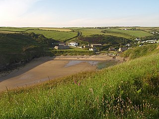
Nolton Haven is a hamlet halfway along the coast of St Bride's Bay in Pembrokeshire, Wales. It is included within the Pembrokeshire Coast National Park. Together with the larger inland village of Nolton which is about 1 km to the southeast and the village of Roch, Nolton Haven falls within Nolton and Roch community.
The geology of Staffordshire in the West Midlands region of England is largely characterised by sedimentary bedrock of late Palaeozoic to early Mesozoic age overlain by a suite of superficial materials deposited during the Quaternary period. The extraction of coal, limestone and clay have been significant industries within the county.

West Lothian, also known as Linlithgowshire, is a historic county in the east central Lowlands of Scotland. until 1925. It is bounded geographically by the Avon to the west and the Almond to the east. It was reshaped significantly following local government reforms in 1975, becoming slightly larger but with major territorial changes: some areas in the north-west were transferred to Falkirk; areas in the north-east were transferred to Edinburgh; and some areas in the south that had formerly been part of Midlothian were added to a new West Lothian District within the Region of Lothian. This then became a standalone local authority area in the most recent major reorganisation enacted in 1996, retaining those same boundaries and name.
